
Schön (municipality of Schwarzenbach)
| Nice ( rotte ) | |||
|---|---|---|---|
|
|||
| Basic data | |||
| Pole. District , state | Wiener Neustadt-Land (WB), Lower Austria | ||
| Pole. local community | Schwarzenbach ( KG Schwarzenbach) | ||
| Locality | Schwarzenbach (absent-minded) | ||
| Coordinates | 47 ° 37 '19 " N , 16 ° 20' 25" E | ||
| height | 510 m above sea level A. | ||
| Post Code | 2803 | ||
| prefix | + 43/02645 | ||
| Statistical identification | |||
| Counting district / district | Schwarzenbach (32326 000) | ||
 Municipal coat of arms |
|||
| Website: www.schwarzenbach.gv.at Source: STAT : Ortverzeichnis ; BEV : GEONAM ; NÖGIS |
|||

The Schön is a group of the market community Schwarzenbach in the district Wiener Neustadt-Land in Lower Austria .
geography
Schön is located on the eastern edge of the Bucklige Welt in the Lower Austrian industrial district on the border with Burgenland at around 510 m above sea level. A. The place is already in the source basin of the Rainbach , which flows into the Schwarzenbach near Kobersdorf in Burgenland , the highest elevation of the Landsee mountains near the place is at 590 m above sea level. A.
On the way from the market to the beautiful lying wasteland Alm (m 500, ⊙ ). The highest elevation of the Alm is 545 m above sea level. A.
Neighboring places:
| Oberau | Schwarzenbach market | |
.svg)
|
||
|
Kindlmühle-Neuris (Gem. Wiesmath ) |
Oberpetersdorf (Gem. Kobersdorf , Bgld.) |
history
Place name
The place name Schön probably indicates names of waters that are no longer used in today's language. They can still be found in several place and field names, however, here the word beautiful mainly has meanings such as 'swamp, marshy, moor'. The word “water” can be derived from a Germanic s cun or s con . This interpretation could be related to the sources of the Rainbach and the Mühlbach. The place name is also interpreted as 'sanctuary' or 'clearing'. In the Josephinische Landesaufnahme the place is also called Auf der Schön , later also Schönhäuser can be found .
The place name Alm is probably the field name Alm (mountain pasture) . In the Theresian cadastre , the place is also called Möszner Alm , to an owner or homestead ( Mößner 'Der am / im Moos', also a wetland name).
Historical maps
- Schwarzenbach and his Rotten (recording sheets of the Josephinische Landesaufnahme and the Franzisco-Josephinische Landesaufnahme )

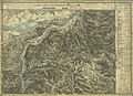
around 1780: on the Schön , Josephinische Landesaufnahme (on the royal Hungarian border)

1880: Schönhäuser (top left, recording sheet of the Franzisco-Josephinische Landesaufnahme )
1880: On the Alm (far right below)


Web links
Individual evidence
- 32326 - Schwarzenbach. Community data, Statistics Austria .
- ↑ Some examples are Schönwald (swamp forest), Schönbach (swampy brook), Schönborn (swamp spring), Schönfeld (wet field), Schönach (swampy brook).
Cadastral communities: Schwarzenbach
Locations: Schwarzenbach | Schwarzenbach (absent-minded)
Market place: Schwarzenbach Rotten: Eggenbuch | Essengraben | Hocheckgraben | Hochegg | Oberau | Beautiful | Schulau | Meets scattered houses: glass moat | Hackbichl | Königsbichl | Bike school pages | Schölderl | Schwarzenbach (absent-minded)
Counting district: Schwarzenbach