
Lichtenwörth
|
market community Lichtenwörth
|
||
|---|---|---|
| coat of arms | Austria map | |
 |
|
|
| Basic data | ||
| Country: | Austria | |
| State : | Lower Austria | |
| Political District : | Wiener Neustadt-Land | |
| License plate : | WB | |
| Surface: | 22.97 km² | |
| Coordinates : | 47 ° 50 ' N , 16 ° 18' E | |
| Height : | 254 m above sea level A. | |
| Residents : | 2,742 (January 1, 2020) | |
| Population density : | 119 inhabitants per km² | |
| Postcodes : | 2493, 2700, 7202 | |
| Area code : | 02622 | |
| Community code : | 3 23 18 | |
| NUTS region | AT122 | |
| Address of the municipal administration: |
Hauptstrasse 1 2493 Lichtenwörth |
|
| Website: | ||
| politics | ||
| Mayor : | Manuel Zusag ( ÖVP ) | |
|
Municipal Council : ( 2020 ) (21 members) |
||
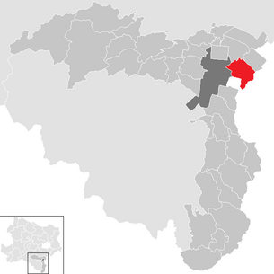
| Location of Lichtenwörth in the Wiener Neustadt-Land district | ||
  |
||
 Lichtenwörth from the south |
||
| Source: Municipal data from Statistics Austria | ||

Lichtenwörth is a market town with 2742 inhabitants (as of January 1, 2020) in the industrial district of Lower Austria .
geography
The community is located east of Wiener Neustadt between the Leitha and the Warmen Fischa .
Community structure
|
structure
|
The only village is Lichtenwörth. The village also includes the districts of Alte Siedlung , Am Stampf , Döttelbach , the Meierhof Fondsgut , the village of Nadelburg , the Neue Siedlung , the village of Waldheim and a single location.
Neighboring communities
The neighboring communities are Wiener Neustadt in the west, Eggendorf in the north, Zillingdorf in the north-west (Lower Austria), and Pöttsching in the south-east, Neudörfl (Burgenland) in the south .
history
Before the birth of Christ, the area was part of the Celtic Kingdom of Noricum and belonged to the surroundings of the Celtic hill settlement Burg on the Schwarzenbacher Burgberg , which was the main town for the entire north-east Noricum .
Later under the Romans, today's Lichtenwörth was then in the province of Pannonia .
Lichtenwörth was first mentioned in a document in the second half of the 12th century. The Salzburg Archbishop Adalbert III. the Vorau monastery in 1174 all parish rights and part of the tithe , which are paid within the boundaries of the "Lutunwerde" area.
In the 12th century, a moated castle was built in a bend in the river of the "warm Fischa" and provided with a moat, which served as protection for the population in the event of attacks by hostile armies. The castle, called "Feste Lichtenwörth", was destroyed by armed conflict between 1487 and 1490. An episcopal courtyard garden was later laid out on the "island" where this castle was located. Today the island with the so-called villa pond is open to the public and is used both as an event location and as a local recreation area.
In 1992 the Lower Austrian Landtag gave Lichtenwörth market rights .
The name Lichtenwörth (formerly Lutunwerde) means a settlement on an island or on an elevation in the middle of a swamp , whereby the forest has been cleared or even removed.
Documentary mention: 1240/57 Lichtenwerde
- The village of Nadelburg
.jpg)
In 1747, under the reign of Maria Theresia, the metal goods and brass needle factory (including wire drawing ) Nadelburg was founded by a sovereign privilege issued in favor of Johann Christian Zug, owner of a copper hammer in Liechtenwörth . As early as 1751, due to its disadvantageous financial situation, the company became the property of the state ( Imperial and Royal Mint and Mining Directorate ). In 1767 the work, which had remained passive, went to Count Theodor Batthyány , after his death by auction to the Viennese wholesaler Anton Hainisch , under whose management the business flourished .
In the pre-March period , the wire drawing mills were replaced by rolling mills and supplemented by a cotton spinning mill . Over 800 different objects such as irons, needles, weights and mortars were created. In the heyday of the factory, a castle-like building was built in 1880, the manorial villa Nadelburg, demolished in 1954. The Nadelburger Metallwarenwerke were closed in 1930.
Due to a lack of public and private understanding, the facility was gradually allowed to deteriorate. It wasn't until 1986, when the ensemble was placed under monument protection, that a rethink began. Among other things, it is thanks to the private initiative of the historically interested Lichtenwörther and house owner in Nadelburg, Franz Gehrer (1924–1997), that both the existence and the history of the Nadelburg should not be further forgotten. In the mid-1980s he founded a local history museum , in which he housed the settlement and factory-related objects that he had collected and then displayed them. Over the years, hundreds of exhibits, photos and documents had accumulated, which are now stored in the Winkelhaus , a privately run museum, which was completed in 1756 .
The remains of the inn, the former social center of the workers' settlement, were demolished in 1991 despite being listed as a historical monument. The sewing needle factory, a building characteristic of the later phase of the complex (sawtooth-shaped shed roof ), fared no better : instead of renovating, it was razed , only two walls remained.
The Nadelburg falls into the origins of industrialization in Austria and is correspondingly significant for industrial, cultural and social history. According to the value analysis published by Manfred Wehdorn in 1984, the workers' settlement, which was built according to a uniform basic plan in the Theresian era, is undoubtedly one of the oldest, still largely uniformly preserved facilities of this type in Europe.
Population development
According to the 2001 census, 2,866 people currently live in Lichtenwörth. This is a continuous increase after 2,507 in 1971, 2,525 in 1981 and 2,723 in 1991.
Listed according to age groups, 18.3% are currently under 15 years old, 61.8% between 15 and 60 years and 19.8% over 60 years old.
Religious development
According to the data of the 2001 census , 70.2% of the population are Roman Catholic and 3.1% Protestant . 10.5% are Muslims , 1.5% belong to Orthodox churches . 13.7% of the population have no religious denomination.
Culture and sights

- Catholic parish church Lichtenwörth hl. James the Elder: Construction of the Gothic style church began as early as the 14th century . Enemy raids and lack of money prevented completion. The building in its present form was not completed until 1889.
- Nadelburg: a workers' settlement , built at the time of Empress Maria Theresa, the original buildings of which have largely been preserved
- One of - Theresa Church in Nadelburg Nicolò Pacassi in baroque built in 1759 style St.. Theresa church.
- Adlertor: The Adlertor is one of the three entrances to the workers' settlement; as a landmark of Lichtenwörth it is kept in good condition.
- Nadelburg Museum: The Nadelburg has a private museum with a historically valuable collection. The museum specifically shows the history of the rule and industries of the Nadelburg.

Nadelburg, Fabriksgasse with Theresienkirche

Nadelburg, east entrance to Adlertor , behind Adlertorgasse

Nadelburg, Fabriksgasse , remains of the aforementioned former inn and stable (around 1982)
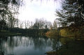
Nadelburg, Villateich , view from the island entrance over the embankment to the Theresienkirche (around 1982)

Interior view of the Nadelburg Museum, large showroom


.jpg)
.jpg)

Economy and Infrastructure
In 2001 there were 80 non-agricultural workplaces, agricultural and forestry operations 69 according to the 1999 survey. According to the 2001 census, the number of people in employment at home was 1284. In 2001, the activity rate was 48.22 percent.
- Contaminated sites: An abandoned sand and gravel pit was operated as a "SAD landfill" and between 1973 and 1989 it was filled with approx. 650,000 m³ of waste on an area of around 50,000 m². This old deposit has a high potential to form landfill gas, however, a widespread spread of landfill gas has not yet been determined. In places the deposits are heavily contaminated with chlorinated hydrocarbons and the quality of the groundwater is significantly changed by seepage from the landfill. The old deposit therefore poses a considerable risk to the environment.
traffic
- Street: The eastern bypass of Wiener Neustadt is planned at the western municipal boundary .
education
- In Lichtenwörth there are two kindergartens , an elementary school , a secondary school and a music school.
politics
The municipal council has 21 members.
- With the municipal council elections in Lower Austria in 1990, the municipal council had the following distribution: 11 SPÖ, 7?, And 3 ÖVP.
- With the municipal council elections in Lower Austria in 1995, the municipal council had the following distribution: 12 SPÖ, 3 ÖVP, 3 non-partisan community Lichtenwörth, and 3 ÖAAB.
- With the municipal council elections in Lower Austria in 2000, the municipal council had the following distribution: 13 SPÖ, 5 ÖVP, 1 non-partisan community Lichtenwörth, 1 independent forum, and 1 FPÖ.
- With the municipal council elections in Lower Austria in 2005 , the municipal council had the following distribution: 14 SPÖ, 5 ÖVP, and 2 Independent Forum.
- With the municipal council elections in Lower Austria 2010 , the municipal council had the following distribution: 11 SPÖ, 5 ÖVP, 4 list Pro Lichtenwörth, and 1 independent forum.
- With the municipal council elections in Lower Austria in 2015 , the municipal council had the following distribution: 12 SPÖ, 5 ÖVP, 2 list Pro Lichtenwörth, 1 list Wolfgang Paar, and 1 FPÖ.
- With the municipal council elections in Lower Austria 2020 , the municipal council has the following distribution: 10 SPÖ, 9 ÖVP (We all are Lichtenwörth), 1 Zukunft Lichtenwörth (ZL) and 1 FPÖ.
mayor
- 1945 August Novak
- 1945 Franz Herzog
- 1945–1948 Josef Lehner
- 1948–1950 Josef Bauer
- 1950–1975 Karl Neidel
- 1975–1987 Richard Bayer
- 1987-2007 Alois Proksch (SPÖ)
- 2007-2014 Manfred Augusztin (SPÖ)
- 2014–2020 Harald Richter (SPÖ)
- since 2020 Manuel Zusag (ÖVP)
coat of arms
Blazon : in a black shield a golden orb with a red band, which is surrounded by two green palm branches that cross in the base of the shield and above which a five-pointed crown hovers.
For the design of the coat of arms, which was awarded in 1978, the emblems crown and orb , which have been used in the local seal since the end of the 18th century, were used and combined with two palm branches to form a unit.
Personalities
- Dominic Thiem (* 1993), professional tennis player
literature
- Herbert Matis: The manufactory and early factory in the quarter under the Vienna Woods. An investigation into the beginnings of large-scale companies from the age of mercantilism to 1848 . Part 3: The manufactories and factories according to the individual branches of production . Vienna, Univ., Diss., 1965.
- Manfred Wehdorn [tutor]: “Nadelburg” workers' settlement, Lichtenwörth, Lower Austria. Preservation exercises at the Institute for Art History and Preservation of Monuments at the Technical University of Vienna in the academic year 1979/1980 . Institute for Art History and Monument Preservation, Vienna University of Technology, Vienna 1979.
- Manfred Wehdorn, Ute Georgeacopol-Winischhofer: Architectural monuments of technology and industry in Austria. Volume 1, Vienna, Lower Austria, Burgenland. Böhlau, Vienna / Graz (among others) 1984, ISBN 3-205-07202-2 .
- Adalbert Haider: The Nadelburg - a contribution to contemporary and economic history . Timeline; Weilburg-Verlag, Wiener Neustadt 1988, ISBN 3-900100-72-1 .
- Robert Bachtrögl: The Nadelburg - History from 1747 . The most extensive and informative work about the Nadelburg, Heimatverlag, 2010, 225 pages, with a splendid cover, limited edition of 1000 pieces.
- Ilse Huber: ORF Ö1, radio broadcast, radio protocol - from manufacture to mass production. How the economy shapes the Lower Austrian industrial district. Series in 4 parts. 10-13 October 2016. oe1.orf.at - 7 days audible.
Web links
- 32318 - Lichtenwörth. Community data, Statistics Austria .
Individual evidence
- ^ Matis: Manufaktur , 3rd T., p. 367 f.
- ↑ The construction of the workers' settlement was completed by 1756 at the latest . - In: Wehdorn, Baudenkmäler , p. 188.
- ↑ In the vicinity of this area, the Verein Industriedenkmal Nadelburg was founded in 2009 to maintain the area
- ^ Wehdorn: Baudenkmäler , p. 188.
- ↑ legacy N7: landfill SAD on altlasten.gv.at
- ^ Result of the local council election 1995 in Lichtenwörth. Office of the Lower Austrian State Government, March 30, 2000, accessed on September 27, 2019 .
- ^ Election result of the municipal council election 2000 in Lichtenwörth. Office of the Lower Austrian State Government, February 4, 2005, accessed on September 27, 2019 .
- ^ Election result of the local council election 2005 in Lichtenwörth. Office of the Lower Austrian State Government, March 4, 2005, accessed on September 27, 2019 .
- ^ Election result of the municipal council election 2010 in Lichtenwörth. Office of the Lower Austrian State Government, October 8, 2010, accessed on September 27, 2019 .
- ^ Election results for the 2015 municipal council elections in Lichtenwörth. Office of the Lower Austrian State Government, December 1, 2015, accessed on September 27, 2019 .
- ↑ Results of the municipal council election 2020 in Lichtenwörth. Office of the Lower Austrian state government, January 26, 2020, accessed on February 9, 2020 .
- ^ Adelbert Haider and August Lenauer: Lichtenwörth . In: The Lower Austrian district of Wiener Neustadt and its communities . 2nd Edition. Lower Austria. Verlag GesmbH, Wiener Neustadt 1996, p. 139 .
- ↑ Permalink Austrian Library Association .
- ↑ Permalink Austrian Library Association .

Bad Erlach | Bad Fischau-Brunn | Bad Schönau | Bromberg | Ebenfurth | Eggendorf | Felixdorf | Gutenstein | Hochneukirchen-Gschaidt | Hochwolkersdorf | High wall | Hollenthon | Katzelsdorf | Kirchschlag in the Bucklige Welt | Krumbach | Lanzenkirchen | Lichtenegg | Lichtenwörth | Market Piesting | Matzendorf-Hölles | Miesenbach | Muggendorf | Pernitz | Pipe in the mountains | Schwarzenbach | Sollenau | Theresienfeld | Waidmannsfeld | Waldegg | Walpersbach | Weikersdorf am Steinfelde | Wiesmath | Winzendorf-Muthmannsdorf | Wöllersdorf-Steinabrückl | Zillingdorf
Cadastral communities: Lichtenwörth
Locations: Lichtenwörth
Market place: Lichtenwörth Villages: Nadelburg Settlements: Alte Siedlung | At the stomp | New settlement Weiler: Waldheim Other localities: Fondsgut
Counting district: Lichtenwörth-Dorf | Lichtenwörth area