
Oberquembach
|
Oberquembach
Community of Schöffengrund
Coordinates: 50 ° 27 ′ 59 ″ N , 8 ° 28 ′ 48 ″ E
|
|
|---|---|
| Height : | 247 (238-259) m above sea level NHN |
| Area : | 5.83 km² |
| Residents : | 675 (Dec. 31, 2002) |
| Population density : | 116 inhabitants / km² |
| Incorporation : | December 31, 1971 |
| Postal code : | 35641 |
| Area code : | 06085 |
Oberquembach is a district of the municipality of Schöffengrund in the Lahn-Dill district in Central Hesse .
Geographical location
Oberquembach is located in eastern Hintertaunus ( Wetzlarer Hintertaunus ) in the Taunus am Quembach Nature Park . In the hit state roads 3054 and 3284. The nearest major town is Wetzlar . The highest point near Oberquembach is the Rotwiesenberg at 323 meters above sea level.
Neighboring towns are Niederquembach (northwest), Niederwetz (north), Oberwetz (northeast), Kröffelbach (south) and Kraftsolms (southwest).
history
The village was first mentioned in a document between 1259 and 1267. The Protestant church was built around 1696 on the site of the previous fortified church.
Territorial reform
On December 31, 1971, the independent municipality of Oberquembach merged with five other municipalities as part of the Hessian regional reform to form the unitary municipality of Schöffengrund.
Territorial history and administration
The following list gives an overview of the territories in which Oberquembach was located and the administrative units to which it was subordinate:
- before 1806: Holy Roman Empire , Principality of Solms-Braunfels , part of the County of Solms , Braunfels office
- from 1806: Duchy of Nassau , Amt Braunfels
- 1816: Kingdom of Prussia , Rhine Province , Region of Koblenz , county Braunfels
- from 1822: Kingdom of Prussia, Rhine Province, Koblenz District, Wetzlar District
- from 1866: North German Confederation , Kingdom of Prussia, Rhine Province, Koblenz District, Wetzlar District
- from 1871: German Empire , Kingdom of Prussia, Rhine Province, Koblenz District, Wetzlar District
- from 1918: German Empire, Free State of Prussia , Rhine Province, Koblenz District, Wetzlar District
- from 1932: German Empire, Free State of Prussia, Province of Hessen-Nassau , Administrative Region of Wiesbaden , District of Wetzlar
- from 1944: German Empire, Free State of Prussia, Nassau Province , Wetzlar District
- from 1945: American zone of occupation , Greater Hesse , Wiesbaden district, Wetzlar district
- from 1949: Federal Republic of Germany , State of Hesse , Wiesbaden district, Wetzlar district
- from 1968: Federal Republic of Germany, State of Hesse, administrative district Darmstadt , district of Wetzlar
- on December 31, 1971, Oberquembach was incorporated as a district of the newly formed community Schöffengrund.
- from 1977: Federal Republic of Germany, State of Hesse, Darmstadt administrative district, Lahn-Dill district
- from 1981: Federal Republic of Germany, State of Hesse, Gießen administrative district , Lahn-Dill district
population
Population development
| Oberquembach: Population from 1834 to 1970 | ||||
|---|---|---|---|---|
| year | Residents | |||
| 1834 | 305 | |||
| 1840 | 312 | |||
| 1846 | 345 | |||
| 1852 | 332 | |||
| 1858 | 329 | |||
| 1864 | 336 | |||
| 1871 | 308 | |||
| 1875 | 304 | |||
| 1885 | 298 | |||
| 1895 | 313 | |||
| 1905 | 319 | |||
| 1910 | 310 | |||
| 1925 | 338 | |||
| 1939 | 347 | |||
| 1946 | 488 | |||
| 1950 | 511 | |||
| 1956 | 516 | |||
| 1961 | 512 | |||
| 1967 | 542 | |||
| 1970 | 576 | |||
| Data source: Historical municipality register for Hesse: The population of the municipalities from 1834 to 1967. Wiesbaden: Hessisches Statistisches Landesamt, 1968. Other sources: | ||||
Religious affiliation
Source: Historical local dictionary
| • 1834: | 305 Protestant residents |
| • 1961: | 423 Protestant (= 82.62%), 85 Catholic (= 16.60%) residents |
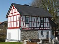
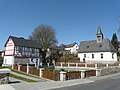
Attractions
- Evangelical church , built in 1696 as a successor to a former fortified church
- Backhaus Old village bakery with wood oven for traditional communal use
- Old school built in 1839 from rammed earth
- Extinguishing pond, the historical extinguishing water pond designated as a cultural monument in the center of the village between the bakery and the church
- Half-timbered houses , listed cultural monuments, some from the 17th century
- Court linden tree in Usinger Strasse at the exit of the village to Kröffelbach

The Protestant Church
The bakery
The quenching pond

The judicial linden tree


.jpg)
Web links
- Oberquembach district on the website of the municipality of Schöffengrund.
- Schöffengrund Oberquembach. Local history, information. In: www.oberquembach.de. Club community Oberquembach
- Oberquembach, Lahn-Dill district. Historical local dictionary for Hessen. In: Landesgeschichtliches Informationssystem Hessen (LAGIS).
- Literature on Oberquembach in the Hessian Bibliography
Individual evidence
- ↑ a b c d Oberquembach, Lahn-Dill district. Historical local dictionary for Hessen. (As of May 25, 2018). In: Landesgeschichtliches Informationssystem Hessen (LAGIS).
- ↑ Information sheet of the community of Schöffengrund from 2003, page 29 (PDF).
- ^ Federal Statistical Office (ed.): Historical municipality directory for the Federal Republic of Germany. Name, border and key number changes in municipalities, counties and administrative districts from May 27, 1970 to December 31, 1982 . W. Kohlhammer GmbH, Stuttgart / Mainz 1983, ISBN 3-17-003263-1 , p. 380 .
- ^ Michael Rademacher: German administrative history from the unification of the empire in 1871 to the reunification in 1990. State of Hesse. (Online material for the dissertation, Osnabrück 2006).
- ↑ Wilhelm von der Nahmer: Handbuch des Rheinischen Particular-Rechts: Development of the territorial and constitutional relations of the German states on both banks of the Rhine: from the first beginning of the French Revolution up to the most recent times . tape 3 . Sauerländer, Frankfurt am Main 1832, OCLC 165696316 , p. 428 ( online at google books ).
- ↑ “Richtlinde in Oberquembach” in: Courts in Hessen, in LAGIS
- ↑ "Linde von Oberquembach" in the tree register at www.baumkunde.de