
Kraftsolms
|
Kraftsolms
Municipality Waldsolms
Coordinates: 50 ° 27 ′ 22 ″ N , 8 ° 27 ′ 25 ″ E
|
|
|---|---|
| Height : | 203 m above sea level NHN |
| Area : | 5.53 km² |
| Residents : | 855 (Jan 1, 2008) |
| Population density : | 155 inhabitants / km² |
| Incorporation : | December 31, 1971 |
| Postal code : | 35647 |
| Area code : | 06085 |

Kraftsolms is a district of the central Hessian community Waldsolms in the southern Lahn-Dill district .
geography
The place is in the Solmsbachtal of the eastern Hintertaunus . Kraftsolms is also located in the Taunus Nature Park . The village is the northernmost part of Waldsolms and is surrounded by dense forests up to the east side. The highest point at Kraftsolms is the Buhlenberg at 363 meters above sea level.
Neighboring towns are Möttau (west), Niederquembach (north-west), Oberquembach (north), and Kröffelbach (south-east).
history
.jpg)
The origin of the name can be clearly derived from the Solmsbach, which is also the namesake of the Counts of Solms and several neighboring towns. The village is first mentioned in 1319 as a Craftsolmese . As early as 1395 Kraftsolms had its own church with a branch in Oberquembach and belonged to the Quembach court , which finally passed to the Solms counts in 1429 and 1462.
In 1440 a forest smithy near Kraftsolms is mentioned, which has existed for a long time, and later also a blast furnace hut (before 1586). The smelting of iron ore flourished for a long time, favored by the location on Hessenstrasse .
Kraftsolms belonged to the Solms office of Braunfels for a long time and later to the Prussian mayor's office of Braunfels . It was not until 1841 that the town became part of the Schöffengrund mayor's office .
Territorial reform
As a result of the Hessian regional reform , with effect from December 31, 1971, the independent municipality of Kraftsolms merged with another five municipalities to form the new large municipality of Waldsolms.
Territorial history and administration
The following list gives an overview of the territories in which Kraftsolms was located and the administrative units to which it was subordinate:
- before 1806: Holy Roman Empire , Principality of Solms-Braunfels , part of the County of Solms , Braunfels office
- from 1806: Duchy of Nassau , Amt Braunfels
- 1816: Kingdom of Prussia , Rhine Province , Region of Koblenz , county Braunfels
- from 1822: Kingdom of Prussia, Rhine Province, Koblenz District, Wetzlar District
- from 1866: North German Confederation , Kingdom of Prussia, Rhine Province, Koblenz District, Wetzlar District
- from 1871: German Empire , Kingdom of Prussia, Rhine Province, Koblenz District, Wetzlar District
- from 1918: German Empire, Free State of Prussia , Rhine Province, Koblenz District, Wetzlar District
- from 1932: German Empire, Free State of Prussia, Province of Hessen-Nassau , Administrative Region of Wiesbaden , District of Wetzlar
- from 1944: German Empire, Free State of Prussia, Nassau Province , Wetzlar District
- from 1945: American zone of occupation , Greater Hesse , Wiesbaden district, Wetzlar district
- from 1949: Federal Republic of Germany , State of Hesse , Wiesbaden district, Wetzlar district
- from 1968: Federal Republic of Germany, State of Hesse, administrative district Darmstadt , district of Wetzlar
- on December 31, 1971 Kraftsolms was incorporated as a district of the newly formed community Waldsolms.
- from 1977: Federal Republic of Germany, State of Hesse, Darmstadt administrative district, Lahn-Dill district
- from 1981: Federal Republic of Germany, State of Hesse, Gießen administrative district , Lahn-Dill district
population
Population development
| Kraftsolms: Population from 1834 to 1971 | ||||
|---|---|---|---|---|
| year | Residents | |||
| 1834 | 367 | |||
| 1840 | 421 | |||
| 1846 | 457 | |||
| 1852 | 443 | |||
| 1858 | 409 | |||
| 1864 | 435 | |||
| 1871 | 426 | |||
| 1875 | 438 | |||
| 1885 | 443 | |||
| 1895 | 430 | |||
| 1905 | 418 | |||
| 1910 | 457 | |||
| 1925 | 494 | |||
| 1939 | 560 | |||
| 1946 | 735 | |||
| 1950 | 781 | |||
| 1956 | 756 | |||
| 1961 | 769 | |||
| 1967 | 786 | |||
| 1971 | 854 | |||
| Data source: Historical municipality register for Hesse: The population of the municipalities from 1834 to 1967. Wiesbaden: Hessisches Statistisches Landesamt, 1968. Other sources: | ||||
Religious affiliation
Source: Historical local dictionary
| • 1834: | 367 Protestant residents, 10 Mennonites and 29 Jews |
| • 1961: | 667 Protestant (= 86.74%), 83 Catholic (= 10.79%) residents |

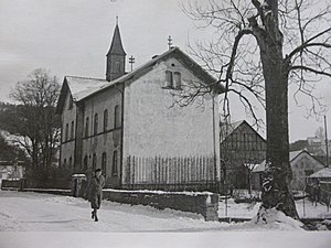
Historic bakery of the Schmiedenhof in Kraftsolms

Historical fair photo, villagers in front of the former restaurant zum Adler, Wehrstraße 2
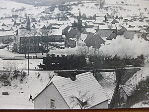
Kraftsolms 1950
Old school in Kraftsolms 1952


Cultural monuments

Transport and infrastructure
The L 3053 runs through the village along the Solmsbach valley coming from Braunfels-Neukirchen via Brandoberndorf to Butzbach . In addition, the L 3054 runs from Möttau , where it branches off from the federal highway 456 , to Schöffengrund and Hüttenberg . From 1912 to 1985 Kraftsolms also had its own rail connection with a stop at the Solmsbachtalbahn from Grävenwiesbach to Wetzlar, which has since been dismantled.
Kraftsolms has a volunteer fire brigade , a local court and a village community center .
Web links
- Kraftsolms on the website of the municipality of Waldsolms
- Kraftsolms, Lahn-Dill district. Historical local dictionary for Hessen. In: Landesgeschichtliches Informationssystem Hessen (LAGIS).
- Literature on Kraftsolms in the Hessian Bibliography
- State Office for the Preservation of Monuments Hesse (ed.): Complete system Ortskern Kraftsolms In: DenkXweb, online edition of cultural monuments in Hesse
Individual evidence
- ↑ a b c d Kraftsolms, Lahn-Dill district. Historical local dictionary for Hessen. (As of May 25, 2018). In: Landesgeschichtliches Informationssystem Hessen (LAGIS).
- ^ Federal Statistical Office (ed.): Historical municipality directory for the Federal Republic of Germany. Name, border and key number changes in municipalities, counties and administrative districts from May 27, 1970 to December 31, 1982 . W. Kohlhammer GmbH, Stuttgart and Mainz 1983, ISBN 3-17-003263-1 , p. 380 .
- ^ Michael Rademacher: German administrative history from the unification of the empire in 1871 to the reunification in 1990. State of Hesse. (Online material for the dissertation, Osnabrück 2006).
- ↑ Wilhelm von der Nahmer: Handbuch des Rheinischen Particular-Rechts: Development of the territorial and constitutional relations of the German states on both banks of the Rhine: from the first beginning of the French Revolution up to the most recent times . tape 3 . Sauerländer, Frankfurt am Main 1832, OCLC 165696316 , p. 250 ( online at google books ).