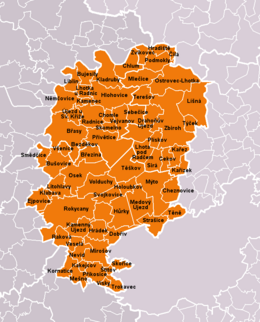
Okres Rokycany
| Okres Rokycany | |
|---|---|
| Kraj | Plzeňský kraj |
| surface | 575.11 km² |
|
Inhabitants • Population density |
48,966 ( January 1, 2019 ) 81 inhabitants / km² |
|
Municipalities • of which cities • of which Městyse |
68 6 1 |
| LAU 1 | CZ0326 |
|
Vehicle registration number (issued until 2001) |
RO |

|
|
Okres Rokycany (German: Rokitzan District ) is located in the eastern part of Plzeňský kraj . The area is 575 km² on which around 46,000 people live in 68 municipalities, a third of them in the district town of Rokycany alone .
Some small-scale nature reserves have been declared in the district. In addition, you can also admire some sights, such as
- the technical monument Wasserhammer , built in 1505 and the Swedish bridge in Dobřív .
- The center of the town of Rokycany, declared a cultural monument, with many historical monuments such as the baroque market fountain (1827), the town hall with pictures by Alfons Mucha , the Gothic church of P. M Sněžné, built by J.Palliardi, the paleontological collection in the museum.
- the town of Radnice , which is closely related to the Rožmberk and Štemberk families and where the best-preserved synagogue in the district is located.
- Zbiroh with a Gothic castle that was converted into a Renaissance castle in 1594 .
- the Zbirožský potok and the Berounka river with the ruins of the Libštejn castle .
- the Křivoklátsko Biosphere Reserve .
Rokycansko is visited by 21,000 people annually, half of them are foreigners who stay an average of 4.2 days in 39 accommodation establishments.
In addition to grain, hops, potatoes and fruit (apples) are grown, and cattle, pig and poultry farming play a role in livestock farming. Forestry and fishing are mostly operated by a few large companies. In the manufacturing sector, metal processing, mechanical engineering, bicycle construction, the manufacture of agricultural machines, automotive suppliers, the rubber and paper industry and food production predominate. Up until 1987, the mining of black coal and iron ores played a role in natural raw materials in the district . Today only building materials such as sand and gravel are mined. Of the approximately 12,000 employees, 48% work in industry, 11% in agriculture and just under 3% in construction. The average wage is 13,596 kroner and unemployment is 7.4%.
cities and communes
Bezděkov - Břasy - Březina - Bujesily - Bušovice - Cekov - Cila - Dobřív - Drahoňův Újezd - Ejpovice - Hlohovice - Holoubkov - Hradek - Hradiště - Hůrky - Cheznovice - Chlum - Chomle - Kakejcov - Kamenec - Kamenný Újezd - Kařez - Kařízek - Klabava - Kladruby - Kornatice - Lhota pod Radčem - Lhotka u Radnic - Liblín - Líšná - Litohlavy - Medový Újezd - Mešno - Mirošov - Mlečice - Mýto - Němčovice - Nevid - Osek - Ostrovec-Lhotka - Plískov - Podmokly - Příkosice - Přívětice - Radnice - Raková - Rokycany - Sebečice - Sirá - Skomelno - Skořice - Smědčice - Strašice - Svojkovice - Štítov - Těně - Terešov - Těškov - Trokavec - Týček - Újezd u Svatého Kříže - Vejvanov - Veselá - Vísky - Volduchy - Všenice - Zbiroh - Zvíkovec
Web links
- Homepage of ePUSA (cz)
Coordinates: 49 ° 49 ' N , 13 ° 40' E
