
Ottstedt am Berge
|
Ottstedt am Berge
Rural community of Grammetal
Coordinates: 51 ° 1 ′ 2 ″ N , 11 ° 12 ′ 49 ″ E
|
||
|---|---|---|
| Height : | 240 m above sea level NHN | |
| Area : | 5.11 km² | |
| Residents : | 241 (December 31, 2018) | |
| Population density : | 47 inhabitants / km² | |
| Incorporation : | December 31, 2019 | |
| Postal code : | 99428 | |
| Area code : | 036203 | |
Location of Ottstedt am Berge in Thuringia |
||

Ottstedt am Berge (officially: Ottstedt a. Berge ) is a district of the rural community Grammetal in the west of the Weimarer Land district in Thuringia .
geography
Ottstedt is about ten kilometers northeast of the state capital Erfurt and ten kilometers northwest of Weimar on the southwest slope of the Ettersberg , on which the Buchenwald concentration camp stood. The slope is made up of numerous paddocks and has been developed for tourism in recent years.
Neighboring communities and places are Hopfgarten , Niederzimmer , Ollendorf , Am Ettersberg and the city of Weimar .
history
The area around Ottstedt am Berge was already settled in the Neolithic Age. Prehistoric stone tools have been found along the erosion channel Gottesgraben on the western slope of Ettersberg between Ottstedt and the summit of the mountain. The first written mention as Odestat comes from the year 876, took place in the Ingelsheim protocol and took place in connection with the tithing dispute between the Archbishop of Mainz and the Fulda Monastery . Other names of the place were: Odenstat, Odenstet and Utstete. The connection with the Germanic god Odin is very close.
Until 1815, the border between the Electoral Mainz city of Erfurt (Amt Azmannsdorf) and the ducal Sachsen-Weimar ( Amt Weimar ) ran right through Ottstedt , dividing the place in two. With the Congress of Vienna , the Erfurt part with the Azmannsdorf office also came to the Grand Duchy of Saxony-Weimar-Eisenach ( Vieselbach office ), to whose Weimar administrative district the entire place belonged from 1850. In a village fire in 1820, 33 houses and most of the barns were destroyed, but the church remained intact.
In the years after reunification , the village was redeveloped. The measures covered u. a. the renovation of several farmsteads and properties in the lower and upper village, road and canal construction, the redesign of the village square and the monument. The baroque Ottstedt church was also affected by the construction work.
On December 31, 2019, the Ottstedt community merged with other communities to form the rural community of Grammetal. The Grammetal administrative community , to which all municipalities previously belonged, was dissolved at the same time.
politics
Former councilor
The local council in Ottstedt am Berge consisted of six council members, who were elected by proportional representation in the local elections on May 25, 2014 , and the honorary mayor as chairman.
The distribution of seats in the municipal council:
| choice | FDP | Citizen List | FFW | total |
|---|---|---|---|---|
| 2014 | 2 | 2 | 2 | 6 seats |
Former mayor
The last mayor of Ottstedt am Berge was Holger Haupt, who was elected on June 5, 2016.
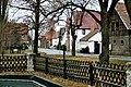
In the town

Village church
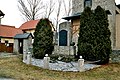
War memorial


Web links
Individual evidence
- ↑ Michael Köhler: Pagan sanctuaries. Jenzig-Verlag Köhler, Jena 2007, ISBN 978-3-910141-85-8 , p. 139.
- ^ Locations of the administrative district Weimar in the municipality register 1900 .
- ↑ Thuringian Law and Ordinance Gazette No. 11/2019 of October 18, 2019, p. 385 ff. , Accessed on January 8, 2020
- ^ The Regional Returning Officer Thuringia: Municipal elections 2014, city and municipal council elections .