
Penk (municipality of Reißeck)
|
Penk (village) locality cadastral municipality Penk |
|||
|---|---|---|---|
|
|||
| Basic data | |||
| Pole. District , state | Spittal an der Drau (SP), Carinthia | ||
| Judicial district | Spittal an der Drau | ||
| Pole. local community | Reisseck | ||
| Coordinates | 46 ° 54 ' N , 13 ° 16' E | ||
| height | 663 m above sea level A. | ||
| Residents of the village | 275 (January 1, 2020) | ||
| Building status | 101 (2001) | ||
| Area d. KG | 31.6 km² | ||
| Postcodes | 9816 Penk | ||
| Official website | |||
| Statistical identification | |||
| Locality code | 02097 | ||
| Cadastral parish number | 73309 | ||
| Counting district / district | Penk (20644 001) | ||
 A large part of the Penk cadastral community as seen from the Zwenberg : left the Möll villages Penk and Litzldorf , right Kohlstatt and Napplach (view south out of the valley) |
|||
| Source: STAT : index of places ; BEV : GEONAM ; KAGIS | |||

Penk is a village in the Mölltal in Upper Carinthia , and a locality and cadastral municipality of the municipality of Reißeck in the Spittal an der Drau district in Carinthia .
geography
The place Penk is about 25 kilometers northwest of Spittal an der Drau and the Millstätter See , at 663 m above sea level. A. left (north) of the Möll at the foot of the Kampleck ( 2523 m above sea level ) and its valley shoulder, the Zwenberg .
The village also includes the village of Kohlstatt , the Kirchheimer individual site , the Mölltheuer ruins and the Strumitzenalm . The village has about 100 buildings with around 320 inhabitants.
The cadastral community of Penk includes several localities: Napplach , Kohlstatt, Penk, Litzldorf , Gappen , Zwenberg and Moos . Together they have about 800 inhabitants on 31.6 km². Napplach and Kohlstatt lie south of the Möll, Litzldorf, Zwenberg, Gappen and Penk on the northern side. The cadastral area then also includes - except for the south-east slopes at the valley entrance, which form the Pfaffenberg of the municipality of Obervellach - the entire Zwenberg valley , which extends north-east into the Reisseck group , to Gamolnigspitze ( 2788 m above sea level ), Riekenkopf ( 2898 m above sea level ) above sea level ), Tristenspitz ( 2930 m above sea level ) and Groneck ( 2691 m above sea level )
For Zählsprengel Penk then includes the community Teuchl , which includes about 350 buildings with about 900 inhabitants.
- Neighborhoods and cadastral communities
|
KG Pfaffenberg (municipality of Obervellach )
|
Zwenberg |
|
|
KG Obervellach (district of Obervellach)
|
.svg)
|
|
|
KG Teuchl
|
KG Zandlach
|
history

Penk was first mentioned as Pench in a deed of donation in 1234, and the Mölltheuer castle ruins come from the same time . The Catholic parish church, St. Nicholas, is located in the village of Penk . It was built in the 15th century and modified in 1714, 1766 and 1808.
Penk was a separate municipality until 1973, when the municipality of Reißeck was founded as part of a municipality merger in Carinthia ( municipality reform 1973 ) from Penk, Kolbnitz and Mühldorf , which Mühldorf left again in 1992.
Transport and infrastructure

The Danielsberg and Teuchl can be reached from Penk . There is also a Penk stop of the Tauernbahn , below Zwenberg . It can be reached via Gappen or on foot via a path directly from Penk. Today the station is only used by around four trains per working day; with the timetable change in December 2019, these last passenger stops will also be omitted.
There is a primary school in Penk. It is attended by around ten students.

The cemetery
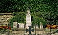
The war memorial in Penk
.jpg)
.jpg)
.jpg)
A beautiful hiking route leads into the Zwenberger Tal, but the end of the valley is impassable. The Reißeckhöhenweg only passes the Penker area at a higher altitude (from the mountain station of the Reißeckbahn north-west in the section Zwenberger Scharte - Zwenberger Törl).
In between are Lower Zwenberger Lake ( 2229 m above sea level. A. ) and Upper Zwenberger Lake ( 2501 m above sea level. A. ) and numerous other small cirque lakes .
Web links
Individual evidence
- 20644 - Reißeck. Community data, Statistics Austria .

Parts of the municipality: Kolbnitz | Penk | Teuchl
Cadastral communities: Kolbnitz | Penk | Teuchl | Zandlach
Localities: Gappen | Hattelberg | Litzldorf | Mitterberg | Moss | Napplach | Oberkolbnitz | Penk | Polan | Preisdorf | Rottau | Sandbichl | Teuchl | Drafts | Lower Kolbnitz | Zandlach | Zwenberg
Villages: Kohlstatt • Napplach • Oberkolbnitz • Penk • Unterkolbnitz • Zandlach | Rotten: Gappen • Litzldorf • Preisdorf • Rottau | Settlements: Polan • Sandbichl • Tratten | Scattered houses: Hattelberg • Mittelberg • Moos • Roßwiese • Teuchl • Zwenberg | Other locations: Mölltheuer ruins • Zandlacher hut
Counting area: Kolbnitz adTauernbahn | Penk