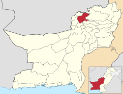
Pishin (District)
| Pishin District | |
| State : |
|
| Province : | Balochistan |
| Seat : | Pishin |
| Coordinates : | 30 ° 40 ′ N , 66 ° 50 ′ E |
| Area : | 7th 819 km² |
| Residents : | 736,481 (2017) |
| Population density : | 94 inhabitants per km² |
| Time zone : | PST ( UTC + 5 ) |

|
|
The Pishin District is an administrative district in Pakistan in the Balochistan Province . The seat of the district administration is the city of Pishin .
The district has an area of 7819 km² and 736,481 inhabitants according to the 2017 census. The population density is 94 inhabitants / km².
geography
The district is located on the north of the Balochistan Province, which is in the west of Pakistan. Much of Pishin consists of rough, mountainous and difficult to access terrain.
climate
The climate in the Killa Abdullah District is generally dry and temperate. The climate is particularly suitable for the growth of fruits, e.g. B. apples, apricots, peaches, plums, grapes, cherries and vegetables such as potatoes, onions, tomatoes.
history
The modern district was created in 1994 from parts of Quilla Abdullah .
Administrative division
The district is administratively divided into four tehsil :
Demographics
Between 1998 and 2017, the population grew by 3.58% annually. Around 18% of the population live in urban regions and around 82% in rural regions. There are 379,122 men, 357,356 women and 3 transgender people in 128,080 households, which results in a gender ratio of 106.1 men per 100 women and thus a common surplus of men for Pakistan. Over 90% of the population speak Pashtun . The main tribes of the district are the Kakar, Tarin, Syed and Achakza.
The literacy rate in the years 2014/15 among the population aged 10 and over was 49% (women: 25%, men: 70%).
| year | population |
|---|---|
| 1998 | 376.728 |
| 2017 | 736.481 |
economy
Most of the workers are employed in agriculture. The main crops are wheat, barley, corn, potatoes, grapes, apples, apricots and peaches, which are grown in the valleys. Sheep and goats are also kept.
Web links
Individual evidence
- ↑ a b DISTRICT WISE CENSUS RESULTS CENSUS 2017. August 29, 2017, accessed May 30, 2019 .
- ↑ Pakistani Districts wise Population Census 2017. Accessed May 30, 2019 .
- ^ Pakistan Bureau of Statistics (2016). Pakistan Social and Living Standards Measurement Survey 2014-15. Government of Pakistan, accessed June 29, 2019 .
