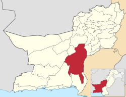
Khuzdar (District)
|
Khuzdar district ضلع خضدار |
|
| State : |
|
| Province : | Balochistan |
| Seat : | Khuzdar |
| Coordinates : | 27 ° 10 ′ N , 66 ° 20 ′ E |
| Area : | 35,380 km² |
| Residents : | 802.207 (2017) |
| Population density : | 23 inhabitants per km² |
| Time zone : | PST ( UTC + 5 ) |

|
|
The Khuzdar District ( Balochish and Urdu ضلع خضدار) is an administrative district in Pakistan in the Balochistan Province . The seat of the district administration is the city of Khuzdar .
The district has an area of 35,380 km² and according to the 2017 census 802,207 inhabitants. The population density is 23 inhabitants / km².
geography
The district is located to the east of the Balochistan Province in western Pakistan and borders the much more populous Sindh Province . The topography is partly shaped by mountains and the height above mean sea level varies between 64 and 2852 meters.
climate
There is a semi-arid climate with warm summers and mild winters and annual precipitation of around 300 mm.
| Khuzdar district | ||||||||||||||||||||||||||||||||||||||||||||||||
|---|---|---|---|---|---|---|---|---|---|---|---|---|---|---|---|---|---|---|---|---|---|---|---|---|---|---|---|---|---|---|---|---|---|---|---|---|---|---|---|---|---|---|---|---|---|---|---|---|
| Climate diagram | ||||||||||||||||||||||||||||||||||||||||||||||||
| ||||||||||||||||||||||||||||||||||||||||||||||||
|
Climate in Khuzdar in the Khuzdar district (2008)
Source: Karachi Regional Meteorological Center
|
|||||||||||||||||||||||||||||||||||||||||||||||||||||||||||||||||||||||||||
history
The relatively central location at the junction of the streets of Multan in Punjab , Makran on the Arabian Sea and Kandahar in southern Afghanistan made Khuzdar a strategically important location during the Islamic invasion of India. In 664 AD, Khuzdar was conquered by the Arabs. In the following centuries the area was under the rule of various Muslim dynasties ( Ghaznavids , Ghurids ) and later the Mughal Empire . After the end of the Mughal Empire in the 19th century, Khuzdar was under indirect British rule as part of British India. After the end of British rule in 1947, it became part of Pakistan and was administratively organized as the Kalat District . On March 1, 1974, the new Khuzdar district was created from parts of the Kalat district. In November 1992 the new district Awaran was again formed from parts of Khuzdar.
Administrative division
The district is administratively divided into five tehsil :
Demographics, ethnic groups
The Baluch make up the largest part of the population. The main tribes in the district are the Zehri, Sumalani, Mengal, Kalandrani, Mohammad Hasni, Sajidi, Bizenjo, Nichari, Qambrani, Pandrani, Mirwani, Rekizai, Gurganari, Jattak, Rodeni and Sasoli. Minority languages are Brahui and Sindhi .
Between 1998 and 2017 the population grew by 3.49% annually. Around 35% of the population live in urban regions and around 65% in rural regions. 421,268 men and 380,939 women live in 120,405 households, which results in a gender ratio of 110.6 men per 100 women and thus a common surplus of men for Pakistan.
The literacy rate in the years 2014/15 among the population aged 10 and over was 45% (women: 26%, men: 60%).
| year | population |
|---|---|
| 1972 | 146.207 |
| 1981 | 276,449 |
| 1998 | 417.466 |
| 2017 | 802.207 |
Web links
Individual evidence
- ↑ a b DISTRICT WISE CENSUS RESULTS CENSUS 2017. August 29, 2017, accessed May 30, 2019 .
- ↑ Pakistani Districts wise Population Census 2017. Accessed May 30, 2019 .
- ↑ a b c d e District Development Profile 2011: Khuzdar. (pdf) Planning & Development Department of the regional government of Balochistan in Quetta in cooperation with UNICEF, accessed on July 22, 2019 (English).
- ^ Pakistan Bureau of Statistics (2016). Pakistan Social and Living Standards Measurement Survey 2014-15. Government of Pakistan, accessed June 29, 2019 .


