Point Nepean National Park
| Point Nepean National Park | ||
|---|---|---|
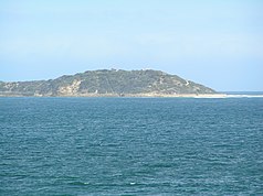
| Point Nepean from Queenscliff | ||
|
|
||
| Location: | Victoria , Australia | |
| Specialty: | Old quarantine station, military ruins | |
| Next city: | Portsea | |
| Surface: | 2.95 km² | |
| Founding: | 1988 | |
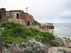
| Ruins of the engine house at Point Nepean | ||
The Point Nepean is a national park in the far south of the Australian state of Victoria , 60 kilometers south of the center of Melbourne . Point Nepean is the southernmost point of The Rip , a dangerous sea area at the entrance to Port Phillip , and the western end of the Mornington Peninsula . It was named after the British politician and colonial administrator Sir Evan Nepean (1751-1822). The tip of the peninsula forms the national park of the same name, while the coastline belongs to the Port Phillip Heads Marine National Park . Cheviot Beach is also located at Point Nepean. The SS Cheviot ran aground there in 1887 and on December 17, 1967 the Australian Prime Minister Harold Holt disappeared there without a trace. He probably drowned.
history
Evidence of Aboriginal colonization in this area can be traced back 40,000 years. Point Nepean was a birthplace for the Bunurong women . In the national park there are 70 designated archaeological sites of Aboriginal culture.
Limestone has been quarried from the coastal cliffs since the first days of European settlement and in 1840 two limestone quarries were established. The quarantine station at Point Nepean opened in 1852, making it the second oldest in Australia. It contains the oldest buildings erected in Australia for this purpose. Four of the main hospital buildings (built in 1857) are 16 years older than the oldest such buildings in Sydney . The quarantine station operated until 1980.
The first post office at Point Nepean opened on April 1, 1859, but closed again in 1865. The first military fortifications began in 1878. Gun batteries were built at Fort Nepean in 1886 and at Eagles Nest in 1888. In 1911 a gun battery was built at Fort Pearce . After the coastal artillery was dismantled after World War II , the buildings were used by an Officer Cadet School and the School of Army Health from 1951 to 1985 .
Land sales and national park
Parts of Point Nepean were declared a national park in 1988. The Australian federal government offered the land for sale to the state of Victoria in 1998 and again in 2001, but Victoria turned down the offers.
In 2002 the Ministry of Defense proposed the sale of 311 hectares of land for civil use and wanted to keep 1.6 hectares because the earth was contaminated and live artillery ammunition was still stored there. The sales plans were given up again in 2003 after violent protests by the population. In 2004, 90 hectares of land were given up by the Department of Defense to the state-owned Point Nepean Community Trust , which managed the former quarantine station until the land was transferred to the Victoria government on June 8, 2009. The Australian state also signed 205 hectares of bushland - formerly in the pivoting range of the gun batteries - to Parks Victoria and the remaining 17.6 hectares to the Mornington Peninsula Shire for municipal use.
The former quarantine station was reopened to the public in December 2009 as part of the national park drug group.
Military ruins
The following ruins from the time of the military use of Point Nepean can still be seen in the national park today (the most important ruins are indicated in italics):
- Gun Junction - Ruins of a gun battery and sentry box
- Norris Barracks - consists of buildings from the former quarantine station
- 25 m gun slewing range
- Cattle Jetty Ruins (1879) - lookout
- Point Nepean Cemetery (1854–1952)
- Cheviot Hill
- Gun battery from the Second World War, with a lookout
- Machine gun stand
- Eagles Nest
- Fort Pearce
- Pearce barracks
- Gun posts
- Fort Nepean
- historical protective wall
- 8 gun stands
- Machine house
- historical gun barrels
- underground tunnels
environment
The coasts at Point Nepean consist of reef platforms, which are dry at low tide and provide habitat for many invertebrates, and underwater reefs with various species of fish, invertebrates and crustaceans such as sea squirts , sponges and moss animals .
Web links
swell
Port Phillip Heads Marine National Park Management Plan . Parks Victoria. Melbourne (2006). ISBN 0-7311-8349-5


