
Roman manor of Büßlingen

The Roman estate of Büßlingen is a restored and reconstructed villa rustica ( Roman estate) from the first century AD, which existed at least into the third century.
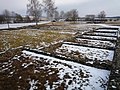
The complex comprises nine excavated buildings on an area of 5.4 hectares . It is located south-southeast of Büßlingen , a district of Tengen in the Baden-Württemberg district of Konstanz in Germany .
After the Villa rustica von Meßkirch , it is the largest known courtyard complex of its kind in southern Germany and also the only one whose buildings, determined by aerial archeology, have been completely excavated. Today it is an open-air museum .
Location and surroundings
Historical
The estate of Büßlingen belonged to the Roman province Germania superior and was located between the Vici Schleitheim ( Iuliomagus ) in the southwest and Orsingen in the east, each 15 kilometers away. A little further to the southeast were the Vici Stein and Eschenz ( Tasgetium ). The distance to the Roman border forts at Hüfingen in the northwest and Tuttlingen in the southeast was about 24 kilometers . In the immediate vicinity of the manor there were Roman settlements or manors in Storzeln , Binningen , Tengen , Beuren and Watterdingen within a distance of about 1.5 kilometers . To the west of the site are the Gewann "Hochstraße" and a street called "Hochstraße". Both could be indications of a Roman road passing by , but this could not be proven.
today
The remains, which the archaeological monument represent, are on a slightly inclined to the south grounds of the district "Binningen" the city of Tengen in the western part of the Hegau at an altitude of 515 m above sea level. NHN . The farm is exactly in the “Lohgaß” area. The site is about one kilometer to the west from the federal highway 314 and two kilometers to the east from the German-Swiss border. Closer larger towns are Hilzingen on the German side (eight kilometers) and Thayngen (5.5 kilometers) on the Swiss side . The Roman road Neckar-Alb and the Heidelberg-Black Forest-Bodensee-Weg lead past the area. To the east of the area runs a brook in the “Zeltengraben”, to which there is a “canalized” inlet to the southeast from the Römerhof. To the north of the Zeltengraben lies the “Lohrenwald”. The farm lies on a plain sloping slightly to the south, which connects to the cut valley of the beavers in the west .
Excavations
The first finds on the grounds of the Büßlinger Gutshof were made at the turn of the 19th and 20th centuries during drainage work. The first publication of relief sigillata fragments, presumably from 1900, was published in 1913 by Otto Fritsch. Due to land consolidation activities that affected the area, excavations became necessary and began in 1976. In total, around a third of the 5.4 hectare area was uncovered and a sixth of the site was extensively investigated. The buildings were excavated in the planum , and profiles were rarely created. Areas between the buildings were opened up with the excavator. The excavations, reconstructions and developments with paths were completed in 1982.
The client of the excavations, led by the district archaeologist Jörg Aufdermauer from Constance , was the city of Tengen, which intended to turn the area into an open-air museum. The work was supported by the State Monuments Office and State Office for Land Consolidation Baden-Württemberg as well as the employment office, which provided an average of twelve workers. There was therefore a lack of competent employees, which meant that the requirements for a modern excavation could not be met.
The excavated finds can be viewed in the Archaeological Hegau Museum in the city of Singen . These include numerous ceramic bowls , the upper part of an amphora , fired roof tiles and a hypocaust pillar. In addition, there were metal components of a bolt lock, a knife, an iron fork, a pair of scissors, a sickle fragment , a spout scraper, a tool for woodworking, three stylus (stilus) and broken glass. In addition to a belt buckle two bronze were fibula with enamel ornaments (between 150 and 200 n. Chr.) And such a place without decorations. An Alemannic iron cross was also found on the site. A copy of the coin treasure from building 8 is on display in the museum.
History of the manor
Roman cultivation
To date the founding of the farm , a terra sigillata bowl serves as evidence, which is ascribed to the late 1st century . Based on comparisons with similar finds, for example from Rottenburg ( Sumelocenna ) and the forts in Heilbronn-Böckingen and Bad Nauheim , a founding year between 75 and 80 is assumed. Since some of the clay potteries are also of Celtic origin, Romans and Celts probably lived together on the farm . In the early years, the system was probably built in wood, which was then replaced by stone construction over the years, but there are no reliable finds in Büßlingen. An extension in stone construction can only be assumed from the middle of the 2nd century , this at least suggests parallels to villas in the area.
The most recent coin finds on the site were made in the wall of Building 8. They were collected and left here by a resident between 240 and 259, a total of 100 coins. The treasure represented one and a half times the monthly wage of a simple Roman soldier . One reason for leaving it in the wall could be the southern advance of the Alemanni in the years after 260 AD. The yard was possibly destroyed and the owner prevented from getting the coins out of the hiding place in time. The earliest end of the estate could have been 263, as a coin, an Antoninian , of the treasure was minted in 262 or mid-263 at the earliest. However, the attribution of the coin to the treasure is not certain. The approximately 190 years of Roman use correspond to between six and seven generations.
After Roman times
What happened after the secured Roman settlement activity on the manor is considered unsecured. If the Romans had left the court, extensive household items would have been left behind. There is also evidence that both the Alemanni and the Romans used the farm in the 3rd and 4th centuries. The most important evidence of use in the 4th century is a bow-button primer . Other late Roman finds are easy to compare, but cannot be clearly assigned to a century. In addition, there were signs of post construction in the inner courtyard of the main building (Building 1), which can be counted in the early migration period .
None of the finds on the site proves that settlement activity lasted for a long time. They only allow the assumption that the villa was either used as a Roman burial place or that the Alemanni continued to use it. They could have taken over the existing Roman agricultural infrastructure, but the residential buildings were probably not used.
use
The soil science assessment shows a negative pseudo-gleying in the Tengen area . These soils are characterized by a lack of oxygen and a wealth of clay and nutrients. This causes the vegetation to become grassy and weed, as backwater cannot drain off. In addition, the vegetation period is shortened at the heights of the Hegau volcanoes and the Randen . As a result, the land around the manor was not suitable for the cultivation of crops , so the main focus of use may have been on livestock farming . Bones found on the farm show that there were a large number of oxen , an indication of the use of carts. The pig bones found show older, female animals that would have been suitable for breeding young animals. According to estimates, 40 to 50 people could have lived and worked in the courtyard in around 1230 square meters of floor space in four buildings. The size of the cultivated area would have been up to 100 hectares and could have fed around 50–60 cattle , 100 sheep or goats and 50 pigs . At this size, overproduction would have been expected, which is why the farm could have served as a supply company for the cities of Tasgetium or Iuliomagus .
Construction engineering
Masonry
The same wall technology made from cold-age rubble was used for all the excavated buildings . After measuring a rectangular ground plan, the workers dug foundation trenches that followed the natural slope of the terrain. Depending on the function of the building, these were between 40 and 120 centimeters deep and between 60 and 120 centimeters wide. Then they were filled with Hegau basalts and phonolites , which resulted in the so-called " seepage ". It guaranteed the infiltration of rainwater. The foundation walls that corresponded to the width of the trench were then put in place. The double row and -lagigen walls were made of sand-lime bricks and isolated from shell fragments and conglomerate blocks . The connection between the mostly unworked stones was probably made by lime mortar . Only the corner stones were sometimes hewn.
The walls, which are about 10 cm narrower, were placed on the foundation walls, which were in turn two rows and consisted of unhewn stones. Sometimes up to five layers were preserved. The interior was filled with stones and lime mortar. The difference was mostly visible in the interior or covered with sloping stones on the outside.
walls
No plastering could be proven for the outer walls, the grouting is missing on the rising masonry. The inside walls of the main building and the temple have been plastered with white lime mortar according to the indications. In a few places there were remains of geometric paintwork made of red and yellow stripes.
doors and windows
Only in building 4 were the thresholds of a 90 cm wide wooden door found. In the temple there were references to an entrance lined with limestone slabs. There are no indications of entrances in the other buildings. The findings on windows allow only a few conclusions about the type of window. Only the remains of window panes and a window grille remained.
roofs
Overall, only a few roof tile fragments were secured during the excavation (143 ). Tegulae were available in two different sizes, with the larger version measuring 35 by 32 centimeters. The small version was much narrower with the same length: between 15 and 19 cm. At a thickness of 2 cm, the imbrices found had a width of 16 cm and a height of 6.5 cm. For buildings 1–4 and 7, the roof tile fragments could be clearly identified. Only fragments of bricks were found in the rest of the buildings.
Floors

Remnants of screed floors have been found in some buildings . The screed consisted of a mixture of sandstone and limestone interspersed with brick chippings. It was ten centimeters thick and laid on an equally thick layer of rubble. The sub-floors of the underfloor heating and the swimming pool were of the same type. In building 4 there was a secondary burned rammed earth floor .
Four rooms were equipped with underfloor heating typical of the time ( hypocaust ). A cavity was left under the actual floor, which was built on at regular intervals with stone pillars ( hypocaust pillars ) supporting the floor . In Büßlingen two complete pillars with a length of 38 and 60 cm were recovered. On top of this, almost square brick slabs ( suspension slabs ) were laid, which formed the base for the floor layer of lime mortar. A heating duct, which conducted air into the cavity, heated the floor with lighting. In continuous operation, a floor temperature of up to 30 ° C could be achieved. Angular clay tubes ( tubules ) were used to dissipate smoke and heat into the stone core of the walls, which at the same time led to an additional, slight warming of the house wall. Tubules could be secured that had a cavity of eight by eight centimeters. The furnace used for heating was clad with sandstone slabs, as was the heating duct.
The attachment
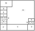
The excavated area has an almost trapezoidal floor plan, as it is typical for a litter yard and includes nine proven buildings. The stable (building 9) and the slaughterhouse (building 4) were covered again after the excavation work, but a reconstruction is planned. A stone wall with the approximate dimensions 190 × 250 meters surrounded the area. A three-meter-wide farm path paved with stone slabs, which runs towards the main building from the east, was excavated, but was not reconstructed. Overall, the main features of the buildings have been reproduced using modern methods and the original parts have been completed.
Residential building
Residential building - View of the house via room 10
Floor plan of the residential building


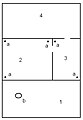
The south-facing residential building (Building 1) is located in the central part of the site and has the basic dimensions 35 × 40 meters. During the excavations, the seepage, parts of the foundation wall and in the northern section up to two layers of the rising masonry were found. The one-story house was divided into ten rooms. To the left and right of the entrance hall (room 1) were two, probably one-story corner towers (room 2,3). This was followed by two hypocaust-heated rooms (4, 5), which in turn were followed by the bedrooms and dining rooms (6–9). The house also had a store room (10). The uncovered 600 square meter inner courtyard (11) took up most of the house . The house entrances could not be reconstructed during the excavations.
In contrast to other, more luxurious Villae rusticae, the house in Büßlingen did not have a column-supported entrance hall in front of the house, but an entrance hall that was fully integrated into the house. The corner towers, which today only have their square outline, were probably not recognizable as such from the outside. The reason for that was missing in the manor house of the usual cellar, could at the partially close reaching to the surface backwater - horizon lie. This would probably have caused too much water to enter the cellar, at least periodically. The basement was replaced by a room with a mortar floor in the west corner of the house. Architectural peculiarities are a beveled uppermost stone layer of the foundation wall and a drainage ditch on the southwest side of the house. The former was for aesthetic reasons, the latter was due to the western weather conditions prevailing in this region. Therefore, it was concluded that the pent roof was sloping outwards .
Bathhouse
The bathhouse (building 3) is located on the south side, at the lowest point of the site and is over 200 square meters in size. The drainage, foundation wall and the lowest layer of the rising masonry remained from the building, as well as parts of the colored interior plastering and the brick covering of the cold water basin in fragmentary form. In total, the house was divided into six rooms, each with a 10 cm thick mortar floor underlaid with rolling stones. On the east side was the boiler room (5), which provided both the warm water and the heat for the underfloor heating. This could also be the reason for the poorly heated main building: In the cooler seasons, the residents probably spent more of their free time in the bathhouse, which is likely to be permanently heated.

Bathhouse - View of the house via room 2a
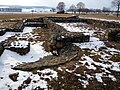
Bathhouse - View of the house from room 5
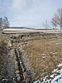
Drainage channel of the bathhouse
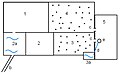
Floor plan of the bathhouse


In the course of the first century, a basic scheme had emerged for the process in a Roman bath. After changing clothes in the palaestra (room 1), the bather went to the cold water room (2), half of which consisted of the cold water pool ( piscina , room 2a). Then he switched to the sweat bath ( sudatorium , room 3) and from there either to the warm bathtub ( caldarium , room 3a) or the leaf bath ( tepidarium , room 4). The rooms for the lukewarm and warm bath were heated with the hypocaust. The water was heated in a metal kettle and fed into the basin through a lead pipe. The boiler was located directly on the heating line for the hot bath. How the water got to the bathhouse has not yet been clarified, but its process. There was a septic tank under the basins, from which a drainage channel led to the outside.
temple

The temple (building 2) is 25 meters southeast of the residential building and faces its entrance hall. At nine meters wide and 16 meters long, the temple is larger than most of the Roman temples of this type in Baden-Württemberg. The building of the type of prostylos was divided into two rooms, the sanctuary ( cella , about 96 sqm) and an entrance hall (about 54 sq m). During the excavations, the seepage and the foundation walls were found. Parts of the mortar floor of the innermost sanctuary and the entrance area could also be found. The roof over the open entrance hall was presumably supported by four pillars, but these were not preserved. What was noticeable about the building was the better construction in comparison with the other buildings. References to the deity worshiped here could not be found.
Farm buildings
The manor had a total of six farm buildings. These included a forge , a slaughterhouse , a stable and another three buildings, probably used as barns.

Schmiede - View over room 4 to the house
Floor plan of the forge


The forge (building 5) is a little west of the main house. From her seepage and large parts of the foundation walls as well as the beginning, rising masonry were preserved. Traces of fire and ash finds in the two central rooms (2,3) indicate that the building was used as a forge's house. The rest of the furnace were also found. Reddish traces of fire from the heat were found on the walls and corners of the rooms, so that several fireplaces can be assumed. A semicircular trail of fire in the clay floor of the eastern room, reaching 8 centimeters into the ground, indicates a larger furnace such as an iron melt. In the southern room (1) there is only a larger fireplace that could have belonged to a stove and remains of a mortar floor. From this, parts of the substructure and stone slab supports, which are also annealed, have been preserved. Next to it was a former grinding stone that might have served as a holder for a swivel arm. It could also be possible that the building was in use as a house in which the employees of the farm lived. Under the court blacksmith's shop, an older house was found that was probably used as a stable.
The slaughterhouse (building 4) is located at the easternmost point of the area. It has not yet been reconstructed, but animal bone finds in its vicinity suggest that it was used as a slaughterhouse. In addition, it could also be used as a gatehouse .
At the other end of the site, to the northwest, was the stable (building 9) of the courtyard. However, only the seepage was preserved, so that the actual function can only be assumed. The building is quite narrow and therefore rather elongated (in contrast to the more spacious barns). There would have been space for two rows of cattle boxes.

Barn (6)

Barn (7)

Barn (8)


To the south of the temple there were two barns (Buildings 6, 7) and another one (Building 8) to the northwest of the main house. Only the drainage of the former was preserved, but the larger floor plan suggests it was used as a warehouse. Parts of the foundation walls and the rising masonry of the third barn could also be found. The gold coins were found in a collapsed wall of a suspected extension.
Monument protection
The ground monument "Roman Manor of Büßlingen" is protected as a registered cultural monument in the sense of §2 of the Monument Protection Act of the State of Baden-Württemberg (DSchG) . Investigations and targeted collection of finds are subject to approval, and accidental finds are reported to the monument authorities.

literature
- Jörg Aufdermauer: A Roman estate in Büßlingen, Konstanz district . In: Ancient World , 12, 1981.
- Jörg Aufdermauer: A Roman estate in Tengen-Büsslingen, Constance district. In: Archeology of Switzerland 9, 1986, pp. 57–61.
- Karin Heiligmann-Batsch: The Roman manor near Büsslingen, district of Konstanz. A contribution to the settlement history of the Hegau . Theiss, Stuttgart 1997, ISBN 978-3-8062-1286-0 .
Web links
- Information on the “Römischer Gutshof Büßlingen” open-air museum on the city of Tengen's website
- Pictures from the excavations in 1976 (rows 1-4)
- Archaeological Hegau Museum on the website of the city of Singen
- Villa Rustica in Büßlingen on the website of the Roman road Neckar-Alb-Aare
Individual evidence
- ↑ Karin Heiligmann, Jürgen Hald: The Roman estate of Tengen-Büßlingen. (PDF; 3.0 MB) A small guide to the open-air facility. 2011, p. 2 , accessed July 19, 2013 .
- ↑ Karin Heiligmann-Batsch: The Roman estate near Büsslingen . Theiss, Stuttgart 1997, pp. 13, 15.
- ↑ a b ADAC City Atlas: Greater City and Community Atlas Lake Constance (Volume 63, 1: 20,000) . 3. Edition. ADAC-Verlag, Munich 2001, ISBN 978-3-8264-0952-3 .
- ^ Landesvermessungsamt Baden-Württemberg (ed.): Hiking map of the Black Forest Association "Sheet 10 - Hegau-Bodensee" (1: 50,000) . 1989.
- ↑ Compass hiking and biking map: Sheet 783 Hegau, Westlicher Bodensee (1: 50,000) .
- ^ Tengen mayor's office (ed.), Karin Heiligmann: Little Roman manor guide Büßlingen .
- ^ Tengen mayor's office (ed.), Karin Heiligmann: Little Roman manor guide Büßlingen .
- ↑ a b c Anneros Troll, Jürgen Hald: Time travel on Lake Constance. From the reindeer hunters to the Alemanni . Culturis, Steißlingen 2004, pp. 24-25.
- ↑ Karin Heiligmann-Batsch: The Roman estate near Büsslingen . Theiss, Stuttgart 1997, pp. 16-17.
- ^ City of Singen: The collection of the Hegau Archaeological Museum . Retrieved December 12, 2011.
- ↑ Karin Heiligmann-Batsch: The Roman estate near Büsslingen . Theiss, Stuttgart 1997, p. 95.
- ↑ Karin Heiligmann-Batsch: The Roman estate near Büsslingen . Theiss, Stuttgart 1997, p. 98.
- ↑ Karin Heiligmann-Batsch: The Roman estate near Büsslingen . Theiss, Stuttgart 1997, p. 54.
- ↑ Karin Heiligmann-Batsch: The Roman estate near Büsslingen . Theiss, Stuttgart 1997, p. 59.
- ↑ Karin Heiligmann-Batsch: The Roman estate near Büsslingen . Theiss, Stuttgart 1997, p. 98 ff.
- ↑ Karin Heiligmann-Batsch: The Roman estate near Büsslingen . Theiss, Stuttgart 1997, p. 15.
- ↑ Karin Heiligmann-Batsch: The Roman estate near Büsslingen . Theiss, Stuttgart 1997, p. 105.
- ↑ Karin Heiligmann-Batsch: The Roman estate near Büsslingen . Theiss, Stuttgart 1997, p. 108.
- ↑ Karin Heiligmann-Batsch: The Roman estate near Büsslingen . Theiss, Stuttgart 1997, p. 108f.
- ↑ a b Karin Heiligmann-Batsch: The Roman estate near Büsslingen . Theiss, Stuttgart 1997, pp. 45-46.
- ↑ a b Karin Heiligmann-Batsch: The Roman estate near Büsslingen . Theiss, Stuttgart 1997, pp. 46-47.
- ↑ Karin Heiligmann-Batsch: The Roman estate near Büsslingen . Theiss, Stuttgart 1997, p. 46.
- ↑ Karin Heiligmann-Batsch: The Roman estate near Büsslingen . Theiss, Stuttgart 1997, p. 42.
- ↑ Karin Heiligmann-Batsch: The Roman estate near Büsslingen . Theiss, Stuttgart 1997, p. 27.
- ↑ Albert Bittlingmaier: Old walls tell stories. August 22, 2008. Retrieved July 19, 2013 .
Coordinates: 47 ° 47 ′ 11.7 " N , 8 ° 42 ′ 16.2" E