Randolph (Vermont)
| Randolph | ||
|---|---|---|
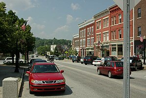
 Downtown Randolph |
||
| Location in Vermont | ||
|
|
||
| Basic data | ||
| Foundation : | October 2, 1780 | |
| State : | United States | |
| State : | Vermont | |
| County : | Orange County | |
| Coordinates : | 43 ° 56 ′ N , 72 ° 36 ′ W | |
| Time zone : | Eastern ( UTC − 5 / −4 ) | |
| Residents : | 4,778 (as of 2010) | |
| Population density : | 38.5 inhabitants per km 2 | |
| Area : | 124.1 km 2 (approx. 48 mi 2 ) of which 124.1 km 2 (approx. 48 mi 2 ) is land |
|
| Height : | 420 m | |
| Postal code : | 05060 | |
| Area code : | +1 802 | |
| FIPS : | 50-58075 | |
| GNIS ID : | 1462182 | |
| Website : | RandolphVT.GovOffice2.com | |
Randolph is a town in Orange County in the state of Vermont in the United States and with a population of 4,778 (according to the 2010 census), it is by far the largest parish in Orange County.
geography
Geographical location
Randolph is in southwest Orange County. The White River flows through the western part in a northerly direction and its tributaries through the eastern part in a southerly direction to flow into the White River at Royalton. There are only smaller lakes in the town area. The terrain is hilly without any major elevations. The highest point is the 575 m high Old Hurricane Hill . Randolph is located in central Vermont on a plateau of the Green Mountains , the so-called Upper Valley .
Neighboring communities
All distances are given as straight lines between the official coordinates of the places from the 2010 census.
- North: Northfield , 15 mi
- Northeast: Chelsea , 11 mi
- East: Fairlee 25 miles
- Southeast: Tunbridge , 9.3 mi
- South: Bethel , 7.5 miles
- Southwest: Proctor , 44.0 km
- West: Braintree , 7 miles
- Northwest: Warren , 15 mi
City structure
There are two main settlement centers in the town area: the Village Randolph and Randolph Center . Two historical settlement centers, East Randolph and West Randolph , no longer exist today.
climate
The mean mean temperature in Randolph is between −9.44 ° C (15 ° Fahrenheit ) in January and 18.3 ° C (65 ° Fahrenheit) in July. This means that the place is around 9 degrees cooler than the long-term average in the USA. The snowfall between mid-October and mid-May is more than two meters, about twice as high as the average snow depth in the USA. The daily sunshine duration is at the lower end of the range of values in the USA, between September and mid-December it is even significantly lower.
history
Proclaimed October 2, 1780, the new settlement land was sold on June 29, 1781 to a group of settlers from Hanover , New Hampshire . The constituent city assembly took place on March 31, 1783. A first meeting house , a community and prayer house, was built in 1792 and replaced by a new building in the same place in 1838. The town was primarily agricultural and produced, among many other raw materials, above all potatoes, oats, sheep and wool. Two inlets of the White River offered the possibility to build different watermills. On November 8, 1806, the - no longer existing - Orange County Grammar School (also: Randolph Academy ), the college of the county, was founded in Randolph Center and the schoolhouse was built the following year. Around 1840 it was noted that the school was very well stocked and that the library had 300 volumes.
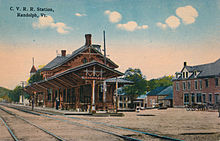
In 1848 the community was linked to the Windsor – Burlington railway line and had its own station. The line has been in operation to this day; however, passenger traffic was suspended for a few years. Today the Randolph station is served by a daily express train The Vermonter , which connects the place to Washington DC.
In addition to the usual small-scale agricultural industries that feed the majority of the town's population, Randolph is also an artistic center for the wider area. The Chandler Center for the Arts , a community-based art association, has existed in Randolph since 1907 as a concert hall and art gallery used building maintains and organizes performances and exhibitions all year round.
In the main settlement Randolph there is an Episcopal , a Methodist and a Roman Catholic church ; in addition, there is a United Church of Christ ward with an additional ward at Randolph Center . All types of schools up to high school are represented in town. A hospital ensures medical care for the wide area. The main traffic route is Interstate 89 , which crosses the town from north to south.
Population development
| Census Results - Town of Randolph, Vermont | ||||||||||
|---|---|---|---|---|---|---|---|---|---|---|
| year | 1700 | 1710 | 1720 | 1730 | 1740 | 1750 | 1760 | 1770 | 1780 | 1790 |
| Residents | 892 | |||||||||
| year | 1800 | 1810 | 1820 | 1830 | 1840 | 1850 | 1860 | 1870 | 1880 | 1890 |
| Residents | 1841 | 2255 | 2487 | 2743 | 2678 | 2666 | 2502 | 2829 | 2910 | 3232 |
| year | 1900 | 1910 | 1920 | 1930 | 1940 | 1950 | 1960 | 1970 | 1980 | 1990 |
| Residents | 3141 | 3191 | 3010 | 3166 | 3278 | 3499 | 3414 | 3882 | 4689 | 4764 |
| year | 2000 | 2010 | 2020 | 2030 | 2040 | 2050 | 2060 | 2070 | 2080 | 2090 |
| Residents | 4853 | 4778 | ||||||||
Economy and Infrastructure
traffic
Centrally through the town, Interstate 89 runs from Brookfield in the north to Royalton in the south in a north-south direction . In the east, Vermont Route 14 and in the west, Vermont Route 12, also in north-south direction through the town. These are connected centrally in a west-east direction by Vermont Route 66 . The Windsor – Burlington railway had a stop in Randolph. Today the Randolph station is served by a daily express train The Vermonter , which connects the place to Washington DC.
Public facilities
The Gifford Medical Center is located in Randolph. It's also the local hospital and a major employer in Randolph.
education
Randolph is part of the Orange Southwest Supervisory Union .
Randolph Elementary School is located in Randolph , founded in 2000 when the former Randolph Village School , Randolph Center School and East Randolph School were merged into Randolph Elementary School . There are classes from kindergarten to sixth grade.
The Randolph Union High School was established in 1954 from the merger of high schools from Randolph, Braintree and Brookfield. A junior high school was added in 1967. More than 500 pupils attend the classes from the seventh to the twelfth school year. It goes back to the West Randolph Academy , which was founded in 1847.
The Randolph Technical Career Center offers advanced academic and technical training and is affiliated with Randolph Union High School .
University education is offered by the Vermont Technical College in Randolph.
The Randolph Public Library was founded in 1896. The State of Vermont donated 134 books to the library as a foundation. Further donations and gifts allowed the stock to grow continuously. In 1901, Col. Robert J. Kimball donated $ 10,000 to help build a suitable building. A red-brick Renaissance Revival building on Main Street, adjacent to Chandler Music Hall, was inaugurated in 1903. The library was subsequently renamed the Kimball Public Library .
Personalities
sons and daughters of the town
- John Hutchinson (1830-1887), lawyer and politician
- Charles J. Adams (1917–2008), lawyer, politician and Vermont Attorney General
- William H. Dubois (1835–1907), businessman, banker, politician and Vermont State Treasurer
- Nico Muhly (* 1981), classical composer, film composer
- Zosia Mamet (* 1988), actress
- Cody Marshall (* 1982), ski racer
- Chelsea Marshall (* 1986), ski racer
Personalities who have worked on site
- Harry H. Cooley (1893–1986), farmer, politician, and Secretary of State of Vermont
- Lebbeus Egerton (1773–1846), Vermont militia officer, farmer and lieutenant governor of Vermont
literature
- Zadock Thompson: History of Vermont, natural, civil and statistical, in three parts . Chauncey Goodrich, Burlington 1842, p. Volume III, p 146 ( limited preview in Google Book search). (for development up to 1840)
- Abby Maria Hemenway: The Vermont historical Gazetteer, Volume 2 . Burlington 1870, p. 876 ff . ( limited preview in Google Book search).
Web links
- Community website
- Profile of the municipality on the official portal www.Vermont.gov
- The Amtrak station in Randolph from 1848 in words and pictures at Trainweb.org (English)
- Entry on VirtualVermont (English) ( Memento from September 13, 2016 in the Internet Archive )
Individual evidence
- ↑ Randolph in the United States Geological Survey's Geographic Names Information System , accessed May 25, 2012
- ↑ Population data from the 2010 US Census in the American Factfinder
- ↑ Old Hurricane Hill . In: peakery.com . ( peakery.com ).
- ↑ Index of / geo. In: census.gov. Retrieved May 18, 2019 .
- ↑ Randolph, Vermont (VT 05061) profile: population, maps, real estate, averages, homes, statistics, relocation, travel, jobs, hospitals, schools, crime, moving, houses, news, sex offenders. In: city-data.com. www.city-data.com, accessed on March 25, 2017 (English).
- ^ Zadock Thompson: History of Vermont: natural, civil, and statistical, in three parts . 3rd volume. George H. Salisbury, Burlington 1842, p. 146 f . ( limited preview in Google Book search).
- ↑ AJ Coolidge and GB Mansfield: A History and Deskription of New England, General and Local . 2nd volume. Austin Coolidge, Boston 1859, p. 881 f . ( limited preview in Google Book search).
- ↑ Population 1790–2010 according to the census results
- ↑ Ossu Public Schools Serving Braintree, Brookfield, and Randolph, Vermont. In: orangesouthwest.org. Retrieved March 25, 2017 .
- ↑ Randolph Elementary School grades k-6 | Randolph Vermont public schools. In: orangesouthwest.org. Retrieved March 25, 2017 .
- ^ Randolph Union High School | Grade 7-12 | Public Schools Randolph, Braintree, Brookfield, Vermont. In: orangesouthwest.org. Retrieved March 25, 2017 .
- ^ Randolph Technical Career Center technical education central Vermont. (No longer available online.) In: orangesouthwest.org. Archived from the original on March 26, 2017 ; Retrieved March 25, 2017 . Info: The archive link was inserted automatically and has not yet been checked. Please check the original and archive link according to the instructions and then remove this notice.
- ↑ Vermont Tech. In: vtc.edu. Vermont Tech, accessed March 25, 2017 .
- ^ Home Page - Kimball Public Library, Randolph, VT. In: wpengine.com. Kimball Public Library, Randolph VT. Retrieved March 25, 2017 (American English).


