
Rantenbach (Mur)
|
Rantenbach Ranten |
||
|
|
||
| Data | ||
| Water code | AT : HZB: 2-220-234-112 :, WB: 2421, WIS: M2029445R1 | |
| location | Styria , Austria | |
| Drain over | Mur → Drava → Danube → Black Sea | |
| River basin district | Mur (MUR) | |
| source | at Rantentörl at Predigtstuhl 47 ° 15 ′ 14.8 " N , 13 ° 53 ′ 28.1" E |
|
| Source height | approx. 2050 m above sea level A. | |
| muzzle | in Murau coordinates: 47 ° 6 '36.12 " N , 14 ° 10' 22.66" E 47 ° 6 '36.12 " N , 14 ° 10' 22.66" E |
|
| Mouth height | 795 m above sea level A. | |
| Height difference | approx. 1255 m
|
|
| length | 35.3 km | |
| Catchment area | 189.23 km² | |
| Drain at the Murau gauge |
MQ (calculation) |
3.48 m³ / s |
| Left tributaries | Trabach, Etrachbach, Mühlbach, Dorfer Bach | |
| Right tributaries | Preberbach, Feisterbach, Seetaler Bach, Kulmbach, Lärchbach | |
| Flowing lakes | Rantensee | |
| Communities | Krakow , Ranten , Murau | |
| Residents in the catchment area | approx. 3200 (2017) | |
The Rantenbach , also known as the Ranten , is a left tributary of the Mur in the Upper Mur Valley in the Austrian state of Styria . It flows through the municipalities of Kraków and Ranten , before flowing into the Mur after a good 35 km in Murau .
course
Rantengraben
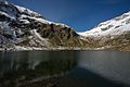
Rantensee versus Rantentörl

Upper course in the rear ditch


In its upper reaches, the Rantenbach is a small alpine torrent . It rises around 2050 m above sea level. A. in a Hochkar south of the Rantentörl ( 2166 m ), on the main ridge of the eastern Schladminger Tauern between Predigtstuhl ( 2543 m above sea level ) and Knarrnspitze ( 2387 m above sea level ). After a short stretch of river it reaches, already at 1878 m above sea level. A. , the Rantensee, and then flows through the (Cracow) Rantental even Rantengraben called, in north-south direction. Smaller tributaries come from the Hinterkarsee and Mitterkarsee on the left side of the valley. The narrow valley floor is determined by alpine pastures and loose larch forest . In this section it is supervised by torrent and avalanche control . At running kilometer seven the Prebergraben (Preberbach , also Rantenbach) joins on the right .
Cracow high valley and Ranten gorge

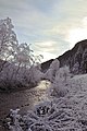
In the Ranten Gorge

After nine kilometers of flowing, the Rantenbach enters the town of Moos ( 1269 m ) in the Krakauer Hochtal (Krakautal) , where the Feisterbach from the Prebersattel joins from the right . In its middle course the stream runs mainly eastwards, Prebertal - Krakautal are part of the Murparalleltal . After the mouth of the Feisterbach stream, the stream passes two diversion power stations and forms the border between Krakauhintermühlen in the north and Krakauschatten in the south on the high valley floor, which is characterized by grassland .
After the village of Brandstatt ( 1160 m ) the consistently wooded Ranten Gorge begins . The brook erodes here into the ice age gravel of the high valley and divides the valley floor between Ober- / Unteretrach and Krakaudorf into two terraces . The brook meanders in the 100-meter-deep gorge and forms impact and sliding slopes . Landslides often occur due to lateral undercutting . In the largely inaccessible gorge, the stream with the Etrachbach takes in a significant left tributary from the interior of the Tauern.
(Rantener) Ranten Valley
At Ranten -Löwenwirt

Estuary at Mursteg in Murau


After the Rantenbach near Seebach ( 961 m ) has left the Krakautal and merged with the Seetaler Bach , its lower course flows through a wider valley, which is again called Rantental , and takes a southeastern direction. He passes the settlements of Ratschfeld , Ranten and Tratten . At flow kilometer 29, at Kulmhammer , the valley narrows again and the stream runs directly on Murtal Straße (B 96) . This narrowing of the valley is geologically unstable on the right bank , here is a large sliding slope (Lärchberg-Galgenwald) .
After another diversion power plant, the Rantenbach reaches the district town of Murau and flows east of the old town at 750 m above sea level. A. in the Mur .
economy

Historically, there are nine iron hammers mentioned near Murau an der Ranten, which were made from the 15th century onwards in relation to the Erzberg . These are the Prixenhammer (urk. 1496–1923), Herrschaftshammer (1667–1876 / 81), Grüblhammer , Brucken - or Zeughammer , wire hammer with nail forge, field hammer , Heiligenstatthammer (until 1805) and the Kulmhammer (urk. 1602–1876 ). Most recently they were all owned by Schwarzenberg ( resident at Murau Castle since 1617 ). Another hammer was with Tratten. The address Am Hammer is a reminder of the city's works , while the Kulmhammer mansion is a listed building.
Today there are several powerful diversion power plants along the stream :
- A predecessor of the Murau power station was built in 1906. The power plant in its current form (net head 28 m, pipeline length 1500 m) was opened by the Murau municipal utilities in 2009 and is designed for a water flow rate of 5000 l / s. The two turbines with a maximum output of 1500 kVA can produce up to million kWh annually and supply around 1000 households with green electricity .
- The Krakautal-Rantenbach power plant in Krakauschatten -Moos consists of two Pelton turbines and was completed in 2016. The system, which is equipped with a damper weir , has a consensus flow rate of 2200 l / s and supplies the Krakow municipality with energy.
- Another power plant with a consensus volume of 3500 l / s is under construction near Seebach until the end of 2017.
nature
The headwaters are located in the Krakau – Schöder nature reserve ( NSa 15 ), the entire upper course in the Lower Tauern European protected area (VS, EU38 / AT2209000 ) and the Schladminger Tauern landscape protection area ( LS11 ).
At the mouth of the river, the Upper and Middle Rivers of the Mur are designated as a European protected area with Puxer Auwald, Puxer Wand and Gulsen (FFH, EU5 / AT2236000).
Web links
Individual evidence
- ↑ a b c d Rantenbach. Wasserbuch Steiermark online (wis.stmk.gv.at), and Digitaler Atlas Steiermark .
- ↑ BMLFUW (ed.) : List of areas of the Austrian river basins: Mur area. In: Contributions to Austria's Hydrography Issue No. 60, Vienna 2011, p. 16.
- ↑ Georg Seidl: Estimation of the hydraulic geopotential of Austrian side feeders. Diploma thesis at the Department of Water, Atmosphere and Environment of the University of Natural Resources and Life Sciences , Vienna 2012, p. 70.
- ↑ Reinhold Lazar & Gerhard Lieb: Landscape Guide Krakow. Austria-Medien-Service, Graz 1996, pp. 185–186. ISBN 3-85333-015-0 .
- ↑ Stefan Hausegger: The internal deformation of large slope movements using the example of the mass movement Lärchberg-Galgenwald (Murau, Styria). Master's thesis, Karl-Franzens-University Graz, March 2006 ( pdf , uni-graz.at).
- ^ Austrian city atlas: Murau. Online at arcanum.hu - comment , paragraph Companies have the mentioned Hammerherren ... (after Adolf Mannich: Murauer Hammerherrenbuch. Schwarzenberg Archive Murau, unpubl.) And growth phase map with legend , No. 82, 84, 85, 86 (accessed September 26, 2019 ).
- ^ Adolph Berger: The Princely House of Schwarzenberg. 1866, p. 323, no. 6-11 (reprinted limited preview in Google book search).
- ↑ The vision was implemented, the power plant to be demonstrated. (No longer available online.) Murtaler Zeitung, July 16, 2009, archived from the original on February 16, 2017 ; accessed on February 15, 2017 . Info: The archive link was inserted automatically and has not yet been checked. Please check the original and archive link according to the instructions and then remove this notice.
- ↑ Excerpt from the water book - KW Krakautal Rantenbach GmbH 14/1961. State of Styria , accessed February 15, 2017 .
- ↑ Extract from the water book - Wasserkraftwerk Rantenbach GmbH 14/1491. State of Styria , accessed February 15, 2017 .