Rappoldkogel
| Rappoldkogel | ||
|---|---|---|
|
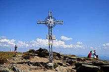
Rappoldkogel from the east |
||
| height | 1928 m above sea level A. | |
| location | Styria , Austria | |
| Mountains | Stubalpe , Lavanttal Alps | |
| Dominance | 3.8 km → Speikkogel | |
| Notch height | 385 m ↓ Hirschegger saddle | |
| Coordinates | 47 ° 5 '3 " N , 14 ° 53' 0" E | |
|
|
||
| rock | Mica slate | |
The Rappoldkogel is 1928 m above sea level. A. high mountain in the Lavanttal Alps in the Austrian state of Styria . It forms the highest point in the Stubalpe and is a popular touring destination all year round.
Location and surroundings
The Rappoldkogel rises between the Salzstiegel and Gaberl passes in the Stubalpe , a section of the Styrian peripheral mountains . The border between the districts of Murtal in the north (municipality of Weißkirchen ) and Voitsberg in the south (municipality of Hirschegg-Pack ) runs along the south and southeast ridge of the mountain , towards the northwest a ridge runs to the Schwarzkogel ( 1817 m ). The mountain is part of the Amering-Stubalpe conservation area . The closest bases are the Salzstiegelhaus ( 1543 m ) and the Alte Almhaus ( 1649 m ), each accessible via public roads.
Geology and geomorphology

The mica schist , which occurs over a large area on the Rappoldkogel, is eponymous for a type of rock that is widespread up to the Gleinalpe . The often folded and coarse-leaved rappold mica schist is contrasted with mica quartzite in many places, for example on the southern summit . The examination of handpieces revealed little mineralogical differences between the two rocks, but the Rappold mica schists seem to have gone green to a greater degree . Legacy are schistose amphibolites and fine and middle grain garnet mica schist at the base of the striking rock formation on the south ridge. On the flat slope against the salt pan, marble with pegmatite contact occurs .
A striking surface feature of the Rappoldkogel are the rock formations, called ovens , which occur from around 1750 m , which contrast with the otherwise gentle mountain landscape. The rock slabs that emerge on the eastern slope are folded and occasionally contain muscovite . Overall, the mountain shows comparatively flat slopes to the north and east, while the south and west sides drop steeply into the valley. Due to the geological situation there are numerous source outlets, including Rafflerbach (inflow to the Teigitsch ) and Kothbach (inflow to the Mur ).
history
On the western slopes of the Rappoldkogel, copper was mined by the St. Lambrecht monastery from 1174 . There are only sparse records of further mining activity on the mountain. Only an entry from 1799 in the digging, courage and confirmation book of the archives of the Leoben district administration grants a certain Joseph Roschitz, owner of the “Freyval Thiergarten zu Graz”, the right to use copper in the “Rapold and Stubalpen” area dig. However, a centuries-old legend of the “Goldbründl” also suggests a former gold deposit .
“Every summer a beautiful white woman comes to a clear fountain on the Rappoldkogel. She spreads a handkerchief under the trickling spring. Then she lays it out on the lawn to dry. You can see a fine glitter in the handkerchief, as if nothing but gold threads shone inside. "
The foreman Johann Eder († 1970), who came from coal mining , carried out research in the region in this regard. After being in a poor box at the Holy Blood Church Voitsberg had discovered a reference to Mountain Gold, he examined in 1949 - having regard to Rappold forecast - spring waters Hirschegger digging until he succeeded the proof of kalloidem gold. With that, the Rappoldkogel was established as a “gold-bearing mountain” for Eder. The miner also recognized that the church deviates from the usual west-east orientation and is precisely aligned with the mountain, which is a good 20 km away. Depressions near the peaks are seen as possible remains of roses or tunnels .
Another legend tells of the Pestwuzel on the Rappoldkogel. It is said to have come up from a deep hole in the mountain from time to time and brought the plague over the country. One morning, on a Handay - according to other accounts of Peter and Paul - the survivors of an epidemic gathered up and dozens of them hiked to the top. People gathered in a circle around the hole, prayed and threw stones and earth into the pit. When the shoal was completely buried, a tree was planted and the buttercup was trapped underground forever.
Ascent
The summit can be reached from two sides via hiking trails. The fastest ascent is from the Salzstiegelhaus on the Hirschegger Sattel ( 1543 m ) in one hour over the south ridge. A striking rocky area in front of the summit requires surefootedness, but can be bypassed on the right in the forest. From the Altes Almhaus ( 1649 m ) the Rappoldkogel can be reached first via the forest road and finally via the southeast ridge - steeply through the forest and over grassy crests - in 1½ hours. In combination, both paths represent a variant of the north-south long-distance hiking trail (marking 505b), the main route of which runs over a forest road on the southern slope of the mountain. Due to the short walking times, the mountain is climbed very often.
Web links
Literature and maps
- Günter and Luise Auferbauer: Graz local mountains. With Mur and Mürz valleys . Bergverlag Rother, Munich 2000, pp. 72-73, ISBN 3-7633-4292-3 .
- Freytag & Berndt Vienna, hiking map 1: 50,000, WK 212, Seetaler Alps - Seckauer Alps - Judenburg - Knittelfeld , ISBN 978-3850846813 .
Individual evidence
- ↑ a b F. Angel & F. Heritsch : A contribution to the petrography and geology of the Central Styrian crystalline mountains of the Stubalpe. In: Yearbook of the Federal Geological Institute LXIX, Bd. 1919, pp. 43–206. PDF
- ↑ Digital Atlas of Styria: Geology & Geotechnics. State of Styria , accessed April 4, 2017 .
- ^ A b Hans Eck: Mining and mineralogy of Hirschegg and the surrounding area. In: Ernst Lasnik (Ed.): 750 years of Hirschegg. Portrait of a special western Styrian place , Hirschegg 1996, pp. 343–348.
- ↑ Walter Kainz: The beautiful woman on the Rappoldalm . In: Weststeirische Sagen , Verlag für Collectors, Graz 1986, p. 40.
- ↑ Ernst Lasnik : Legends and stories from Hirschegg. In: 750 years of Hirschegg. Portrait of a special western Styrian place , Hirschegg 1996, pp. 358–371.
- ↑ Günter and Luise Auferbauer: Grazer local mountains. With Mur and Mürz valleys . Bergverlag Rother, Munich 2000, pp. 72-73, ISBN 3-7633-4292-3 .


