
Rauschberg
| Rauschberg | ||
|---|---|---|
 The Rauschberg |
||
| height | 1671 m | |
| location | Bavaria | |
| Mountains | Chiemgau Alps | |
| Dominance | 4.7 km → Aibleck | |
| Notch height | 706 m ↓ east of the Keitlalm | |
| Coordinates | 47 ° 44 '1 " N , 12 ° 41' 48" E | |
|
||

The Rauschberg is a mountain range with several peaks in the Chiemgau Alps a good five kilometers as the crow flies southeast of the center of Ruhpolding . It is located in Zell Forst, formerly an unincorporated community and now a district of the municipality Ruhpolding.
The Vordere Rauschberg ( 1645 m ) in the west of the Bergstock can be reached either with the Rauschbergbahn, built in 1953, or as an easy mountain hike. It is a popular hiking destination because it offers an excellent view of the entire foothills of the Alps . For example, you can see the Chiemsee , the Hochstaufen , the Unterberg , the Hochfelln , the Zwiesel and the Ristfeuchthorn . You can even make out two of the highest mountains in Austria, the Großglockner and the Großvenediger . The highest point is the Hintere Rauschberg at 1671 m ; other peaks in the eastern part of the mountain range are the Streicher ( 1594 m ) and the Zenokopf ( 1603 m ), which together form the end of the Inzell Kienberg .
Development
Around the summit, the Bavarian State Forests, together with the mountain association, have created an alpine educational trail on which typical high mountain plants can be seen and explained with information boards. In a man-made, hollowed-out tree trunk with an interior height of around 1.60 m at a prominent point on the nature trail, you can see some of the mountain's small animals such as an alpine buck , an adder or a white-backed woodpecker .
On the summit of the Rauschberg there is a launch pad for hang-gliders and paragliders. The mountain station is used for events and exhibitions. Sculptures by Angerer the Younger can be found in the vicinity of the station . When hiking back to Ruhpolding in summer, you can also meet German biathletes , cross-country skiers and Nordic combined athletes who are doing their preparations there.
In winter, the Rauschberg is an area for ski tours : the former family run is a popular choice as a route for the ascent, and when the snow conditions are safe, experienced tourers can ski down the "Roßgasse", one of the steepest runs in Upper Bavaria. Regular operation of groomed slopes ceased at the end of the 1990s and most of the lifts were dismantled.
geology
The Rauschberg mountain range, which belongs to the Northern Limestone Alps ( Chiemgau Alps ), is mainly built up from Wetterstein limestone up to 700 meters thick . This Central Triassic reef limestone was deposited around 230 million years ago in the Tethys on the southern edge of the European continent during the Ladinian ( Langobardian ). It shows clear karstification phenomena , recognizable by sinkholes and lintel shafts.
On the Rauschberg, the strata generally dips slightly to the south and then merges into a broad, flat synclinorium in the direction of Sonntagshorn , which has a subordinate bulge with a corresponding depression north of the Schwarzache in the area of the Sack Trench . The southern slopes of the Rauschberg massif are occupied by overlying Raibler layers .
Structurally geologically, the Rauschberg is located on the front of the Tyrolean Staufen-Höllengebirgs-Nappe , which was slanted upwards or over the Bavarian Lech Valley Nappe in the course of the Alpid orogenesis in a north to northwest direction . The thrust front continues south of Inzell in an east-west direction, but then gradually turns in a south-west direction towards Ruhpolding. At the Taubensee, for example, it crosses the Neokom and Cenomanium of the Lechtal ceiling with alpine red sandstone , Werfener layers , Rauhwacke and shell limestone at the base .
Mining

At the Rauschenberg , as it was then called, lead - zinc mining was carried out since the 16th century . Historically, this is mentioned for the first time in 1559. He mainly concentrated on three hunting areas on the north-eastern edge of the mountain:
- The area of the Ewigganges north below the Streicher - mining activities from 1666 to 1826.
- The area north below the Zenokopf, with Josephsgang and Barbaragang - from 1684.
- The area in the Roßgasse ( Hohe Schrög ) with the Strahleckergang - 1721 to 1746.
In addition, numerous search tunnels were sunk between 1684 and 1739.
The total length of all tunnels and routes in the mountain was around 3500 meters. The amount of ore extracted is estimated at 6,500 cubic meters of solid rock. The ores were smelted in the Inzell district of Schmelz .
Due to the rather irregular mineralization, the mining could only proceed in a raid-like and unplanned manner and experienced great ups and downs until its cessation in 1826. Nevertheless, the Rauschberg was the most important lead-zinc site in Bavaria. Between 1922 and 1926, a last search tunnel was driven beneath the Ewigganges, which only encountered deaf rock.
Mineralization
The lead-zinc deposit on the Rauschberg is an alpine deposit type and belongs to the carbonate-bound sulphidic deposits , whereby ore deposition and enrichment in the reef belt of the Tethys was synsedimentary. As diagenetic primary mineralization of the Wetterstein limestone, coarse lead galena (galena), PbS, and sphalerite , ZnS, which had grown together in a gangue of calcite and dolomite, were mined .
These minerals were seldom accompanied by greenockite , CdS, as yellow coatings and even more rarely by greenish-bluish aurichalcite from the oxidation zone. However, the presence of Descloizit and Ilsemannite ( yellow lead ) is questionable.
Also the secondary formed in the oxidation zone calamine was used - an encrusting mixed crystallization from Smithsonite , Cerussite ( White Lead ) Hydrozinkit and Hemimorphite (also crystalline occurring). So-called black lead , a mixture of galena and cerussite, is found in tectonically disrupted parent rock.
Emergence
On the northern shelf edge of the Tethys, beach reefs grew up in the Ladin, often several hundred kilometers long barrier reefs and atolls . The area decisive for metallogenesis was supratidal and was above the intertidal zone. In the arid , d. H. dry and hot conditions, anoxic sediments could develop in basin depressions , such as digested sludge formed in the absence of oxygen. The hydrogen sulfide released by this process then separated sulfidic ores in the metal solutions enriched by high evaporation. In the presence of chlorine ions, as they typically occur in hypersaline conditions (salt content <5%), lead and zinc in particular were deposited. The original entry of these metals has not been definitively clarified, but is likely to have occurred volcanically exhalatively and to be related to the volcanism that was taking place in the southern Alps .
The summit
The summit cross is designed in the form of a Christian cross , the ends of the crossbar and the upper end are rounded and gold-plated. On its base post is a wooden plaque with the inscription: For the fallen of the community of Ruhpolding, 1914–1918 and 1940–1945 . It was donated by the D'Rauschberger Zell mountain costume association and set up on June 20, 1984.

Summit cross
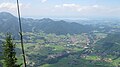
View from the summit cross to Ruhpolding

Adam's hand from Angerer the Younger


literature
- Hans-Otto Angermeier: The geological structure of the Rauschberg area in the Chiemgau Alps . In: Diploma thesis at the Inst. F. general. and applied mineralogy from the University of Munich . 1960.
- J. Knauer: The origin of the lead and zinc ores in the Rauschberg area near Inzell . In: Dep. Geol. State Office at Bayer. Mining Office 30 . 1937.
- Karl August Reiser : History of the lead and calamine mine on the Rauschenberg and Staufen in Upper Bavaria . Wolf, Munich 1895. ( digitized version )
- K. Stier: The zinc-lead ore deposits on the Rauschen mountain near Traunstein . In: metal and ore . Issue 22, 1938.
Web links
- Mountain hikes on the Rauschberg
- "Art on the mountain" of the Rauschbergbahn
- Rauschbergalm . In: Agricultural and cultural heritage database . Society for Agricultural History
Individual evidence
- ↑ Lost ropeways.
- ↑ K. Doben: Explanations of the geological map GK 8242 Inzell . Bavarian Geological State Office, Munich 1973, p. 1-124 .
- ↑ Michael K. Läntzsch: The lead-zinc deposits in the Wetterstein Limestone of the Northern Limestone Alps in the Bad Reichenhall - Inzell area (Bavaria) . In: Bergknappe . Double issue 126/127, 2015, p. 152-171 .
- ↑ R. Pöverlein: The minerals from the dumps at Kienberg near Inzell / Bavaria . In: Lapis . Issue No. 1 vol. 9, 1984, p. 11-14 .