Hunsrückhöhenstrasse

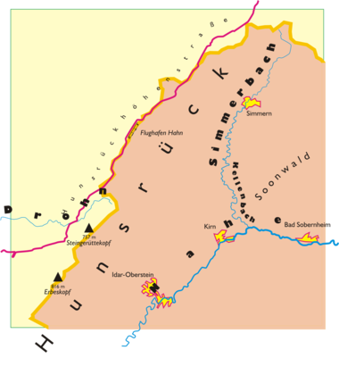
The Hunsrückhöhenstraße ( road with a wide view ) leads across the Hunsrück , 157 kilometers from Saarburg near Trier via Zerf , Kell am See , Reinsfeld , Hermeskeil , Thalfang , Morbach , Hahn , Kappel (Hunsrück) (highest point in the Vorderhunsrück 527 m), Kastellaun and Emmelshausen to Koblenz . Mostly it follows the B 327 and the B 407 .
history
The Hunsrückhöhenstraße was built in the years 1938 and 1939 on the orders of Hermann Göring in a very short time from Koblenz to the Saar by the Todt organization as a strategic military route to the Franco-German border ( Westwall ), including numerous existing routes. Then replenishment stores were set up in the woods on both sides of the road. A field airfield was built in the area of today's training area at Kastellaun . Many Celtic barrows were discovered, but most of them were destroyed, including Bell's chariot grave .
After completion (140 km in just 100 days) the route was first referred to as Hunsrückstraße , then as Reichsstraße 327 or Reichshöhenstraße . The name Hunsrückstraße can still be found today as a street name in the town of Reinsfeld.
The construction of the Hunsrückhöhenstrasse is also discussed in "Part 4: Reichshöhenstrasse (1938)" of the film epic Heimat - A German Chronicle by Edgar Reitz .
description
It partly follows the route of a Roman military road that led from Augusta Treverorum ( Trier ) via Noviomagus ( Neumagen-Dhron ), Belginum ( Stumpfer Turm near Wederath ). There a route branched off to the east, which ran via Dumnissus ( Kirchberg ) and Bingium ( Bingen ) to Mogontiacum ( Mainz ). This street is marked in the Roman road map of the 4th century ( Tabula Peutingeriana ) and mentioned in the poem Mosella by the Roman poet Decimius Magnus Ausonius (368), which is why this street is also called Ausoniusstraße or Ausoniusweg today. Straight on it went on to Bell , from there one branch led via Beltheim , Sevenich , Schöneck towards Koblenz , another north-east over the height to Gammelshausen , Braunshorn towards Boppard .
Landmarks, tourism

- Air exhibition Hermeskeil
- Belginum Archaeological Park near Wederath
- Michaelskirche and market square in Kirchberg (Hunsrück)
- Castle hill and castle ruins Kastellaun
- Hunsrückbahn Boppard to Emmelshausen with tunnel and viaducts
Current
The Hunsrückhöhenstraße between the Raversbeuren exit and the confluence of the B 50 is now interrupted. The federal highway 327 was dismantled in this area by the western extension of the runway at Hahn Airport . The route leads from Koblenz from Kappel in the direction of the B 50, where the new route is also known as the B 327.
Individual evidence
- ↑ Map comparison of the topographic map 1: 200,000 sheets Coblenz / Koblenz from 1925 Archived copy ( Memento of the original from March 5, 2016 in the Internet Archive ) Info: The archive link was inserted automatically and has not yet been checked. Please check the original and archive link according to the instructions and then remove this notice. and 1939 Archived copy ( Memento of the original from March 5, 2016 in the Internet Archive ) Info: The archive link was inserted automatically and has not yet been checked. Please check the original and archive link according to the instructions and then remove this notice. as well as sheet Trier from 1925 Archived copy ( Memento of the original from March 5, 2016 in the Internet Archive ) Info: The archive link was inserted automatically and has not yet been checked. Please check the original and archive link according to the instructions and then remove this notice. and 1940 Archived copy ( memento of the original from January 6, 2014 in the Internet Archive ) Info: The archive link was automatically inserted and not yet checked. Please check the original and archive link according to the instructions and then remove this notice.
- ↑ Josef Heinzelmann, The way to Trigorium… borders, roads and rule between Lower Moselle and Middle Rhine in the early Middle Ages, in: Yearbook for West German State History 21 (1995), pp. 9–132.