
Richford (Vermont)
| Richford | |||
|---|---|---|---|
 Wheeler House listed on the National Register of Historic Places . |
|||
| Location in Vermont | |||
|
|||
| Basic data | |||
| Foundation : | August 21, 1780 | ||
| State : | United States | ||
| State : | Vermont | ||
| County : | Franklin County | ||
| Coordinates : | 44 ° 57 ′ N , 72 ° 36 ′ W | ||
| Time zone : | Eastern ( UTC − 5 / −4 ) | ||
| Residents : | 2,308 (as of 2010) | ||
| Population density : | 20.6 inhabitants per km 2 | ||
| Area : | 112.1 km 2 (approx. 43 mi 2 ) of which 112.0 km 2 (approx. 43 mi 2 ) are land |
||
| Height : | 286 m | ||
| Postal code : | 05476 | ||
| Area code : | +1 802 | ||
| FIPS : | 50-59125 | ||
| GNIS ID : | 1462185 | ||
| Website : | RichfordVT.com | ||

Richford is a town in Franklin County , Vermont , United States with 2308 inhabitants (2010 census)
geography
Geographical location
Richford is located in the northeast of Franklin County, near the Canadian border in the northern foothills of the Green Mountains and is traversed by the Missisquoi River , which changes here from Canada. There are few smaller lakes in the town area, the largest being Guillmettes Pond . The area of the town is hilly, the highest being the 354 m high Hardwood Hill .
Neighboring communities
All distances are given as straight lines between the official coordinates of the places from the 2010 census.
- North: Sutton , Canada, 3.4 mi
- East: Jay , 10.1 km
- South: Montgomery , 1.9 mi
- Southwest: Enosburgh , 17.1 km
- West: Berkshire , 9 miles
City structure
There are three settlement areas in Richford, Village Richford, East Richford and Stevens Mills.
climate
The mean mean temperature in Richford is between -11.7 ° C (11 ° Fahrenheit ) in January and 18.3 ° C (65 ° Fahrenheit) in July. This means that the place is around 9 degrees cooler than the long-term average in the USA. The snowfall between mid-October and mid-May is more than two meters, about twice as high as the average snow depth in the USA. The daily sunshine duration is at the lower end of the range of values in the USA, between September and mid-December it is even significantly lower.
history
The Grant to Richford was proclaimed by Thomas Chittenden and the Vermont Republic on March 13, 1780. Along with five other places in the area to raise money for the Vermont Army. For this purpose, the land was divided into parcels and sold to settlers. The grant was given to Jonathan Wells and others on August 21, 1780. In 1795 the first piece of land was taken over by Joseph Stanhope and Hugh and Marry Miller and their families were the first to settle. The town's constituent assembly took place on March 30, 1799.
The residents earn their living primarily in agriculture and forestry as well as various craft businesses; Big industry is not located in Richford. Since the 1970s, the place has tried to become a tourist recreation center with some success. To this end, various trails have been set up that cover all four seasons of the year and some of them also cross the national border. Whitewater and canoe trips on the Missisquoi River have also been established.
religion
There are four parishes in the city: the Baptists , the Episcopal Church , the Roman Catholic Church and the Methodists .
Population development
| Census Results - Town of Highgate, Vermont | ||||||||||
|---|---|---|---|---|---|---|---|---|---|---|
| year | 1800 | 1810 | 1820 | 1830 | 1840 | 1850 | 1860 | 1870 | 1880 | 1890 |
| Residents | 113 | 440 | 440 | 704 | 914 | 1074 | 1338 | 1481 | 1818 | 2196 |
| year | 1900 | 1910 | 1920 | 1930 | 1940 | 1950 | 1960 | 1970 | 1980 | 1990 |
| Residents | 2421 | 2907 | 2842 | 2544 | 2646 | 2643 | 2316 | 2116 | 2206 | 2178 |
| year | 2000 | 2010 | 2020 | 2030 | 2040 | 2050 | 2060 | 2070 | 2080 | 2090 |
| Residents | 2321 | 2308 | ||||||||
Economy and Infrastructure
traffic

Vermont Route 105 runs along the Missisquoi River from the Canadian border in the northeast towards Enosburgh in the southwest . In the village of Richford, Vermont Route 139 branches off in a northerly direction towards the Canadian border . The next Amtrak station is in St. Albans.
Public facilities
The Northwestern Medical Center in St. Albans is the closest hospital for residents of the Town.
education
Richford belongs to Bakersfield, Berkshire, Enosburg and Montgomery to Franklin Northeast Supervisory Union The Richford Elementary School offers classes from kindergarten to sixth grade. Also the Richford Junior Senior High School .
Larger colleges can be found in Colchester and Winooski ; the closest university location is Burlington .
The AA Brown Library was founded on 1895. The farmer and lumberjack Arvin A. Brown left his property to the population and the town. Initially located on Main Street, the library moved to today's Town Hall in 1915. As the library grew and needed more space, the current building was moved into in 1984.
photos

Old Town, Main Crossing
The old town is listed as an ensemble in the National Register of Historic Places .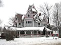
Sheldon Boright House
listed on the National Register of Historic Places .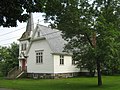
St. Anns Church
listed on the National Register of Historic Places .
Missisquoi River Bridge
listed on the National Register of Historic Places .


Personalities
sons and daughters of the town
- John Blaisdell Corliss (1851–1929), Congressman and attorney.
- E. Henry Powell (1839–1911), American lawyer and politician who was a Vermont State Auditor
literature
- Zadock Thompson: History of Vermont, natural, civil and statistical, in three parts . 3rd volume. Chauncey Goodrich, Burlington 1842, p. 148 f . ( limited preview in Google Book search).
- Abby Maria Hemenway: The Vermont historical Gazetteer, Volume 2 . Burlington 1870, p. 278 ( limited preview in Google Book search).
Web links
- Community website
- Profile of the municipality on the official portal www.Vermont.gov
- Entry at VirtualVermont (English) ( Memento from October 8, 2016 in the Internet Archive )
Individual evidence
- ↑ Richford in the Geographic Names Information System of the United States Geological Survey , accessed 17 March 2012
- ↑ Population data from the 2010 US Census in the American Factfinder
- ↑ Hardwood Hill on Peakery.com , accessed on May 14, 2017
- ↑ Index of / geo. In: census.gov. Retrieved May 18, 2019 .
- ↑ Richford on the City Daty portal , accessed May 14, 2017
- ↑ a b Zadock Thompson: History of Vermont, Natural, Civil, and Statistical, p. 148 , accessed May 14, 2017
- ↑ Town of Richfors , accessed May 14, 2017
- ↑ Population 1800–2010 according to census results
- ^ Franklin Northeast Supervisory Union , accessed May 14, 2017.
- ^ Richford Elementary School , accessed May 14, 2017
- ^ Richford Junior Senior High School , accessed May 14, 2017
- ^ AA Brown Library , accessed May 14, 2017
| City |
 |
|
| towns |
Bakersfield | Berkshire | Enosburgh | Fairfax | Fairfield | Fletcher | Franklin | Georgia | Highgate | Montgomery | Richford | Sheldon | St. Albans (Town) | Swanton |
|
| villages | ||
| CDP |
Richford (CDP) |
|
| More settlements |
East Berkshire | East Fairfield | Georgia Plains | Morse Line | Sheldon Springs | St. Albans Bay |