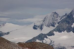
Romaris wall head
| Romaris wall head | ||
|---|---|---|
|
The Glockner wall from the south, on the left the two Romaris wall heads |
||
| height | 3511 m above sea level A. | |
| location | Border between Carinthia and East Tyrol , Austria | |
| Mountains | Austrian Central Alps , Hohe Tauern , Glockner Group , Glocknerkamm | |
| Dominance | 1.4 km → Glocknerwand | |
| Notch height | 85 m ↓ Romaris wall saddle | |
| Coordinates | 47 ° 5 '29 " N , 12 ° 40' 5" E | |
|
|
||
| rock | Prasinite | |
| First ascent | August 29, 1868 by Johann Stüdl , led by Michel Groder and Andreas Kerer | |
| Normal way | from the Stüdlhütte north over the Teischnitzkees , Gramúlsattel and the south ridge | |
The Romariswandkopf is a mountain of the Glockner group consisting of two peaks in the western Tauern main ridge , a mountain range in the Central Alps . It lies exactly on the border between the Austrian federal states of Carinthia and East Tyrol . The main peak is 3508 meters according to the literature, as specified by the Austrian Federal Office of Metrology and Surveying , however, 3511 meters high. The north-west summit, on the other hand, is only 3491 meters high. The two peaks are about 120 meters apart. The mountain emits pronounced ridges to the northwest, east and southwest. The south ridge is known as the Romaris wall because of its size .
The Romariswandköpfe can be easily reached from the Oberwalder Hütte to the northeast via the Pasterzeboden glacier or from the Stüdlhütte to the south via the Teischnitzke and the Fruschnitzkees. The heads were first climbed and crossed on August 29, 1868 by the Prague merchant and alpinist Johann Stüdl and the mountain guides Michel Groder and Andreas Kerer from Kals .
Location and surroundings
The Romariswandkopf belongs to the Glocknerkamm and is completely surrounded by glaciers. In the north extends the snow angle that belongs to the nutrient area of the Pasterze , the largest glacier in the Eastern Alps . To the south of the east ridge is the Fruschnitzkees , which extends to the summit of the Kopf, and to the west of the Romariswand, on the south ridge, is the Laperwitzkees .
Adjacent mountains are in the course of the northwest ridge , separated by the Schneewinkelscharte located at 3412 meters above sea level , the 3476 meter high Schneewinkelkopf and the Eiskögele with a height of 3426 meters. Along the firn-covered Glocknerkamm, to the southeast, separated by the Romariswandsattel at an altitude of 3426 meters , lie the Teufelskamp (3511 m), the Glocknerwand with its seven towers and, beyond the Lower Glocknerscharte (3596 m), finally the Grossglockner .
To the west the Romariswandkopf falls down into the Dorfer Tal , the northern extension of the Kalser Tal . The nearest significant settlements are the East Tyrolean Ködnitz near Kals am Großglockner, a good 10 kilometers south as the crow flies , and Kaprun in the Pinzgau region of Salzburg, about 20 km to the north .
Bases and tours
The route of the alpinists in 1868 led from the existing Stüdlhütte at 2,802 meters, the construction of which Johann Stüdl had financed, in a northerly direction over the Teischnitzkees up to the Gramúlsattel (3219 m) and then on over the firn-covered southern ridge of the Romariswandkopf up to the main - and on to the northwest summit. The planned descent down to the Pasterze had to be canceled because the terrain was too steep and the fog was rising. It was not until 1876 that the Prague alpinist Karl Kögler with his guides Josef Kerer and Peter Huter made the transition from the Stüdlhütte to the Pasterze at another point.
Today's normal route follows the first climbers, but is also possible from the Oberwalderhütte , which is 2972 m higher than the Stüdlhütte. Since the Romariswandkopf can only be reached as a serious alpine tour , appropriate equipment and glacier experience are essential. According to literature, the walking time from the Stüdlhütte is about three hours. Most routes are also suitable for ski mountaineers. Further climbs lead over the north-west ridge ( climbing difficulty UIAA II ), through the north face (ice inclination up to 50 °), through the north-east channel (ice 55 °), as well as through the south- west channel (combined ice / rock, 40 ° / UIAA III, 300 meters in altitude) ).
Literature and map
- Willi End : Alpine Club Guide Glockner Group , Bergverlag Rother , Munich 2003, ISBN 3-7633-1266-8
- Eduard Richter : The development of the Eastern Alps, III. Volume published by the German and Austrian Alpine Club, Berlin 1894
- Alpine Club map 1: 25,000, sheet 40, Glockner group
Individual evidence
- ^ Journal of the German and Austrian Alpine Association , Volume II, Munich 1871, p. 357
- ^ Journal of the German and Austrian Alpine Club, Volume VIII, Munich 1877, p. 246 f.
- ↑ Willi End: Alpine Club Guide Glockner Group , Munich 2003, p. 320 ff., Margin no. 1137 ff.


