Samara (Volga)
|
Samara Самара |
||
|
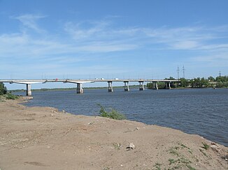
Bridge over the Samara in Samara not far from the estuary |
||
| Data | ||
| Water code | RU : 11010000912112100006161 | |
| location | Orenburg , Samara Oblast ( Russia ) | |
| River system | Volga | |
| Drain over | Volga → Caspian Sea | |
| source | about 50 km northwest of Orenburg 52 ° 3 ′ 25 ″ N , 54 ° 34 ′ 0 ″ E |
|
| muzzle | at Samara in the Volga Coordinates: 53 ° 10 ′ 13 ″ N , 50 ° 4 ′ 10 ″ E 53 ° 10 ′ 13 ″ N , 50 ° 4 ′ 10 ″ E
|
|
| length | 594 km | |
| Catchment area | 46,500 km² | |
| Drain on level Elschanka |
NNQ (January 1938) MQ HHQ (April 1957) |
4.07 m³ / s 45.6 m³ / s 840 m³ / s |
| Left tributaries | Soroka , Pogromka , Busuluk , Domaschka , Tawolschanka , Sesschaja | |
| Right tributaries | Kuwai , Nadeschdinka , Krasnaja , Large Uranium , Small Uranium , Tok , Borowka , Large Kinel | |
| Big cities | Samara | |
| Medium-sized cities | Sorochinsk , Buzuluk , Kinel | |
| Communities | Novosergijewka , Koltubanowski | |
| Navigable | 41 km to Alexejewka | |
|
The Samara seen from space. The Volga on the left, the Ural River on the lower right |
||
The Samara ( Russian Самара ) is a left, 594 km long tributary of the Volga in the southeast of the European part of Russia .
course
The Samara rises southwest of the Ural Mountains northwest of Orenburg in the oblast of the same name , in the Obschtschi Syrt ridge , which forms the watershed to the Urals here. It initially flows south, but after a few kilometers it turns mainly in a westerly direction.
The Kuwai flows north of the Novosergijewka settlement and the Samara turns to the northwest. Shortly before Sorochinsk flows into the Great Uranium . The river continues to flow through the agriculturally used steppe landscape .
Shortly before reaching Buzuluk , the Samara picks up the Tok and the Buzuluk . A few kilometers after the city flows into the Domaschka . At Koltubanowski , shortly after the confluence of the Borowka , the river reaches the border with Samara Oblast .
The Samara now flows in predominantly western directions through the eastern Samara Oblast. It turns northwest of Neftegorsk to the northwest, before flowing in a wide curve to the southwest after the confluence of the Great Kinel to Samara, where it flows into the Volga, which is dammed up to form the Saratov reservoir .
In the ice-free period from mid-April to November, the Samara is navigable for 41 km.
Web links
Individual evidence
- ↑ a b Article Samara in the Great Soviet Encyclopedia (BSE) , 3rd edition 1969–1978 (Russian)
- ↑ a b Samara in the State Water Register of the Russian Federation (Russian)
- ↑ UNESCO - Samara at Elshanka ( Memento of the original from November 25, 2009 in the Internet Archive ) Info: The archive link was inserted automatically and has not yet been checked. Please check the original and archive link according to the instructions and then remove this notice.
- ↑ Samara ( page no longer available , search in web archives ) Info: The link was automatically marked as defective. Please check the link according to the instructions and then remove this notice. in the geographical dictionary of Yandex (russ.)

