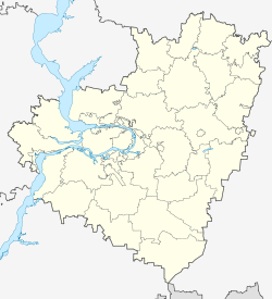
Kinel
| city
Kinel
Кинель
|
||||||||||||||||||||||||||||||||||||||||||
|
||||||||||||||||||||||||||||||||||||||||||
|
||||||||||||||||||||||||||||||||||||||||||
| List of cities in Russia | ||||||||||||||||||||||||||||||||||||||||||
Kinel ( Russian Кинель ) is a city in Samara Oblast ( Russia ) with 34,491 inhabitants (as of October 14, 2010).
geography
The city is located about 40 km east of the Oblast capital Samara at the confluence of the Great Kinel (Bolshoi Kinel) in the Samara , a left tributary of the Volga .
Kinel is directly subordinate to the Oblast administratively, forms its own urban district and is at the same time the administrative center of a Rajon named after him , whereby the city itself does not belong to the Rajon. The urban district also includes the urban-type settlements of Alexejewka (10,411 inhabitants) and Ust-Kinelski (9,988 inhabitants), so that the total population of the urban district is 54,890 (2010 census).
The city is located on the southern branch of the Trans-Siberian Railway Moscow –Samara– Chelyabinsk - Omsk (route km 1139 from Moscow), from which the line to Orenburg - Tashkent branches off. The eastern end of the freight bypass around Samara, which was opened in 1970, is also in Kinel.
history
A first village was founded near today's city in 1837. In 1877 the Samara – Orenburg railway line was passed here; a station settlement was built, named after the river that flows into the Samara not far. In 1892 Kinel was chosen as the starting point for a line initially to Slatoust ( Samara-Slatouster Railway ), which was extended a little later to Chelyabinsk and formed the basis for the original route of the Trans-Siberian Railway.
Station settlement and surrounding villages gradually merged; on January 30, 1930 Kinel received urban-type settlement status and on March 16, 1944 town charter .
Population development
| year | Residents |
|---|---|
| 1897 | 1,700 |
| 1939 | 17,034 |
| 1959 | 32,447 |
| 1970 | 39,373 |
| 1979 | 42,051 |
| 1989 | 33,412 |
| 2002 | 34,385 |
| 2010 | 34,491 |
Note: Census data (1897 rounded)
Culture, education and sights
The Samara State Agricultural Academy (university and research institute), founded in 1903, is located in the Ust-Kinelski settlement belonging to the city .
economy
Kinel is a major rail hub (depot, workshops, etc.). There are also companies in the textile, furniture, building materials and food industries. Kinel is the center of an agricultural area.
Individual evidence
- ↑ a b Itogi Vserossijskoj perepisi naselenija 2010 goda. Tom 1. Čislennostʹ i razmeščenie naselenija (Results of the All-Russian Census 2010. Volume 1. Number and distribution of the population). Tables 5 , pp. 12-209; 11 , pp. 312–979 (download from the website of the Federal Service for State Statistics of the Russian Federation)
Web links
- City administration website (Russian)
- Kinel on mojgorod.ru (Russian)


