
Novosemeikino
| Urban-type settlement
Novosemeikino
Новосемейкино
|
||||||||||||||||||||||||||||||
|
||||||||||||||||||||||||||||||
|
||||||||||||||||||||||||||||||
.svg)

Novosemeikino ( Russian Новосеме́йкино ) is an urban-type settlement in Samara Oblast ( Russia ) with 9750 inhabitants (as of October 14, 2010).
geography
The settlement is located about 25 km northeast of the town center of the Samara Oblast Administrative Center , not far from the boundary of the urban district in the western part of the Sokolowy Gory ridge. The place is about 6 km from the left bank of the Sok , a few kilometers above its confluence from the left into the Volga .
Novosemeikino belongs to the Krasnoyarsky Raion and is located about 6 km south of its administrative center Krasny Yar . It is the seat of the municipality (gorodskoje posselenije) Novosemeikino, which also includes the two villages Starosemeikino (7 km northwest) and Wodino (4.5 km east) as well as the Dubki settlement (7 km east-southeast).
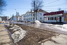
Older residential development (1950s at the latest) on Zhiguljowskaya Street
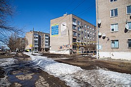
Apartment buildings from the 1970s on Sovetskaya Street

Kosmas and Damian Church (built 2001)


history
A village called Semeikino was first mentioned in 1750, at the beginning of the 19th century as Novo-Semeikino ("New Semeikino"), located on the road and post route from Samara to Krasny Yar and further north and more important than neighboring Staro -Semeikino ("Alt-Semeikino") on the Sok.
The settlement developed in its current form from the 1930s, when the development of a sulfur deposit began a little to the east . During the Second World War , one of the most powerful radio stations at the time was opened on the north-western outskirts and was used for military and civil purposes (" Popow Radio Center", closed in 2005; the four 150 and four 200 meter high transmission masts were demolished in 2010).
In 1959 Novosemeikino has the status of an urban-type settlement.
Population development
| year | Residents |
|---|---|
| 1959 | 8246 |
| 1970 | 9234 |
| 1979 | 9271 |
| 1989 | 9802 |
| 2002 | 9721 |
| 2010 | 9750 |
Note: census data
traffic
A few kilometers north of the settlement there is a motorway junction at which the M5 Ural federal trunk road, coming from the northwest from Moscow via Tolyatti , turns northeast towards Ufa - Chelyabinsk . To the west of Novosemeikino leads from the motorway junction to the northern approach to Samara (regional road 36K-887, Moskowskoje schosse ), to the north-east the extensive bypass of Samara, marked as regional road 36A-144.
In Nowosemeikino is the train station Wodinskaja (named after the eastern village Wodino) at kilometer 170 of 1,962 continuously opened railway Syzran - Zhigulyovsk - Samara. The section via Vodinskaya was built between 1938 and 1940 as part of the line from Samara (then Kuibyshev, Besymyanka station ) to Krasnaya Glinka .
Web links
- Settlement web portal (Russian)
- Novosemeikino on the official website of the Raion Government (Russian)
Individual evidence
- ↑ a b Itogi Vserossijskoj perepisi naselenija 2010 goda. Tom 1. Čislennostʹ i razmeščenie naselenija (Results of the All-Russian Census 2010. Volume 1. Number and distribution of the population). Tables 5 , pp. 12-209; 11 , pp. 312–979 (download from the website of the Federal Service for State Statistics of the Russian Federation)
| Cities |
Kinel S / R | Neftegorsk R | Novokuibyshevsk S | Oktyabrsk S | Otradny S | Pochwistnewo S / R | Samara S / R | Zhigulyovsk S | Sysran S / R | Tolyatti S / R | Chapayevsk S |
|
| Urban-type settlements |
Alexeyevka | Balascheika | Besentchuk R | Meshduretchensk | Mirny | Novosemeikino | Ossinki | Petra Dubrawa | Roschtschinsky | Smyshlyaevka | Stroikeramika | Suchodol | Ust-Kinelski | Wolschski |
|
| Other Rajon centers |
Alexeyevka | Bogatoje | Bolshaya Glushitsa | Bolshaya Chernigovka | Borskoye | Khvorostyanka | Issakly | Jelchowka | Kamyshla | Kinel-Cherkassy | Kljawlino | Koschki | Krasnoarmeiskoye | Krasny Jar | Pestrawka | Privolschye | Schentala | Schigony | Sergievsk | Chelno-Verzhiny |