Ural (river)
|
Urals - Schajyq Урал, Жайық |
||
|
Map of the Urals |
||
| Data | ||
| Water code | RU : 12010000112112200001016 | |
| location | Kazakhstan , Russia | |
| River system | Ural | |
| source | in the Southern Urals 54 ° 42 ′ 10 ″ N , 59 ° 25 ′ 5 ″ E |
|
| muzzle | in the Caspian Sea Coordinates: 46 ° 53 ′ 0 ″ N , 51 ° 37 ′ 0 ″ E 46 ° 53 ′ 0 ″ N , 51 ° 37 ′ 0 ″ E |
|
| Mouth height |
28 m below sea level
|
|
| length | 2428 km | |
| Catchment area | 244,280 km² (according to other sources 231,000 km²) | |
| Drain |
MQ |
297 m³ / s |
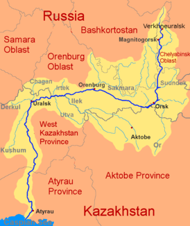
| Left tributaries | Or , Ilek , Utwa , Bolshoi Kumak , Suunduk , Gumbeika , Dongus | |
| Right tributaries | Sakmara , Tschagan , Tanalyk , Irtek , Kuschum , Bolshoi Kisil , Guberlja , Chudolas | |
| Reservoirs flowed through | Iriklinski reservoir | |
| Big cities | Magnitogorsk , Orsk , Orenburg , Oral , Atyrau | |
|
Catchment area of the Urals with tributaries |
||
|
Bridge over the upper reaches of the Urals on the Belorezk - Uchaly road in Bashkortostan / Russia . The stele with the word Europa in the background indicates the inner Eurasian border, which the river marks. |
||
The 2,428 km long Ural ( Russian Урал / Ural ; Kazakh Жайық / Schajyq ; formerly called Russian Яик / Jaik ) is a Eurasian river in Russia and Kazakhstan . According to the most common definition of the inner Eurasian border , it is the border river between Europe (western bank) and Asia (eastern bank).
River course
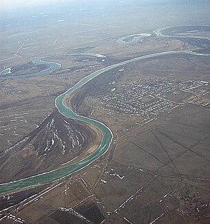
The Urals rises in Russia in the northeastern foothills of the Awaljak ridge (Russian Аваляк ) in the southern Urals (Russian Южный Урал ), in a south-west oriented valley basin formed with the perpendicular alabija ridge (Russian Алабия ). The source lies in 790 m height, 16 km north of the town Burangulowo (Russian Бурангулово ), Rajon uchaly (Russian Учалинский район ), Republic of Bashkortostan (Russian Башкортостан ), about 150 km north of Magnitogorsk , where the Ural between two in North South-facing mountain ranges in a southerly direction and through the Iriklinski reservoir to Orsk . There it bends (at the so-called Ural knee ) at an approx. 90 ° angle to the west and only reaches Orenburg . After crossing the border with Kazakhstan, he reaches Oral . The now navigable river turns south to flow through the Kazakh lowland steppe and the north of the Caspian Depression . About 500 km (as the crow flies ) further south of Oral it flows into the Caspian Sea in several arms in western Kazakhstan near Atyrau - forming a swampy and reed-rich estuary delta .
River length
There seems to be some disagreement about the length of the Urals. Usually the length is given as 2428 km, but 2534 km or much less often 2573 km can also be found.
Inner Eurasian border
The Ural River forms - together with the mountains of the same name - the defined border between Europe and Asia and thus divides Eurasia into two unequal continents .
Catchment area
The catchment area of the Urals covers 244,280 km².
Tributaries
The largest tributary of the Urals is the Sakmara , which flows into it on the right-hand side near Orenburg from the north.
places
Name of the river
The Ural river was called Jaik (Яик) in Russian until the beginning of the reign of Catherine II in the 18th century . After the suppression of the Pugachev uprising , during which extensive fighting had taken place in the river region, the Jaik was renamed Ural ( Ural ) on Katharina's instructions , probably also to erase the memory of this uprising. The current Kazakh name of the river, Schajyq (Жайық), is the direct phonetic development of the old name Jaik . The old Turkish name of the Urals Yayıq has been handed down to Menander in the form of Δαιχ.


