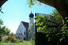
Grafentraubach Castle
The Count Traubach Castle lies on the banks of the little Laber in the town district Laberweinting in the Lower Bavarian district of Straubing-Bogen of Bavaria (Graf Traubach 201).
history
A separation of Holztraubach ( belonging to Mallersdorf-Pfaffenberg ) and Grafentraubach (now part of Laberweinting ) did not take place until the 14th century. Until then, both localities and Hofmarken are meant by the name Traubach . Between 765 and 791, under the witness Bishop Simpert, the priest Horscolf bequeathed his property (a farm, a house, five servants, two servants, three maidservants, also sheep, cattle, fields, meadows and forests) including the church in Traubach to the monastery of St. Emmeram . Between 875 and 885 the monastery exchanged goods in Traubach, whereby the place came into secular possession. In 1165, an Adalbert Graf von Kirchberg zu Eitting and Traubach is mentioned in a document from the Mallersdorf monastery . Between March 31, 1206 and December 10, 1223 this monastery acquired a vineyard from Adalbertus de Druchpach . Between 1214 and 1231, a Heinricus de drupach appears as a witness to a ducal confirmation of the freedoms of the Mallersdorf monastery . In 1220 Heinrich von Zaitzkofen transferred the court away to the Paring monastery , whereupon the provost and convent transferred the salmann's rights to the knight Haeinricus von Drohpach . In 1339 Dietrich der Ammann von Traubach appears. In 1349, Rüdiger der Greul von Habelsbach gave a subordinate Alhaid von Draupach to the Mallesdorf monastery . In 1389 a Rieder appears as a caretaker for Traubach. Probably the Traubecks held the Hofmark between 1176 and 1450. At the beginning of the 13th century, the Regensburg bishop enfeoffed the Traubecks with Traubach.
Before 1321, Grafentraubach became the property of Lavan and was sold by them in 1360. Since Holztraubach is still owned by Friderich Traubeck in 1356, the separation seems to have taken place at that time. In 1361 the knight Heinrich von Steim (n) sold the Grafentraubach fortress to Peter Chammerauer zu Heilstein. On October 16, 1367, Albrecht the provost of Grafentraubach appears. In 1373 there is a Jordan bailiff in town. December 15, 1391, Mr. Bernhard der Traubeck seals a certificate in which Ulrich der Huber, sitting in Grafentraubach, appears. This is seen as an indication that the Traubecks then ruled both places. On July 31, 1396, Friedrich Smieher , nurse and judge in Grafentraubach , gave a court letter to his master Wilhelm Fraunberger , who was in Traubach in the Hofmark. This differentiates between gray drawpach and drawpach . In 1437 Stephan Pullacher was a carer in the village. Between 1440 and 1449 Grafentraubach belonged to the Fraunbergers, who had exercised jurisdiction here since 1396. However, Grafentraubach may already have come to Rain through Anastasia, daughter of Degenhard Hofer zu Sünching, to her husband Haimeran I. In her second marriage she married Heinrich Nothphia zu Wernberg, which means that this family also appears as the owner of Grafentraubach. In 1443 Grafentraubach is called Nidertraubach in contrast to Obertraubach , the earlier Holztraubach. In 1453, Martin Kleindienst was the keeper of Grafentraubach. In 1464 Hans Fraunberger reappeared as owner of the Hofmark Nyderndraupach . In 1471 Eckhart Ziehrer was a carer in Grafentraubach. The Rainer and their descendants are owned by Grafentraubach between 1470 and 1578. Peter and Christoph Rainer auf Grafentraubach (1470), Peter Rainer (1494), Haimeran and Christoph die Rhainer zu Graßlfing and Grafentraubach (1510), Christoph Rhainer zu Rhain (1514), Haimeran and Christoph zu Rain (1532–1542) are named, Hans Rhain zu Pernberg, Grafentraubach, Graßlfing and Mausham (1549), the lords of Rain on Grafentraubach (1558) and the Rhainer (1560–1578). In 1573 Ursula, the underage daughter of the late Hans Joachim von Rain, married Paul von Leiblfing, which marked the beginning of the period of Leiblfinger rule in Grafentraubach. In the land table from 1597 these are listed as owners, they remain Hofmark owners until 1646. 1614 Max Hueber Richter is in town. In 1646 the Hofmark passed from the Leiblfinger creditors to Albrecht von und zu Haimhausen, electoral chamber councilor. In 1659, Grafentraubach went to her husband Philipp Jakob von Ginsheim (Ginsheimb) as a dowry from Anna Maria von Haimhausen.
On March 10, 1749, Imperial Count Joseph Franz Maria von Seinsheim zu Sünching acquires the Grafentraubach, Graßlfing and Hofkirchen court brands. On April 19, 1762, for his services, he received the Sünching estate with Grafentraubach, Graßlfing and Hofkirchen combined into a rulership with the Ius gladii . Even after secularization , the Seinsheims stay on Grafentraubbach. The property later became the property of Baron Hoenning O'Carrol and is now privately owned.

Grafentraubach Castle then and now
The current castle dates from the time of the Rainer in 1507. The moated castle shows on the engraving by Michael Wening little changed compared to today. The higher building, which can still be seen with a tin staircase, seems to have been lost, as well as some low farm buildings in front of the castle.
Today the castle consists of two two-storey gabled buildings, the southern one being slightly higher than the northern one. On the courtyard side, roughly between the gables, an onion dome is built on what is presumably an older substructure. According to dendrochronological studies, an elongated barn in block construction dates from the years 1688/90. The core of the complex is medieval, the alterations and extensions are from the 16th century and the first third of the 18th century. The castle is located on approximately 0.5 hectares of land and is surrounded by an intact moat. Parts of the former fortification with wall and moat are still preserved.
literature
- Günther Pölsterl: Mallersdorf. The Kirchberg regional court, the Eggmühl and Abbach nursing courts. (= Historical Atlas of Bavaria, part of Altbayern booklet 53), pp. 249-252. Commission for Bavarian History, Verlag Michael Lassleben, Munich 1979, ISBN 3-7696-9923-8 .
Individual evidence
Web links
Coordinates: 48 ° 47 ′ 28.9 ″ N , 12 ° 17 ′ 1.7 ″ E


