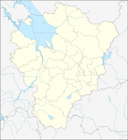
Semibratowo
| Urban-type settlement
Semibratovo
Семибратово
|
||||||||||||||||||||||||||||||||||||
|
||||||||||||||||||||||||||||||||||||
|
||||||||||||||||||||||||||||||||||||
Semibratowo ( Russian Семибра́тово ) is an urban-type settlement in the Yaroslavl Oblast in Russia with 7096 inhabitants (as of October 14, 2010).
geography
The place is a good 40 km as the crow flies south-southwest of the city center of the Yaroslavl Oblast Administrative Center on the left bank of the Ustye , the left source of the Volga tributary, the Kotorosl .
Semibratowo belongs to the Rostovsky Rajons and is located about 15 km north-northeast of the Rostov administrative center . It is the seat of the rural community (selskoje posselenije) Semibratowo, which also includes 78 villages, five of which have more than 500 inhabitants (as of 2010): Belogostizy, Novo-Nikolskoje, Ugoditschi (8, 4 and 16 km south), and Wachrushevo (3 km east) and Vasilkowo (13 km southeast). 6 further villages have at least 100 inhabitants, 23 villages have at least 10 inhabitants, 27 have less than 10 inhabitants and 17 have no permanent residents (all as of 2010).
history
The place has been known as a village since the 15th century. The place name is derived from the Russian sem bratjew for "seven brothers", but the exact background of this name is unclear. In 1693 a post office was built there on the connection between Moscow and Arkhangelsk .
After the railway line Moscow - Yaroslavl - Arkhangelsk had passed by in 1870, the first industrial plants were set up, initially for processing agricultural products, and in 1930 a factory for insulation materials , which was reconstructed in 1949 and from 1959 also produced chipboard . In 1950 a gas cleaning plant was added.
On June 11, 1948, Semibratowo received urban-type settlement status.
Population development
| year | Residents |
|---|---|
| 1959 | 2884 |
| 1970 | 5680 |
| 1979 | 7505 |
| 1989 | 8485 |
| 2002 | 7672 |
| 2010 | 7096 |
Note: census data
traffic
Semibratowo has a train station at kilometer 238 of the trunk line of the Trans-Siberian Railway . There, a route opened in 1927 branches off to the small town of Gavrilow-Jam , about 20 km to the east , which has only been used for freight traffic since 2003.
The M8 Cholmogory federal highway runs through the settlement from Moscow to Arkhangelsk.
Web links
Individual evidence
- ↑ a b Itogi Vserossijskoj perepisi naselenija 2010 goda. Tom 1. Čislennostʹ i razmeščenie naselenija (Results of the All-Russian Census 2010. Volume 1. Number and distribution of the population). Tables 5 , pp. 12-209; 11 , pp. 312–979 (download from the website of the Federal Service for State Statistics of the Russian Federation)


