
Borisoglebsky (Yaroslavl)
| Urban-type settlement
borisoglebsky
Борисоглебский
|
||||||||||||||||||||||||||||||||
|
||||||||||||||||||||||||||||||||
|
||||||||||||||||||||||||||||||||
.svg)

Borissoglebski ( Russian Борисогле́бский ) is an urban-type settlement in the Yaroslavl Oblast in Russia with 5646 inhabitants (as of October 14, 2010).
geography
The place is about 60 km as the crow flies southwest of the Yaroslavl Oblast Administrative Center on the left Kotorosl source river Ustje . Because of the old Russian Boris and Gleb monastery located there, Borissoglebski is considered part of the "Golden Ring" .
Borisoglebsky is the administrative center of the Rajons borisoglebsky and seat of the rural community Borissoglebskoje selskoje posselenije, which includes in addition to the settlement of 40 villages and rural settlements.

Boris and Gleb Monastery 1911 (early color photo by Prokudin-Gorski )

Boris and Gleb Monastery today (2012)

Bell tower (Swonnitsa) from 1690
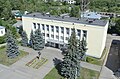
Administration building in Borissoglebski


history
The place goes back to the Boris and Gleb monastery, which was founded there near the important city of Rostov in 1363 with the blessing of Sergius of Radonezh . The settlements that developed around the monastery were summarized as Borissoglebskije slobody (in the plural).
After secularization in the 18th century, the land of the monastery temporarily belonged to Grigory Orlov and the Panin family. Until the 19th century Borissoglebskije slobody developed into a regionally important trading center with an annual big fair around the Orthodox Boris and Gleb Memorial Day (July 24th).
On June 10, 1929 the place became the administrative seat of a newly created Rajons. In 1962 it received the status of an urban-type settlement under its current name.
Population development
| year | Residents |
|---|---|
| 1939 | 3072 |
| 1959 | 3665 |
| 1970 | 4727 |
| 1979 | 5938 |
| 1989 | 6327 |
| 2002 | 5957 |
| 2010 | 5646 |
Note: census data
traffic
The regional road 78K-0003 runs through the settlement, branches off the federal highway M8 Cholmogory Moscow - Arkhangelsk about 15 km south-east near Rostov and continues to the north-west neighboring, about 60 km away Rajon center Uglich .
Rostov is also the closest train station to the main Trans-Siberian Railway .
Web links
Individual evidence
- ↑ a b Itogi Vserossijskoj perepisi naselenija 2010 goda. Tom 1. Čislennostʹ i razmeščenie naselenija (Results of the All-Russian Census 2010. Volume 1. Number and distribution of the population). Tables 5 , pp. 12-209; 11 , pp. 312–979 (download from the website of the Federal Service for State Statistics of the Russian Federation)
| Cities |
Danilov R | Gavrilov-Jam R | Yaroslavl S / R | Ljubim R | Myshkin R | Pereslavl-Zalessky S / R | Poschechonje R | Rostov R | Rybinsk R | Tutayev R | Uglich S / R |
|
| Urban-type settlements |
Borissoglebski R | Burmakino | Konstantinovsky | Ischnja | Krasny Profintern | Lesnaya Polyana | Nekrasovskoye R | Petrovskoye | Porechye-Rybnoye | Pretschistoje R | Semibratowo |
|
| Other Rajon centers |