
Bolshoye Selo (Yaroslavl)
| Village
Bolshoye Selo
Большое Село
|
||||||||||||||||||||||||||||||||||
|
||||||||||||||||||||||||||||||||||
|
||||||||||||||||||||||||||||||||||
.svg)

Bolschoje Selo ( Russian Большо́е Село́ ) is a village (selo) in the Yaroslavl Oblast in Russia with 3522 inhabitants (as of October 14, 2010).
geography
The place is about 60 km as the crow flies west-northwest of the Yaroslavl Oblast Administrative Center on both sides of the right Volga tributary Juchot , a little below the confluence of the left tributary Moloksha .
Bolschoje Selo is the administrative center of Bolzhezelsky Rajons and the seat of the rural municipality of Bolshezelskoe selskoe posselenije. The municipality includes 184 other villages, of which only ten have more than 100 inhabitants: Baikowo (7 km southeast), Dunilowo (4 km north, the largest with 560 inhabitants), Gari (13 km north-west), Igrishchi (2 km south-east) , Ivanzewo (14 km southwest), Miglino (12 km east), Novoje (10 km west), Shamnino (north-west adjoining), Selzo (north-east adjoining) and Vysokovo (13 km south); another 30 places have at least 10 inhabitants, 92 have less than 10 inhabitants and 52 have no permanent residents (as of 2010).
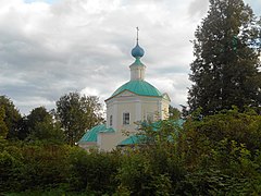
Paraskewa Pyatnitsa Church from 1714

Ruins of the Church of Constantine and Helena (1712) with bell tower (1784)

Wooden house with carvings, originally owned by the merchant Bagrow, today a children's library and editorial office for the Rajon newspaper

Local government

The dammed Juchot river in Bolshoye Selo


history
The village was first mentioned in a document under its current name (literally "Big Village") in 1629, but is probably a few centuries older. It belonged to the principality of Yaroslavl , in the period from its disintegration until the early 15th century to the subdivision of Novlenskoye and finally to 1510 to the principality of Yukhot (or Yukhotskoye, like today's Myshkin at the mouth of the eponymous river in the Volga), which already the Grand Duchy of Moscow was subject to tribute. From 1526 to 1622 the entire area was controlled by the Russian- Lithuanian noble family Mstislavski. In 1706 it came into the possession of Count Boris Sheremetev under Peter the Great and subsequently belonged to the Sheremetev family until the October Revolution of 1917.
After the formation of the governorship of Yaroslavl in 1777 and the governorate of Yaroslavl in 1796, the village came under its Ujesd Uglich , but only gained greater economic importance from the 1820s. In 1861 it became the seat of a Volost , created by dividing the former Yukhotskaya Volost.
After several administrative changes in the early Soviet period, Bolshoye Selo became the seat of a Rajon named after him on January 25, 1935. This was in the meantime dissolved from 1963 to 1965. In 1971 Bolshoye Selo received urban-type settlement status , but lost it again in 1992.
Population development
| year | Residents |
|---|---|
| 1897 | 485 |
| 1939 | 1457 |
| 1959 | 1762 |
| 1970 | 1892 |
| 1979 | 3037 |
| 1989 | 3996 |
| 2002 | 3721 |
| 2010 | 3522 |
Note: census data
traffic
Bolshoye Selo is located on the 78K-0002 regional road from Yaroslavl to Uglich. The 78K-0026 branches off in a north-easterly direction, which after a good 30 km reaches 78K-0001, which follows the right bank of the Volga from Rybinsk and Yaroslavl, about halfway between Rybinsk and Tutajew . To the south, the 78K-0034 initially follows the Moloksha up to the border of the Rajon, then as 78K-0035 to the neighboring Borissoglebski Rajon center, a good 50 km from Bolshoye Selo .
The nearest train station, Lom, on the Yaroslavl - Rybinsk - Bologoje route (km 332, counting from Moscow via Yaroslavl) is located at 78K-0026 about 20 km northeast of the village .
Web links
Individual evidence
- ↑ a b Itogi Vserossijskoj perepisi naselenija 2010 goda. Tom 1. Čislennostʹ i razmeščenie naselenija (Results of the All-Russian Census 2010. Volume 1. Number and distribution of the population). Tables 5 , pp. 12-209; 11 , pp. 312–979 (download from the website of the Federal Service for State Statistics of the Russian Federation)
| Cities |
Danilov R | Gavrilov-Jam R | Yaroslavl S / R | Ljubim R | Myshkin R | Pereslavl-Zalessky S / R | Poschechonje R | Rostov R | Rybinsk R | Tutayev R | Uglich S / R |
|
| Urban-type settlements |
Borissoglebski R | Burmakino | Konstantinovsky | Ischnja | Krasny Profintern | Lesnaya Polyana | Nekrasovskoye R | Petrovskoye | Porechye-Rybnoye | Pretschistoje R | Semibratowo |
|
| Other Rajon centers |