
Solar eclipse of June 11, 2048
| Solar eclipse of June 11, 2048 | |
|---|---|

|
|
| classification | |
| Type | Ring-shaped |
| area |
North America , Central America , Europe , Arctic , North Africa , Russia , West Asia Annular: USA , Canada , Greenland , Iceland , Norway , Sweden , Baltic States , Belarus , Russia , Ukraine , Kazakhstan , Uzbekistan , Turkmenistan , Afghanistan , Tajikistan , Pakistan |
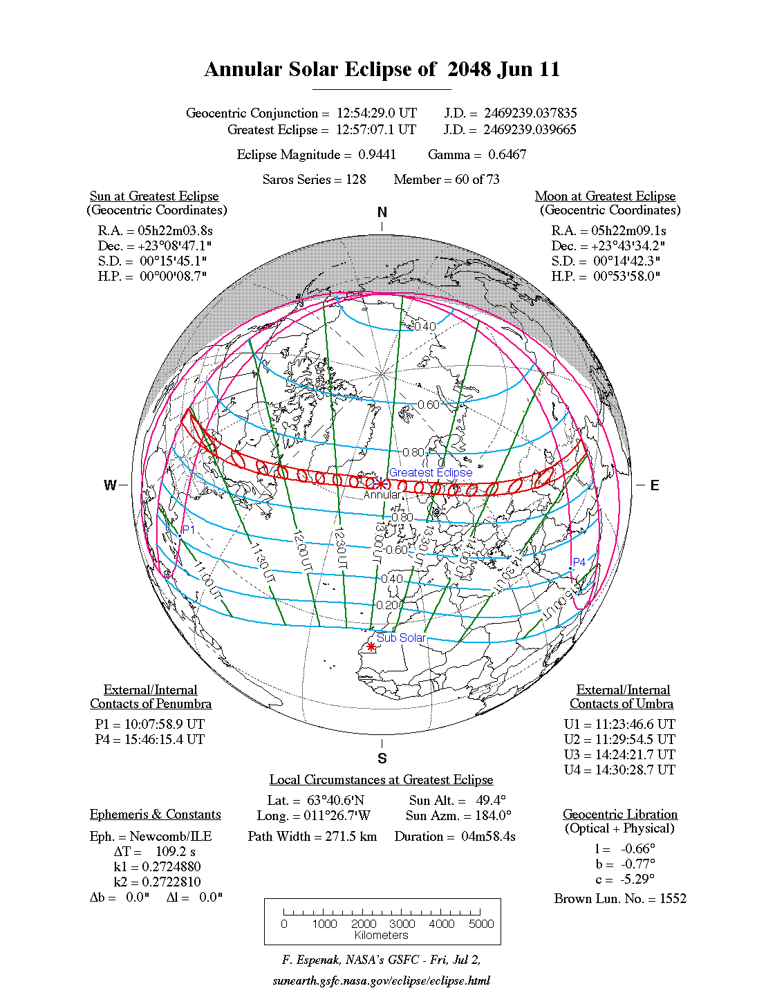
| Saros cycle | 128 (60 of 73) |
| Gamma value | +0.6467 |
| Greatest eclipse | |
| Duration | 4 minutes 58 seconds |
| place | Atlantic |
| location | 63 ° 41 ′ N , 11 ° 31 ′ W |
| time | June 11, 2048 12:57:07 UT |
| size | 0.9441 |

The annular solar eclipse of June 11, 2048 largely takes place over North America , Europe , Russia , North Africa and western Asia as well as the Arctic and the North Atlantic . Central America and the Caribbean experience the sunrise solar eclipse. The maximum of the eclipse is in the Atlantic about 200 km southeast of Iceland; the duration of the annular shape there is 4 minutes and 58 seconds.
course
The Annularity Zone begins at sunrise in the US state of Kansas and moves northwest through Iowa , Wisconsin, and Michigan to Canada. There, Ontario , Québec and Newfoundland are swept over before the zone reaches the Atlantic. The southern tip of Greenland is also in the annular zone, as is the southern half of Iceland and the northern coast of the Faroe Islands . In the early afternoon, Central Norway and Central Sweden , the densely populated parts of both countries, will experience the ring shape. The ring-shaped zone crosses the Baltic Sea and the Baltic States, with only Latvia being almost completely covered, as well as northern Lithuania and southern Estonia . The further path of the annular shape now runs along the borders between Russia and Belarus or the Ukraine before the Caspian Sea is reached. The rest of the ring-shaped zone stretches along the border between Turkmenistan and Kazakhstan or Uzbekistan . The eclipse ends at sunset in Afghanistan , with small parts of Tajikistan and Pakistan still being reached. For this eclipse, different assumptions of the Delta T (NASA: 90.7 s, Calsky: 71.6 s) when calculating the concrete course of the zone, result from the difference of approx. 19 s, deviations of up to 8 kilometers. As a result, downtown Milwaukee is within the toroidal path for NASA, but outside the path for Calsky.
Places in the ring-shaped zone
| country | place | Duration | Time ( UT ) | comment |
|---|---|---|---|---|
| United States | Omaha | 4m 7s | 11:28 | |
| United States | Des Moines | 4m 1s | 11:28 | |
| United States | Milwaukee | 0m 50s | 11:28 | |
| USA / Canada | Sault Ste. Marie (Ontario) , Sault Ste. Marie (Michigan) | 4m 18s | 11:33 | |
| Greenland | Qaqortoq | 4m 46s | 12:16 | |
| Iceland | Reykjavík | 4m 42s | 12:45 | |
| Faroe Islands | Viðareiði | 2m 38s | 13:04 | |
| Norway | Lillehammer | 4m 53s | 13:25 | |
| Norway | Oslo | 3m 15s | 13:27 | |
| Sweden | Västerås | 4m 50s | 13:33 | |
| Sweden | Stockholm | 4m 46s | 13:35 | |
| Sweden | Örebro | 4m 25s | 13:33 | |
| Estonia | Parnu | 2m 34s | 13:42 | |
| Latvia | Riga | 4m 43s | 13:45 | |
| Belarus | Vitebsk | 4m 36s | 13:52 | |
| Russia | Voronezh | 3m 58s | 14:04 | |
| Russia | Volgograd | 4m 13s | 14:11 | |
| Kazakhstan | Aqtau | 3m 49s | 14:21 | |
| Turkmenistan | Turkmenabat | 3m 40s | 14:25 | |
| Afghanistan | Kabul | 3m 31s |
- ↑ a b The sun rises partially darkened.
- ↑ With Calsky outside of the zone of the annularity
- ↑ The sun goes down partially eclipsed.
- ↑ The sun sets darkly immediately after the end of the ring shape
Visibility in German-speaking countries
The eclipse is visible in the German-speaking area, as a partial solar eclipse, throughout the course. The largest eclipse in the northeast is achieved in Sassnitz on Rügen with a maximum of 79% coverage. The lowest eclipse is achieved in the southwest in Zermatt in the Swiss canton of Valais , with a maximum of 52% coverage.
| country | place | cover | comment |
|---|---|---|---|
| Switzerland | Bern | 54% | |
| Switzerland | Basel | 56% | |
| Austria | Salzburg | 61% | |
| Austria | Vienna | 65% | |
| Germany | Munich | 61% | |
| Germany | Frankfurt am Main | 64% | |
| Germany | Berlin | 74% | |
| Germany | Hamburg | 74% |
Individual evidence
- ↑ NASA: Besselian Elements for the Annular Solar Eclipse of 2048 Jun 11
- ↑ CalSky: Local course of the solar eclipse, Thursday, June 11th, 2048 (possibly select location and click on solar eclipse )
- ↑ a b c The duration of the ring shape and the time of the middle of the ring shape were determined with the interactive map of NASA ( Annular Solar Eclipse of 2048 Jun 11, Google Maps and Solar Eclipse Paths )
Web links
- NASA: Annular Solar Eclipse of 2048 June 11
- NASA: Google Maps and Solar Eclipse Paths: 2041-2060
- Calsky, map for the solar eclipse on June 11, 2048
- NASA: Solar Eclipses of Saros 128
|
Previous solar eclipses:
|
Later solar eclipses:
|
|||||||||
| August 2, 2046 (total) |
January 26, 2047 (partial) |
June 23, 2047 (partial) |
July 22, 2047 (partial) |
December 16, 2047 (partial) |
June 11, 2048 (circular) |
December 5, 2048 (total) |
May 31, 2049 (circular) |
November 25, 2049 (hybrid) |
May 20, 2050 (hybrid) |
November 14, 2050 (partial) |
|
|
|
|
|
|
|
|
|
|
|
|
| Lists: 20th century • 21st century • All lists | ||||||||||