
City fortifications of Regensburg

North gate of the legionary camp, remains preserved
in the wall of the bishop's court
The walls and gates of the Roman legion camp Castra Regina were the first city fortifications of Regensburg . After the Romans left in the 5th century, the Roman wall and gates remained unchanged for about four centuries. Only after civil settlements had developed outside the Roman wall and monasteries had been built, further city fortifications were built in four periods, partially using the Roman wall, which were largely demolished in the middle of the 19th century:
- The Arnulfini city wall was built at the beginning of the 10th century.
- The medieval city wall was built in the early 14th century.
- In the 16th century the city wall was reinforced with 7 bastions .
- In the first half of the 17th century, during the Thirty Years' War , the outer works were built in front of the city wall.
- The removal of the city fortifications began at the end of the 18th century with the largely dilapidated external works. The Fürst-Anselm-Allee was built on the vacated site in front of the preserved city wall with a kennel and moat .
- From the middle of the 19th century, the demolition of the walls, towers and gates began, but significant parts of the former city fortifications were preserved. The bridge tower at the southern end of the stone bridge and the Ostentorturm have been completely preserved . Parts of the gate system of the Jakobstore and some sections of the city wall with two of the 37 wall towers have been preserved. The course and extent of the land-based city fortifications in the south of the city can be traced back to the Fürst-Anselm-Allee, which is partly disturbed by buildings and roads.

East: Salzstadel , West: Amberger barn and built-up remains of the medieval city wall on the Danube side; received: Ohmtür
Origin, course and description of the city fortifications
The wall of the Roman legionary camp Castra Regina and its remains

|

|
|
|
Remains of the eastern Roman wall (Kolpingstrasse) with a subsequent north-eastern curve at St.-Georgen-Platz
|
||
The 179 completed, 8-10 m high and 1.80 m wide Roman wall with its four corner towers and the 18 11 m high intermediate towers was such an impressive fortification that as late as the 8th century, contemporaries saw the city as an impregnable fortress. Their stones were reused to build the later new city walls. In the south and east even entire sections of the Roman wall were incorporated into the later city walls. In the basement to the east at Dachauplatz , the Roman wall is still visible today, below street level, at a length of 60 m and a height of 5 m. To the north of it, stones of the wall are even visible above ground such as B. in the course of the Kolpingstrasse to the north and especially good at the north-eastern curve at St.-Georgen-Platz, where the wall was built over by a house until 1905. The total of 2000 m long Roman wall had the shape of a rectangle with rounded corners and dimensions of 540 × 450 meters. In front of the wall was a 6 m wide and 3 m deep trench. The fort's defensive wall rested on a foundation, about 1 m high, beveled wall plinth. The processed cuboids of the defensive wall made of sand or limestone blocks were seamlessly connected without mortar. The seamless construction is still recognizable today from a section of wall that has been preserved in the basement and ground floor of the café at Peterstor.
The course of the Roman wall followed the course of the following streets, alleys and squares today:
- In the south: An der Hülling, St.-Peters-Weg, Fuchsengang, Am Königshof
- To the east: Dr.-Wunderle-Straße, Dachauplatz, Schwanenplatz, Adolph-Kolping-Straße, St.-Georgen-Platz
- In the north: Unter den Schwibbögen, Goliathstraße, Kohlenmarkt
- To the west: Wahlenstrasse, Obere Bachgasse, An der Hülling
Three of the four gates of the legionary camp, each with two passages and two towers, did not survive the later two city extensions and were demolished. The western gate, the Porta Sinistra , disappeared around 920 in the course of the first city expansion to the west and north, which was completed with the construction of the Arnulfini city wall. The northern gate, the Porta Praetoria , had lost its importance as a gate after the construction of the Arnulfini city wall, which also protected the northern area on the banks of the Danube with walls in the east and west, but was initially retained. After building a house over it, it fell into oblivion in the 1700 century and was only rediscovered at the end of 1885 when the building in front was demolished.
The eastern gate, the Porta Principalis Dextra, retained its function as a city gate, but was changed as the so-called black castle gate in the course of the Middle Ages. Just like the neighboring Poor Clare Monastery , the black castle gate was damaged by Napoleonic troops in the battle of Regensburg during the bombardment of the southeastern parts of Regensburg in 1809 and demolished in 1812.
The southern gate, the Porta decumana , at the southern end of the Fröhlichen-Türken-Straße, was changed and renamed to the so-called St. Paul Castle Gate in the course of the Middle Ages. It finally disappeared around 1320, when the Arnulfini city wall at this location was expanded into a medieval city wall with a kennel , kennel wall and moat, which made a completely new medieval gate system necessary, which was then called Weih St. Peters Tor .
The Arnulfini city wall (920-1320)

After the Romans withdrew in the 5th century, the wall of the legionary camp remained in place for several centuries. From 500 to 800 it offered protection to the dukes of the Bavarians from the Agilolfinger family , then the East Franconian Carolingian emperors and kings and after 900 also the Bavarian Duke Arnulf I from the Luitpoldinger family . In his time, the civil settlements outside the Roman wall to the west and north on the banks of the Danube were already well developed. Also outside the Roman wall, the Sankt Emmeram monastery was built after 739 in the southwest .
Around 920, after armed conflicts with the East Frankish King Konrad I , Duke Arnulf I decided to expand his Bavarian royal seat, which was enclosed by the Roman wall, and to expand the fortifications. The rectangular wall ring of the Roman legionary camp was broken open by the partial demolition of the north wall and west wall together with the Porta Sinistra. There the urban area was to be expanded to the north and west and secured by the new Arnulfinische city wall, which ran further west, and by 3 new gate towers.
At the place of today's St.-Georgen-Platz, where the Roman wall turned west from the south, the new Hallertor opened the eastern access to the city. A short wall up to the bank of the Danube was supposed to protect the northern bank zone of the city at the eastern end. The western end of the east-west traffic axis (today's Ludwigsstraße) was the new Ruozanburgtor , which led out to the then still large square of the later separate Arnulfsplatz and Bismarckplatz . In the northwest, the new city wall began on the banks of the Danube at the site of today's St. Oswald Church , the creation of which could be related to the construction of the city wall, but this is not clear. From there, the Arnulfinische Mauer ran south along today's Weißgerbergraben street, then followed the course of today's Drei-Mohren-Strasse and the Beraiterweg across the Aegidienplatz to the St. Emmeram monastery. The wall enclosed the monastery in a semicircle, interrupting it southeast of the monastery by the Old Emmeramer Tor , then ran a short distance to the north and joined the Roman wall again at the level of today's street An der Hülling. This protected both the St. Emmeram monastery and the civilian settlements to the west and north of the legionary camp.
The course of the Arnulfini city wall roughly followed the course of the following streets, alleys and squares today :.
- In the south (like the Roman wall): An der Hülling, St.-Peters-Weg, Fuchsengang, Am Königshof
- In the east (like the Roman wall): Dr.-Wunderle-Straße, Dachauplatz, Schwanenplatz, Adolph-Kolping-Straße, St.-Georgen-Platz with the new Hallertor
- In the north: Under the Schwibbögen, Goliathstrasse, Kohlenmarkt, Haidplatz (north side), Ludwigstrasse with the new Ruozanburgtor (clock tower Neue Uhr)
- To the west: Weißgerbergraben, Drei-Mohren-Straße, Beraiterweg, Aegidienplatz, Waffnergasse, circling the St. Emmeram Monastery
The medieval city fortifications (after 1293)
Description of the fortifications
The landside city fortifications in the west, south and east - without the outer works - had a total width of at least 40 m and consisted from the inside to the outside:
- Inner city wall with wall towers and gate towers, some of which were reinforced with defense towers. The city wall was approx. 2 m wide and 5 m high and provided with a covered battlement that led through the wall and gate towers. The 23 land-side and 14 Danube-side wall towers were square in floor plan, with a basement, mostly covered with pyramid roofs and had staircases leading to the battlements that led from the inner streets. The wall (without towers) was provided with around 1170 loopholes.
- Zwinger in front of the inner city wall: a strip of land up to 10 m wide overgrown with grass.
- Zwingermauer: a lower and only 1 m wide quarry stone wall, which was provided with lockable shooting holes. At regular intervals there were 28 semicircular or octagonal, inwardly open kennel turrets in the kennel wall. Zwingermauer and Zwingertürme had around 800 loopholes.
- City moat: In front of the Zwingermauer ran the approx. 20 m wide and up to 8 m deep city moat, supported on both sides by a lining wall made of rubble stones.
The Danube-side city fortifications in the north consisted only of the city wall with loopholes and some specially designed defense towers, some with passages through the wall, due to the special needs there on the banks of the Danube and the limited spatial conditions on the economically used Danube area.
Construction planning
At the end of the 13th century, the city had expanded to the west by approx. 500 m beyond the Arnulfini city wall. In this western suburb, the construction of the Schottenkloster St. Jakob had already started in 1110 , only 100 m from the Arnulfini Wall. Also outside the wall, 200 m further northwest, the Dominican convent Heilig Kreuz was founded in 1233 after the construction of a church by the Dominican monks had started a few years earlier inside the Arnulfini wall . The Romanesque hall church of Johanniter St. Leonhard was built in the middle of the west suburb in the middle of the 12th century , and further west in the alleys that still bear the name of their trade (Gerbergasse, Lederergasse ) had been driven in the 13th century of the city council settled the leather workers and tanners , who were dependent on the proximity to the Danube for the disposal of sewage. West of the working site where the settlement Prebrunn the sphere of influence of the company founded in 1100 monastery monastery Prüfening began, the influence of the imperial city of Regensburg ended.
With the Ostenvorstadt at the end of the 13th century, a new district was created in the east of the city, outside the Roman wall that still existed there. As early as 1221, in front of the former Porta Principalis Dextra , which had been converted into a black castle gate, the monastery of St. Salvator was founded as one of the first Franciscan monasteries in Germany. In place of a Salvator Chapel, the friars of the Franciscan Minorites began building the Minorite Church as a monastery church there from 1255 . Parallel to these buildings, a little south of them on the area of today's Dachauplatz was also a Clariss monastery . In addition, along the arterial road to Straubing, Passau and Vienna (today Ostengasse), many commercial enterprises, in particular breweries, inns and accommodation establishments. According to the monument protection list of the BLFD, many of today's houses have structures from the 2nd half of the 13th century and were then built over later.
Changes in the building stock of city wall towers and gate towers
During the construction of the medieval city wall, the following changes were made to existing towers:
- The old Emmeraner Tor of the Arnulfini city wall southeast of St. Emmeram Monastery was demolished.
- The Hallertor and the Ruozan castle gate of the Arnulfini city wall were preserved, but lost their function as a gate and were rededicated as clock towers (Haller clock and new clock).
Seven new gates with gate towers were built when the medieval city wall was built:
- the Prebrunn Gate
- the Jakobstor
- the New Emmeramer Tor west of St. Emmeram Monastery
- the Peterstor
- the Ostentor
- the Brückor (stone bridge south)
- the central tower on the stone bridge to secure access to the Upper Wöhrd
- the gate of the Black Tower (stone bridge north).
In the course of the city wall, 37 wall towers were built, which were renamed together with the gate towers under Prince-Bishop Dalberg and consecutively numbered with Roman numerals, starting in Prebrunn in the west and continuing on the Danube side to the east, then on the landside to the west.
Course of the landside medieval city fortifications
Towards the end of the 13th century, the decision was made that the east and west suburbs with all the newly built monasteries and churches and the stone bridge , which was completed in 1146 , should be included in the expanded fortifications of the city to be built. It was planned to build a city wall with a kennel , kennel wall and moat . The construction of the new landside city wall began in April 1293, as the inscription on a plaque in the Prebrunntorturm says, and was completed in 1320.
The landside city wall began in the west on the banks of the Danube in today's Herzogspark with the Prebrunn Gate Tower, which was part of the Prebrunn Bastion. The wall followed the course of today's Stahlzwingerweg road south to the gate of the Jakobstore, which was built around 1301 and of which only the two semicircular towers of the Vorwerk are preserved today. At the confluence of the Stahlzwingerweg in today's Jakobsstraße the multi-storey Jakobstorturm rose in the middle of the Jakobsstraße. The tower was connected on both sides by walls with two side storage buildings so that you could only pass the street through the opening of the gate and then find yourself in an inner courtyard. The passage over the moat was made via a drawbridge, which was reached through another gate, which was flanked by the two semicircular towers that are preserved today. The bridge was protected by a high defense tower attached to the southern half-round tower, which, like the Jakobstorturm, was not preserved.
- Preserved remains of the city wall, preserved gate towers and wall towers of the southern, landside city fortifications
Prebrunnturm II, north-east view; without bastion

Jakobstor XXXIV, flank towers of
the gate bridge over the city moat
Aegidian Tower XXXII
(west view)
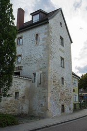
Emmeramer Tor XXXI
(south view)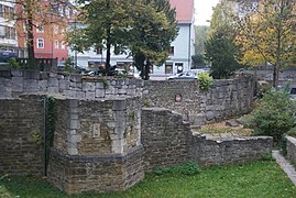
Roman wall and medieval city wall with Zwingermauer and Zwingerturm, location Am Königshof

Ostentor tower XVII
(east view)


.JPG)
.jpg)


.JPG)
From the Jakobstor to the southeast, the new city wall followed the course of today's narrow street Wiesmeierweg. The wall enclosed the Jakobskloster and then joined the old Arnulfini wall at the level of the Aegidienplatz. This enabled the old Arnulfini city wall, which ran from the bank of the Danube directly north to Aegidienplatz, to be torn down. Just like the old wall, the new one followed the course of the alley Am Ölberg to the south to the St. Emmeram monastery. In this section of the city wall, which is still well preserved today, there is the Aegidian tower, one of the two still preserved wall towers. The new Emmeramer Tor was built to the southwest of St. Emmeram Monastery , which, in continuation of the Am Ölberg alley, offered a southern exit to the city and was intended to establish a connection to the Bavarian suburb of Kumpfmühl . The Old Emmeramer Gate, not far to the northeast, was demolished. At the level of the street An der Hülling, a structure was built near the Placidusturm to allow the Vitusbach to pass through the wall. The Vitusbach had the task of supplying the planned moat with water. From there the new wall followed the course of today's Petersweg to the east, where the Arnulfinische Mauer and the partially preserved Roman wall also ran, initially to the St. Paul Castle Gate, the former Porta Decumana , which will be replaced by the new gate system of the Peter Gate had to. Then the new wall to the east continued to follow the Arnulfini or Roman wall along today's Fuchsengang street to the Am Königshof street, where the new and the two old walls turned north. While the two old walls ran further north, the new city wall turned sharply to the east after just 100 m at the height of today's Von-der-Tann-Straße to follow the course of this street and then after a change of direction at the street To enclose the new Ostenvorstadt up to the Ostentor at the strengzenbach to the north . There the wall ended on the Danube, where the Eastern Bastion was later built in 1529. The construction work to build the Zwinger, Zwingermauer and Stadtgraben began in 1330 at the Ostentor, as the inscription on a plaque there says. The lengthy construction work reached the new Peterstor in 1383 and was completed around 1400.
Course of the Danube-side medieval city wall
After completion of the construction work on the southern, landside city wall, construction of the northern, Danube-side city wall began in 1320, as the inscription on a plaque on Tower III of the city wall says.

The beginning of the wall in the east and the end of the wall in the west were supplemented and reinforced after 1500 with the east bastion and the west bastion (Prebrunnbastei).

|

|
|
|
Tower III (with southern annex) Herrenplatz 2
with inscription plaque for the start of construction |
||

.JPG)

With its 15 towers, the approx. 2 km long city wall on the Danube side ran along the shore zone, which was called Ländesstraße since 1885 and Donaulände since 1903 . To the west of the Stone Bridge , the Donaulände was used in very different ways as a storage and transhipment point for merchandise (wood, iron, wine, salt). This had to be taken into account when building the wall by providing sufficient space in front of the wall and different accesses and passages to the city. There is still a wall passage to the bank of the Danube just west of the Stone Bridge, formerly called the Ohmtürlein on Wiedfang. There, at the associated Ohm tower (IX, not preserved), the salt barrels were weighed and calibrated. There is a building board there, which says that the city wall along the Danube was repaired and strengthened in 1610. Then to the west, depending on the use, the gate systems and the affected wall areas had to be designed separately. There, the course of the wall was determined by the northern fronts of the farm and warehouse buildings, which were located there. The northern front of the former iron storage building (today: “the straw”) was formed by the city wall, which can still be recognized today by four loopholes over a length of 10 m. Also 300 m further east is a similar long section of the city wall with four loopholes as the northern front of two small sheds. Between these two sections of the wall, later demolitions, conversions and new constructions have greatly changed the original development. This applies e.g. B. for the building with the toll tower, where the goods had to be weighed to collect the toll, and also for the wine gate, which is now completely built in.
East of the stone bridge there was the Kräncherturm (XII) in front of the wall, a round tower with a crane attachment for loading and unloading processes. 500 m east of the stone bridge, access from the Donaulände to the Untere Wöhrd was via a wooden bridge secured with a wooden bridge tower, which was the forerunner of today's Iron Bridge . Even further east in the park of the royal villa is the only preserved city wall tower on the Danube side, which was called the Powder Tower and then the Anatomy Tower until the 19th century . Powder was stored in the tower, which was produced in a neighboring powder mill floating as far as possible from the city on the Danube .
Fortifications of the stone bridge

The main entrance to the city was the Stone Bridge , which was given a particularly representative, high and well-fortified tower with the city-side five-storey bridge tower . This southern city gate tower was badly damaged in the Thirty Years War and rebuilt in 1648. The access to the Upper Wöhrd in the middle of the bridge was given its own defense tower, the central tower . This tower, too, was burned out during the Thirty Years' War in 1633 during the Bavarian occupation and, like other fortifications on the Danube side, completely destroyed during the ice rush in 1784 and then removed. The northern bridge tower on the north bank of the Danube, the entrance to the Bavarian town of Stadtamhof , had to be specially protected as a highly endangered gate system. As early as 1383, the defense tower , known as the Black Tower , had a defense system surrounding it on three sides, which was expanded to form a four-walled area with battlements and loopholes in 1388 during the War of the Cities and in 1429 during the Hussite Wars , and also received two round accompanying towers and a ditch with a drawbridge in front. During the Thirty Years' War, at the beginning of the Swedish occupation in November 1633, the northern bridgehead of the Stone Bridge in its apron was additionally reinforced with a large hornwork with contregarde and three redoubts and deepened moats. The bridgehead could therefore not be taken by the imperial Bavarian troops despite heavy fire and multiple attacks. Nevertheless, the attackers reached the bridge in July 1634, because they had succeeded in conquering the Upper Wöhrd and occupying the bridge from there.
List of medieval city wall towers and gate towers
Numbering with Roman numerals according to Dalberg (quoted by Bauer)
| Tower name | Digit | location | description | Status | Remarks |
|---|---|---|---|---|---|
| Prebrunnbastei | I. | in the Herzogspark | Bastei complex without a tower, built in the 16th century; Fig. At | destroyed 1634 | New and heavily reinforced bastion built in 1656/8, the walls of which have been preserved |
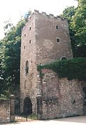
| Prebrunntor Tower | II | in the Herzogspark | four-storey tower with crenellated crown, basement inaccessible due to earthfill. | destroyed in 1634, reconstruction in 1642, preserved | since 1955 observation tower |
| Herrenplatz tower | III | Herrenplatz 2 | today installed in the corner house | built-in | with construction board |
| nameless | IV | Nordende Spatzengasse | with gate passage (muddy gate for removing rubbish) | not received | |
| Loh tower | V | across from house no. 16 Lederergasse | four-storey built into the wall with a pyramid roof and dormer window, loopholes in the basement | not received | Reinforced with blocks on the Danube side |
| Lederer Tower | VI | North end of Haaggasse | sitting on the wall with staircase and gateway to the Donaulände (Ledererthörl). | not received | probably canceled before 1812. Figure at |
| Tilting tower | VII | Near Brunnleite | Wall tower with box oriel on the third floor | not received | with arched wall passage for waste water. Figure at |
| Wood tower | VIII | North end of Weißgerbergraben | Wall tower in the bank reinforcement. Adjacent to the west is the wooden gate as access to the wooden area | not received | The Vitusbach spout under the tower |
| Eisengrät Tower | is missing | at house number 18, Keplerstrasse | massive tower | not received | pictured at HG Bahre 1630 View of the city from the north |
| Former wine gate | at house number 16, Keplerstrasse | not received | Wall gate with street gate built in 1610 | ||
| Former toll gate with toll tower | without no. | at house number 12, Keplerstrasse | walled up today | formerly with toll tower | |
| Interruption of the wall from house no. 10 Keplerstraße, with the former meat store and smelting works to the Am Wiedfang square | Meat house not received | Wall passage Fleischthürlein | |||
| Ohm tower | IX | just before the stone bridge | Round tower with conical roof and with wall passage Ohmtürlein | Tower not preserved, passage preserved | today: Ship's wind house (1914) with a slot for a pull rope |
| Bridge tower | X | South end stone bridge | representative city entrance and defense tower for the city wall and bridge | receive | |
| is missing | XI | ? | ? | ? | City wall with Wurstkuchl east of the Salzstadl |
| Kräncherturm | XII | On the Danube side below the Wurstkuchl | Round tower with crane attachment from 1617 | not received; | Figure at |
| without | XIII | South end of Hackengasse | ? | not received | ? |
| Wooden bridge tower | XIV | Near today's Iron Bridge | built with a drawbridge in 1418 as access to the Unterer Wöhrd . | not received; Figure at | West of the wall passage: Roßtürl. Demolished in 1854 |
| without | XV | south between Schattenofer- and Kapuzinergasse, 25 m south of the shore line | Foundations found during archaeological excavations (2009). Demolished probably before 1800 | not received | between Gichtl- and Schattenhofer-Gasse in front of the Salzstadl, passage through the city wall |
| from 1740 anatomy tower | XVI | west of the royal villa | Originally with a hipped roof and lavatory bay, around 1860 in a neo-Gothic style with battlements and a balcony | The only wall tower on the Danube side to be preserved | Called the Powder Tower until 1739 because of a powder mill in the Danube. Then called the Anatomy Tower and after 1812 again the Powder Tower. |
| Ostentorturm | XVII | Ostend of Ostengasse | representative gate tower with side towers | receive | The only preserved gate tower. Demolition after 1970 was prevented. Illustration with the east bastion and bastion towers |
| without | XVIII | on the grounds of the Albrecht Altdorfer Gymnasium | Quarry stone wall made of limestone | not received | The foundations of the city wall and a small wall tower were preserved in the basement of the school according to the list of architectural monuments in Regensburg-Ostnerwacht |
| Profosturm | XIX | on the area of house No. 26 Von-der-Tann-Straße | ? | not received | 1855 southern extension of a garden house in the kennel area |
| without | XX | on the area of house No. 14 Von-der-Tann-Straße | Quarry stone masonry with corner blocks, ogival two-arcade on the third floor | not received | Preserved photograph from 1870 |
| without | XXI | on the area of today's D.-Martin-Luther-Straße | ? | not received | Almost completely destroyed in 1809. Disappeared when D.-Martin-Luther-Strasse broke through the city wall |
| without | XXII | on the area of property no. 7 Am Königshof | ? | not received | There connection of the city wall to the congruent Roman wall. There excavation; Remains of the wall above ground are visible to the north |
| without | XXIII | on the area of property no. 6 Fuchsengang | Quarry stone mortared with corner blocks | not received | Foundation pushed into Roman wall; 3 m rising masonry according to excavation in 1993. Largely destroyed in 1809 |
| Hochwart Tower | XXIV | on the area of property no. 3 Petersweg | Part of the enclosure of the courtyard of the Peterstor with location in the Zwingermauer and half in the ditch | not received | Largely destroyed in 1809. In its place today a new tower house |
| without | XXV | South end of Fröhliche Türkenstrasse | Part of the enclosure of the armory of the Peterstor with entrance gate | not received | Largely destroyed in 1809. Illustration at |
| Pouring evil | XXVI | Petersweg | integrated into the city wall west of the armory of the Peterstor | not received | basement with dungeons and used as a prison. Largely destroyed in 1809. Illustration at |
| is missing | XXVII | ? | ? | ? | ?. |
| Astronomy or Placidus Tower | XXVIII | At the western end of Petersweg, where the course of the wall turns south | see photo from 1900 in | not received | Tower from 1812 Owned by Thurn und Taxis and made available as a place of residence and work for Abbot Placidus Heinrich . Not canceled until 1902. |
| is missing | XXIX | ? | ? | not received | ?. |
| is missing | XXX | ? | ? | not received | ?. |
| Emmeram Gate | XXXI | southern end of the streets Am Ölberg and Waffnergasse, where the course of the wall turns to the northwest | 3-storey gate tower with side towers | receive | Visible but not accessible within the Fürstenpark. Figure 1830 at |
| Aegidium tower | XXXII | west end of the street Aegidiengang | Multi-storey wall tower with lavatory bay, built into a 100 m long section of the city wall | the only wall tower preserved on the land side | Accessible in the inner courtyard of the old people's home. Illustration with the further course of the wall: to the west over the Wiesmeierweg to the Jakobstor, |
| Defense tower Jakobstor | XXXIII | To the south adjoining the Vorwerk from the two semicircular towers | Multi-storey defense tower next to the gate-bridge system, formed from the two preserved semicircular towers of the outer Jakobstore | not received. | Illustration of the floor plan of the entire facility when the tower was demolished before 1815 |
| Gate tower Jakobstor | XXXIV | In the middle of Jakobsstraße before the confluence of the Stahlzwingerweg, built into the city wall | Multi-storey gate tower, flanked to the south and north by two storage buildings and additional walls in such a way that between the outer gate of the two semicircular towers and the inner gate tower on the Zwinger grounds there was a closed arsenal that could only be reached through the gate in the gate tower. | not received. Northern warehouse building preserved, south today a residential building from 1829. | Figure floor plan of the entire facility |
| without | XXXV | House No. 17 Stahlzwingerweg | ? | only tower basement preserved | Location opposite Holy Cross Monastery |
| without | XXXVI | House No. 27 Stahlzwingerweg | ? | not received | ? |
| without | XXXVII | At the natural history museum location | ? | not received | Demolished in 1804 during the construction of the Württemberg Palace (today a natural history museum) |
Construction of the bastions in the 16th century
.JPG)
,_Nordseite.jpg)
Startled by the Turkish advance into Vienna in 1529, work began in the 16th century to strengthen the existing fortifications of the cities by building bastions . Bastions were earthworks in front of or behind the city wall, which could be supported by rectangular walls, bar or palisade fences and secured against fire with bulwarks . Bastions were used to raise guns, which, depending on the spatial and structural possibilities, could also be placed in battery towers on the bastion. Later, more modern bastions were round or had a pointed shape facing the enemy so that they no longer had a blind spot that could not be covered by the cannons. In Regensburg, the large eastern bastion on the Danube with two brick battery towers was first built to the northeast of the Ostentor at the site of today's Villa Park. The construction of another bastion in front of the western city wall at the height of the convent of the Dominican Sisters of the Holy Cross is on a building panel at the house Stahlzwingerweg described 23 for the year 1530th The construction of this cross bastion required large earth movements and burdened the citizens with tension services . In today's Fürstenpark west of the St. Emmeram Monastery, where a hill with a pavilion can still be seen, the Emmeram Bastion was built around 1555 behind the city wall in the rounding of the city wall there . The powder tower was also built here, in which not only powder but also balls were stored. This tower exploded in May 1624 after a lightning strike, which caused great damage in the area. As a further bastion, the strengzenbach bastion was built behind the rounding of the city wall near the alley at am strengzenbach . The last bastions were built in 1552, the Petersbastei , east of the Peterstor behind the curve of the south-east corner of the city wall at Am Königshof 7 and the Prebrunnbastei at the west end of the wall on the Danube bank. The cannons of the Petersbastei could cover the entire area of today's Ernst-Reuters-Platz .
The construction of the Prebrunnbastei was very complex and had unpleasant consequences for the residents and craftsmen of the suburb Prebrunn , which was outside the city wall but was economically closely connected to the city. In order to reach a sufficiently large bastion area at the west end of the wall with sufficient height for a bastion hill, the Prebrunntor tower was filled with earth so high that the gate passage in the basement was filled in and was no longer usable. During the Thirty Years' War, the Prebrunnbastei was fiercely contested and hardly defensible against fire from the Danube or the Upper Wöhrd. In the Swedish-occupied city, towards the end of the fighting for Regensburg, the Prebrunnbastei was almost completely destroyed by imperial Bavarian troops in July 1634 through shelling from the Upper Wöhrd. For the reconstruction after the war, the magistrate decided in 1665 to rebuild a considerably reinforced, larger and higher bastion with brick ring walls. It is these walls that you can find in the Herzogspark and that today show a state that was not present in the Thirty Years' War. The Prebrunn Gate remained closed even after the new bastion was built. As a replacement, a provisional passage through the city wall, called the Prebrunner Türl with a wooden bridge over the moat, was created at the Am Singrün square .
External works in front of the medieval city wall, built (1632–1634)
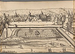
During the time of the Bavarian occupation of Regensburg in the Thirty Years' War in 1632/33 under the direction of the Nuremberg fortress builder Johann Carl in front of the city walls and gates in the south, east and west in the outer area in front of the city moat, various kinds of bulwarks , such as ravelins or horn works , built. They were supposed to protect and strengthen the now 300 year old city wall and the existing bastions. At the end of the construction work, 11 huge V- or M-shaped external works had been created, which surrounded the southern, landside city wall ring in a star shape and all of them can be seen on the merian engraving. The outer works extended 50 to 200 m into the apron of the city moat, so that the endangered sections of the city wall could be defended from the flanks of the outer works. The largest of the external works was in the apron of the Peterstor and extended to the current location of the mushroom kiosk
- External works in front of the landside, southern city wall. 1640, 6 years after the fighting
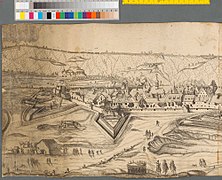
Prebunnbastei and Prebrunnturm (24), Kreuzbastei (21)

Jakobstor (17), (12) German Order Battery, Emmeramtor (8)

St. Emmeran-Batterie (6) to Obermünster


Obermünster to the beginning of the Peterstor outdoor works

Peterstor-Außenwerk (1) with sermon column

Peters Battery (K) with Petersfriedhof

Sterzenbach - Battery (C) Ostentor (A)


.jpg)
Right at the beginning of the Swedish occupation in November 1633, the unprotected eastern flank of Stadtamhof was also protected by defenses. Starting in the north in front of the city gate up to the mouth of the rain in the Danube, a ring of entrenchments was created, reinforced by ditches and palisades . On today's Grieser Spitz , a wooden bridge was even built over the rain at the mouth of the rain in the Danube, and a bridgehead was set up on the eastern bank occupied by Bavarian troops, which was protected by a hornwork. This facility was successfully used several times for raids by the Swedes into the camp of the Bavarian troops.
Removal of the city fortifications


At the end of the 18th century, city fortifications had lost their military importance. The removal of the city fortifications in Regensburg began with the outer works, which took up a lot of space in the run-up to the city wall and had fallen into disrepair over the years and overgrown with bushes. As early as 1779, Karl Anselm von Thurn und Taxis took the initiative to remove the external works. The external works were removed and parts of the moat filled in at the expense of the House of Thurn und Taxis. An avenue of trees, Fürst-Anselm-Allee, encompassing the old town to the south, was created on the vacated site . After 1806, at the suggestion of Prince Primate Karl Theodor von Dalberg, it was expanded and upgraded with monuments. In some cases, the use of the kennel and moat to create gardens was tolerated without the city and kennel walls being removed. Only after 1803 began isolated demolitions of facilities, combined with the sale and use of the land gained. The cathedral capitular and botanist Kaspar Maria von Sternberg acquired the large area of the outer works in front of the Peterstor, which extended to today's mushroom kiosk . There he had a garden laid out for the Botanical Society in 1805 and a garden palace built. After severe damage in 1809 and after the site was sold to Karl Alexander von Thurn und Taxis, the palace was converted into a garden palace called Theresens Ruh .
In 1809, the southern city wall east of the Peter Gate was once again used for war. In the battle of Regensburg , retreating Austrian troops had holed up on the battlements of the south wall. They initially defended themselves successfully against attacking French troops, who were only able to overcome the moat after it had been filled with the rubble of a collapsing building. The Austrian troops fled and the French artillery laid the entire southeastern district of Regensburg to rubble and ashes. To protect the Austrian troops who had withdrawn over the Stone Bridge to Stadtamhof, the Austrian artillery fired at the following French troops from the northern heights. The town of Stadtamhof was destroyed, as was the northern bridgehead of the Stone Bridge, the Black Tower . The destroyed gate tower was demolished in the same year. In a city map from this time, only 22 of the former 37 towers of the city wall are still registered.
From 1812 the demolition of the upper parts of the Danube-side city wall began, repeatedly interrupted by objections from the War Ministry of the new Kingdom of Bavaria , to which the Prince-Bishopric of Regensburg fell under Karl Theodor von Dalberg in 1810. The planned demolition of the city walls and city gates also met with resistance from King Ludwig I , who visited Regensburg in 1830 and campaigned for the preservation of the old defensive walls. Large parts of the city wall remained in place well into the 19th century and were used by winches to wind their ropes, and by walkers and children as places of entertainment. The preservation of the walls caused high costs for the city treasury and led to fatal accidents and falls into the city moat among the population, even after lanterns were erected in 1827. It was not until 1856 that the city's magistrate finally decided to demolish the entire city wall, starting with the wall on the Danube side. But it was not until 1858 that King Maximilian II gave his consent to the demolition. For the southern, landside wall, the royal approval was not given until 1863. Under the ambitious mayor Oskar von Stobäus , who was in office from 1868, all walls, towers and gates were demolished with a few exceptions, because it was clear to him that by demolishing the walls and Filling the trench, extensive plots of land could be obtained in order to be able to implement the school and road construction program planned by him. First, in 1868, after the breakthrough of the city wall on Klarenanger, the newly built D.-Martin-Luther-Straße provided access to the train station . Not far to the north-west of it, the new high school was built in 1880 on the site of the demolished city wall and kennel . In 1889 the city moat was filled and the Minoritenweg was extended with the newly built Reichsstraße. The first new Wilhelminian-style district outside the medieval city center was built there on a chessboard-like floor plan .
Only the Ostentorturm was completely preserved . Many of the foundations of the city wall were preserved, which were then built over with new houses, as in Petersweg, Fuchsengang, Von-der-Tann-Straße and Wiesmeierweg. Only a few sections of the city wall were preserved above ground without a battlement. B. clearly visible in the back yard of the Aegidien Church on Aegidienplatz , there even with a wall tower. Today the course and extent of the southern city fortifications can still be traced on the basis of the Fürst-Anselm-Allee between Maximilianstrasse and D.-Martin-Luther-Strasse, which is partly disturbed by buildings . At Maximilianstrasse , excavations in 1955/60 uncovered the south-east curve of the Roman wall, which in this section ran exactly like the Arnulfinische and the medieval city wall. A piece of the medieval Zwingermauer with an octagonal Zwingerturm was exposed there, which partly reached into the former city moat.
List of visible remains of the city fortifications
The list begins on the southern bank of the Danube, following the course of the former city wall first from west to east, then south and west again.
- Herzogspark with Prebrunnbastei (I) and Prebrunntorturm (II). The clearly reinforced bastions that are visible today were not built until after 1655.
- Herrenplatz Nr. 2: City wall with built-in tower (III), three-storey, gable-independent gable roof, quarry stone, with southern extension and inscription plaque for the construction of the wall, marked 1320
- Keplerstraße 12, 14, 16, 18: City wall with remains of the wine gate
- Lederergasse 20: city wall
- Quarry stone masonry of the city wall made of limestone and sandstone can be found in the course of the local house walls on the banks of the Danube; loopholes can be seen near the stone bridge.
- At the second catch no. 1 to no. 7: City wall, at no. 7 a passage through the city wall, the Ohmtor, the former location of the Ohm Tower (IV).
- Remnants of the city wall as the south wall of today's historic sausage kitchen, where sausages have been offered since 1812 (sausage roaster, sausage kuchl)
- City wall (part of the park of the Royal Villa) with anatomy tower (XVI), remodeled in a neo-Gothic style in 1861
- Adolf-Schmetzer-Straße Nr. 1: trains of the city wall with moat and moat lining wall in the course of the Ostentor with gate tower to the Danube, Zwingermauer with shell turrets, east bastion (Villapark)
- Lehnerweg No. 1 Zwingermauer

- Von-der-Tann-Straße No. 4 to No. 8 and No. 18: City wall and Zwingermauer with little kennel tower under the south facade of the houses
- Am Königshof, Ernst-Reuter-Platz: Zwingermauer with shell tower and city wall / Roman wall
- Fox corridor No. 2b: section of the wall with Roman spoilage
- At Peterstor 3: Remains of the city wall (Roman wall) with moat, moat lining wall and bridge at Peterstor
- In the Fürstenpark: hill with masonry of the former Emmeram bastion
- Waffnergasse southern end: Emmeramer Tor and bridge over the former city moat, whereby the Helenentor (built in 1909) reproduces the course of the former city wall.
- West end of the cul-de-sac Aegidiengang and there the passage to the inner courtyard: 150 m city wall (quarry stone masonry, 14th century) with Aegidien tower (XXXII) with coffin on corbels
- Wiesmeierweg with parts of the city wall, kennel wall and lining wall of the city moat, partly also in the garden of houses No. 9, 11, 13, 15, 17, 17a, 19, 21
- Today's Jakobstor consists of the two semicircular towers, which were redesigned in a neo-Gothic style after 1815 and then again heavily modified in 1903 and 1957, which previously only flanked the former outer gate with the drawbridge over the moat. The former actual Jakobstorturm (XXXIII) stood in the middle of Jakobsplatz in front of the confluence of the Stahlzwingerweg, which followed the course of the city wall to the north. The current hotel building was the northern part of the fence around the gate courtyard.
- Stahlzwingerweg north of the hotel building to No. 5: a 70 m long section of the 4 m high kennel wall
- Stahlzwingerweg and Prebrunnallee: parts of the city wall, kennel wall and lining wall of the moat can be found in many house, cellar and garden walls.
Web links
- List of monuments for Regensburg (PDF) at the Bavarian State Office for Monument Preservation
- Bavarian Monument Atlas (cartographic representation of the Bavarian architectural and ground monuments by the BLfD , requires JavaScript)
Remarks
- ↑ In the consecutive numbering of the towers with Roman numerals according to Dalberg, the Prebrunnbastei has the number I. Therefore, the Prebrunntorturm was given the number II. The further numbering is continued with the Danube-side towers at Dalberg, so that the Prebrunnbastei does not belong to the landside, but is one of the towers on the Danube side
- ↑ Today's Schottenstrasse, which extends Kumpfmühlerstrasse to Bismarckplatz, did not exist back then.
- ↑ Today's Maximilianstrasse did not exist back then.
- ↑ Swabian expression for a perforated wooden box with which people were submerged under water.
- ↑ Today's Helenenstraße existed from 1908.
- ↑ Today's Schotten-Kumpfmühlerstaße did not exist until 1863.
- ↑ The semicircular towers were changed several times during the Neo-Gothic period . Pseudo-Gothic tracery windows and battlements were built in, the old front gate removed, two pedestrian gates and a pointed arched passage built in, which had to be removed again in 1903 for the overhead line of the tram. Most of the parts of the neo-Gothic remodeling disappeared in 1957.
- ↑ The course of the Regen river is not correctly reproduced on the engraving, the rain runs further east from Stadtamhof
- ↑ It is thanks to the efforts of the Regensburg citizen Horst Bergschneider that these remains of the wall were preserved in the post-war years after 1950 despite the new building projects planned at the time .
Individual evidence
- ^ Karl Bauer: Regensburg Art, Culture and Everyday History . 6th edition. MZ-Buchverlag, Regenstauf 2014, ISBN 978-3-86646-300-4 , p. 96-99, 526-533 .
- ^ Karlheinz Dietz, Udo Osterhaus, Sabine Rieckhoff-Pauli, Konrad Spindler: Regensburg in Roman times . Friedrich Pustet, Regensburg 1979, ISBN 3-7917-0599-7 , pp. 192-195 .
- ^ Karl Bauer: Regensburg Art, Culture and Everyday History . MZ-Buchverlag, Regenstauf 2014, ISBN 978-3-86646-300-4 , p. 45 f .
- ^ Karl Bauer: Regensburg Art, Culture and Everyday History . MZ-Buchverlag, Regenstauf 2014, ISBN 978-3-86646-300-4 , p. 540 .
- ^ Peter Morsbach: Evang.-Luth. St. Oswald Church Regensburg . In: Förderverein Dreieinigkeitskirche and St. Oswald Church (ed.): Schauplätze. On the way through Bavaria's history . Dr. Peter Morsbach Verlag, Regensburg 2007, ISBN 978-3-937527-12-3 , pp. 6 .
- ^ Karl Bauer: Regensburg Art, Culture and Everyday History . MZ-Buchverlag, Regenstauf 2014, ISBN 978-3-86646-300-4 , p. 408, 527-533 .
- ^ A b Dieter Albrecht: Regensburg im Wandel, studies on the history of the city in the 19th and 20th centuries . In: Museums and Archives of the City of Regensburg (Hrsg.): Studies and sources on the history of Regensburg . tape 2 . Mittelbayerische Druckerei und Verlags-Gesellschaft, Regensburg 1984, ISBN 3-921114-11-X , p. 198 .
- ^ Karl Bauer: Regensburg Art, Culture and Everyday History . MZ-Buchverlag, Regenstauf 2014, ISBN 978-3-86646-300-4 , p. 530 ff .
- ^ Karl Bauer: Regensburg Art, Culture and Everyday History . MZ-Buchverlag, Regenstauf 2014, ISBN 978-3-86646-300-4 , p. 425 f .
- ^ Karl Bauer: Regensburg Art, Culture and Everyday History . MZ-Buchverlag, Regenstauf 2014, ISBN 978-3-86646-300-4 , p. 40, 46 .
- ^ Karl Bauer: Regensburg Art, Culture and Everyday History . MZ-Buchverlag, Regenstauf 2014, ISBN 978-3-86646-300-4 , p. 393 f .
- ↑ List of monuments for Regensburg (PDF) at the Bavarian State Office for Monument Preservation
- ^ A b Karl Bauer: Regensburg Art, Culture and Everyday History . MZ-Buchverlag, Regenstauf 2014, ISBN 978-3-86646-300-4 , p. 530 ff .
- ^ Karl Bauer: Regensburg Art, Culture and Everyday History . MZ-Buchverlag, Regenstauf 2014, ISBN 978-3-86646-300-4 , p. 542 f .
- ^ Karl Bauer: Regensburg Art, Culture and Everyday History . MZ-Buchverlag, Regenstauf 2014, ISBN 978-3-86646-300-4 , p. 529 above, 530 below .
- ^ Karl Bauer Hrsg =: Regensburg art, culture and everyday history . MZ-Buchverlag, Regenstauf 2014, ISBN 978-3-86646-300-4 , p. 404, 545 f., 224 .
- ^ Karl Bauer: Regensburg Art, Culture and Everyday History . MZ-Buchverlag, Regenstauf 2014, ISBN 978-3-86646-300-4 , p. 545, 221, 787, 220 f .
- ↑ Peter Engerisser, Pavel Hrnčiřík: The battle near Nördlingen - turning point of the Thirty Years' War. Verlag Späthling, Weißenstadt 2009, ISBN 978-3-926621-78-8 .
- ↑ Peter Engerisser A previously unknown view of the siege of Regensburg in 1634. In: Negotiations of the Historical Association for Upper Palatinate and Regensburg. 148th Volume, Regensburg 2008, pp. 73, 74; ISSN 0342-2518 ( online ; PDF; 2.1 MB).
- ↑ a b c d e f g h i j k l Karl Bauer: Regensburg art, culture and everyday history . MZ-Buchverlag, Regenstauf 2014, ISBN 978-3-86646-300-4 , p. 535-546, 973 .
- ^ Karl Bauer: Regensburg Art, Culture and Everyday History . MZ-Buchverlag, Regenstauf 2014, ISBN 978-3-86646-300-4 , p. 530, 973 .
- ↑ Silvia Codreanu-Windauer, Uta Kirpal: Donaulände, discovery of the city wall tower XV . In: City of Regensburg, Office for Archives and Preservation of Monuments (ed.): Preservation of monuments in Regensburg . tape 12 . Friedrich Pustet, Regensburg 2011, ISBN 978-3-7917-2371-6 , pp. 162 f .
- ^ Karl Bauer: Regensburg Art, Culture and Everyday History . MZ-Buchverlag, Regenstauf 2014, ISBN 978-3-86646-300-4 , p. 178 .
- ^ Peter Morsbach: The cityscape of Regensburg in the 16th century . In: Working Group Regensburg Autumn Symposium (ed.): “Between Gothic and Baroque” traces of the Renaissance in Regensburg . tape 26 . Dr. Peter Morsbach Verlag, Regensburg 2012, ISBN 978-3-937527-55-0 , p. 29 f .
- ^ Karl Bauer: Regensburg Art, Culture and Everyday History . MZ-Buchverlag, Regenstauf 2014, ISBN 978-3-86646-300-4 , p. 522 f .
- ^ Karl Bauer: Regensburg Art, Culture and Everyday History . MZ-Buchverlag, Regenstauf 2014, ISBN 978-3-86646-300-4 , p. 534 f .
- ↑ Eugen Trapp: Prebrunn, "formerly a funny suburb" Obituary for an ensemble that was never entered in the list of monuments . In: City of Regensburg, Office for Archives and Preservation of Monuments (ed.): Preservation of monuments in Regensburg . tape 13 . Friedrich Pustet, Regensburg 2014, ISBN 978-3-7917-2550-5 , pp. 191-192 .
- ^ A b Karl Bauer: Regensburg Art, Culture and Everyday History . MZ-Buchverlag, Regenstauf 2014, ISBN 978-3-86646-300-4 , p. 536 ff .
- ↑ Peter Engerisser A previously unknown view of the siege of Regensburg in 1634. In: Negotiations of the Historical Association for Upper Palatinate and Regensburg. 148th Volume, Regensburg 2008, pp. 67f, 75; ISSN 0342-2518 ( online ; PDF; 2.1 MB).
- ↑ In honor of Horst Bergschneider. Retrieved September 24, 2019 .