
Stanwood (Washington)
| Stanwood | |||
|---|---|---|---|
 Looking west on Main Street |
|||
| Location in Washington | |||
|
|||
| Basic data | |||
| Foundation : | October 19, 1903 ( incorporated , i.e. recognized as a local authority ) | ||
| State : | United States | ||
| State : | Washington | ||
| County : | Snohomish County | ||
| Coordinates : | 48 ° 15 ′ N , 122 ° 21 ′ W | ||
| Time zone : | Pacific ( UTC − 8 / −7 ) | ||
|
Inhabitants : - Metropolitan Area : |
6,779 (as of 2015) Metropolitan Area Seattle |
||
| Population density : | 928.6 inhabitants per km 2 | ||
| Area : | 7.36 km 2 (approx. 3 mi 2 ) of which 7.30 km 2 (approx. 3 mi 2 ) is land |
||
| Height : | 2 m | ||
| Postal code : | 98292 | ||
| Area code : | +1 360 | ||
| FIPS : | 53-67455 | ||
| GNIS ID : | 1512690 | ||
| Website : | City of Stanwood | ||
| Mayor : | Leonard Kelley | ||
 Location of Stanwood in Snohomish County |
|||


Stanwood is a city ( City ) in Snohomish County in the State of Washington . In the Lushootseed Stanwood is called: Sŭl-gwähs' . The city is located about 80 km north of Seattle at the confluence of the Stillaguamish River in the Puget Sound . At the 2010 United States Census , Stanwood had 6,231 residents.
history
Before the exploration and colonization by Europeans in the 19th century, the region was on Puget Sound from the Coast Salish peoples attributed Indians settled. Today's Downtown Stanwood was the home of the Stillaguamish , led by Chief Zis-aba , who lived in a village called Sŭl-gwähs' with an estimated 250 inhabitants and three large potlatch houses. George O. and GL Wilson were led up the Stillaguamish River on a canoe expedition by Samuel Hancock in 1851 and were the first Americans of European descent to explore the river.
Stanwood was first settled in 1866 by Robert Fulton and was initially called "Centerville". The Stanwood Post Office was established as Centerville in 1870; the name was changed in 1877 by DO Pearson after his wife's maiden name in Stanwood. Stanwood was officially recognized as a local authority on October 19, 1903, and grew at the mouth of the Stillaguamish River a mile (1.6 km) west of the tracks of the Seattle-Montana Great Northern Railway, founded in 1891 . The H and H Railroad connected the place with the station since 1904. East Stanwood (along the railroad tracks) was parceled out in 1906 and recognized in 1922. The two cities were united in 1960.
Historic buildings
Two buildings in Stanwood are listed on the National Register of Historic Places :
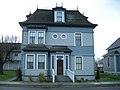
DO Pearson House, circa 1890, now part of the Stanwood Area History Museum .

Stanwood IOOF Public Hall, 1903, now the Floyd Norgaard Cultural Center .


geography
According to the United States Census Bureau , the city has a total area of 7.36 km², of which 7.3 km² are land and the rest are water. The city is located in the northwest of Snohomish County, and is considered part of the metropolitan area of Seattle . Stanwood is about 50 miles north of Seattle, and about 13 miles west of Arlington , the nearest city.
Stanwood lies at the confluence of the Stillaguamish River with Port Susan, an arm of Puget Sound , and Skagit Bay, the mouth of the Skagit River . To the west is Davis Slough , which separates Stanwood from Camano Island , and forms the border between Snohomish County and Island County . Altitudes in Stanwood range from about 60 cm above sea level on the Stillaguamish River to about 58 m in the northeastern hills. There are five rivers in the city with a drainage basin that flows into the Stillaguamish River and Puget Sound: Church Creek, Douglas Creek, Irvine Slough, and the Skagit River and Stillaguamish River.
Stan Woods city boundaries are generally defined by the Stillaguamish River in the south, the 104 th Drive Northwest in the west, the 276 th Street Northwest and the 290 th Street Northwest in the north and 68 th Avenue Northwest in the east. The Stanwood Urban Growth Area consists of an additional 172 hectares outside the city limits that includes the unincorporated Northwest Stanwood area .
The Stanwood area was formed in the Pleistocene and later modeled by the rise and fall of sea levels and the sedimentation of the Skagit and Stillaguamish Rivers. Much of downtown Stanwood is in a flood- threatened zone that belongs to both the Skagit and the Stillaguamish Rivers.
Neighboring communities
| Skagit Bay | Conway | Lake McMurray |
| Camano Island |
.svg)
|
Arlington |
| Port Susan | Warm Beach | Silvana |
Legislative and Executive
Stanwood is ruled by a mayor and a city council.
There is a contract with the Snohomish County Sheriff's Office for police services. The deputy ( deputies ) of the sheriffs who are seconded to the road patrol in Stanwood, driving the patrol car with the logo of the city. There are currently 6 patrol officers , a school resource officer , a detective, three constables and a department head who are assigned to the city full-time.
Demographics
| year | Residents¹ |
|---|---|
| 1910 | 544 |
| 1920 | 704 |
| 1930 | 715 |
| 1940 | 600 |
| 1950 | 710 |
| 1960 | 646 |
| 1970 | 1,347 |
| 1980 | 1,646 |
| 1990 | 1.961 |
| 2000 | 3,923 |
| 2010 | 6.231 |
| 2016 | 7.009 |
¹ 1910-2010:
2016 Census Results: United States Census Bureau estimate
2010 Census
According to the 2010 census , Stanwood had 6,231 residents, 2,388 households, and 1,541 families. The population density was 853.1 per km ². There were 2,584 housing units at an average density of 353.8 per km².
The population was 89.7% white , 1% African-American , 0.8% Native American , 1.7% Asian , 0.3% Pacific islanders , and 2.6% others "Races" and 3.9% from two or more "Races" . Hispanics or Latinos of "any race" made up 7% of the population.
Of the 2,388 households, 38% had children under the age of 18, 47.7% were run by married couples living together , 12.1% by single mothers and 4.7% by single fathers; 35.5% were non-families. 29.6% of the households were singles and 16.2% were single persons over 65 years of age. The average household size was 2.55 and the average family size was 3.18.
The median age in the city was 35.9 years. 28.1% of the population were under 18, 8% between 18 and 24, 27.2% between 25 and 44, 21.3% between 45 and 64 and 15.3 65 years or older. 47.3% of the population were men and 52.7% women.
Census 2000
As of the 2000 census , Stanwood had 3,923 residents, 1,402 households, and 957 families. The population density was 768.9 per km ². There were 1,508 housing units at an average density of 295.6 per km².
The population was 91.56% White , 0.59% African American , 0.94% Native American , 1.1% Asian , 0.23% Pacific Islander , 2.52% from other "races" and 3.06% from two or more "races" . Hispanics or Latinos of "any race" made up 4.97% of the population.
Of the 1,402 households, 42.3% had children under the age of 18, 51.3% were run by married couples living together, and 12.3% by single mothers; 31.7% were non-families. 26.7% of the households were singles and 13.8% were single persons over 65 years of age. The average household size was 2.65 and the average family size was 3.22.
The median age in the city was 34 years. 31.5% of the population were under 18, 6.6% between 18 and 24, 30.6% between 25 and 44, 14.5% between 45 and 64 and 16.9 65 years or older. There were 89.9 men for every 100 women, and 81.2 men for every 100 women over the age of 18.
All information on median income relates to the median. The median household income was US $ 44,512 compared to US $ 52,996 for families. Men had a median income of US $ 40,457 compared to US $ 26,738 for women. The per capita income was US $ 16,775. About 9% of families and 12% of the total population lived below the poverty line ; this affected 8.9% of those under 18 and 23.4% of those over 65.
traffic
Stanwood is on Washington State Route 532 , an east-west highway that connects Camano Island with Interstate 5 east of Stanwood. The city is also served by two other major arteries: the Pioneer Highway , historically part of Washington State Route 530, and the Pacific Highway ( US Route 99 ), which runs north to Conway and east to Arlington ; and Marine Drive , which continues to Warm Beach , the Tulalip Indian Reservation and Marysville to the south.
Public transportation in Stanwood is operated by Community Transit and Island Transit , the transportation companies for Snohomish and Iceland Counties. Community Transit offers daily bus services to Warm Beach, North Lakewood and Smokey Point . During peak hours, there is also an express service for commuters to the Boeing Everett facility and downtown Seattle from two park and ride locations in the Stanwood area. Island Transit offers two routes to Camano Island, as well as a commuter service to Mount Vernon and Everett .
A railway line operated by the BNSF Railway runs through Stanwood in a north-south direction, bringing freight and passenger traffic into the city. Amtrak Cascades offers a passenger connection from Stanwood Station in downtown Stanwood south to Seattle and north to Vancouver (British Columbia) . The station opened on November 21, 2009 when passenger traffic that had been interrupted since 1971 was resumed.
education
Public schools in Stanwood are operated by the Stanwood-Camano School District , which covers the city and neighboring parishes; this also includes Camano Island , Lake Ketchum, and Warm Beach. The district served approximately 4,554 students in 2014 and operates a total of eleven schools, including one high school, two middle schools, and four elementary schools in Stanwood.
Stanwood's closest higher education institutions are Skagit Valley College in Mount Vernon and Everett Community College in North Everett.
Personalities
- Bundle of Hiss - a grunge ribbon
- Fanny Cory - artist and illustrator
- TJ Oshie (* 1986) - Washington Capitals center player and US Olympian
- Eugene H. Peterson (born 1932) - clergyman and author
- Ted Richards - American football player
- Zakarias Toftezen - early pioneers
- Francesca Woodman (1958–1981) - photographer
Individual evidence
- ^ Population Estimates . United States Census Bureau . Archived from the original on October 19, 2016. Info: The archive link was automatically inserted and has not yet been checked. Please check the original and archive link according to the instructions and then remove this notice. Retrieved June 25, 2016.
- ↑ Prasse, Karen. River, Rail, & Road A Pictorial History of Stanwood & East Stanwood, Washington. Stanwood, Wash: Stanwood Area Historical Society, 2003.
- ^ A b Herbert Hunt, Floyd C. Kaylor: Washington, West of the Cascades: Historical and Descriptive . SJ Clarke Publishing Company, Chicago 1917, pp. 395-398, 534, OCLC 10086413 ( Accessed April 24, 2017).
- ↑ 2010 City Population and Housing Occupancy Status . US Census Bureau. Retrieved December 9, 2012.
- ↑ Jan L. Hollenbeck, Madonna Moss: A Cultural Resource Overview: Prehistory, Ethnography and History: Mt.Baker-Snoqualmie National Forest . United States Forest Service , 1987, p. 153, OCLC 892024380, (Retrieved April 24, 2017).
- ↑ Lucile McDonald: Two of Stillaguamish River's 3 Mouths Threatened by Siltation . In: The Seattle Times , Dec. 8, 1957, p. 5.
- ↑ Harry M. Majors: Exploring Washington . Van Winkle Publishing Co, 1975, ISBN 978-0-918664-00-6 , p. 18.
- ^ Edmond S. Meany: Origin of Washington geographic names . University of Washington Press, Seattle 1923, p. 287.
- ↑ a b c Snohomish County Natural Hazard Mitigation Plan Update, Volume 2: Planning Partner Annexes . Snohomish County. September 2015. Accessed April 24, 2017.
- ↑ US Gazetteer files 2010 . United States Census Bureau . Archived from the original on January 24, 2012. Info: The archive link was automatically inserted and not yet checked. Please check the original and archive link according to the instructions and then remove this notice. Retrieved December 19, 2012.
- ^ Snohomish County (March 2013). Snohomish County Urban Growth Areas and Incorporated Cities [map]. Retrieved July 1, 2017.
- ↑ Select Stanwood . City of Stanwood. Retrieved July 1, 2017.
- ^ Community Profiles: Stanwood . Northwest Fisheries Science Center. Retrieved April 24, 2017.
- ^ A b c Snohomish County, Washington Flood Insurance Study . Snohomish County. Pp. 16-17. 2005. Retrieved July 1, 2017.
- ^ Arnold O. Ness, CG Richins, Ray Carlton Roberts: Soil Survey of Island County, Washington . United States Department of Agriculture, Soil Conservation Service. August 1956. Retrieved July 1, 2017.
- ↑ RCW 36.04.310: Snohomish county . In: Revised Code of Washington . Washington State Legislature. Retrieved July 1, 2017.
- ↑ a b City of Stanwood Stormwater Comprehensive plan Appendix C . City of Stanwood. 2014. Retrieved July 1, 2017.
- ↑ City of Stanwood (June 2016). Stanwood Streets and Parcels [map]. Retrieved July 1, 2017.
- ^ City of Stanwood Comprehensive Plan . City of Stanwood. June 2015. Accessed July 1, 2017.
- ^ Kari Bray: Worried about flood risks, Stanwood is heading for the hills . In: The Everett Herald , October 18, 2014. Retrieved July 1, 2017.
- ↑ United States Census Bureau : Census of Population and Housing . Retrieved July 26, 2013.
- ^ Population and Housing Unit Estimates . Retrieved June 9, 2017.
- ↑ American FactFinder . United States Census Bureau . Retrieved December 19, 2012.
- ^ Washington State Department of Transportation (2014). Washington State Highways, 2014–2015 [map]. Grid square C3. Retrieved July 2, 2017.
- ^ Portion of 530 will be called Pioneer Highway . In: The Seattle Times , June 4, 1992, p. E2. Retrieved July 2, 2017.
- ↑ Thomas Brothers (1938). Highway Map, State of Washington [map], 1: 1,360,009. Retrieved July 2, 2017.
- ^ The Pacific Highway . In: Western Motor Car (Ed.): Western Motor . IX, No. 2, Seattle, July 1917, p. 22. Retrieved July 2, 2017.
- ^ A b c City of Stanwood Transportation Plan . City of Stanwood. March 2015. Retrieved July 2, 2017.
- ↑ Marine Drive Corridor Improvements Final Environmental Impact Statement . Snohomish County Department of Public Works. October 1983. Retrieved July 2, 2017.
- ↑ Community Transit Bus Plus: Schedules & Route Maps . Community Transit, March 12, 2017 (Accessed July 2, 2017).
- ^ Community Transit (September 2016). Community Transit System Map . Retrieved July 2, 2017.
- ^ Gale Fiege: Stanwood welcomes return of the train . In: The Everett Herald , November 20, 2009. Archived from the original on September 3, 2014. Retrieved July 2, 2017.
- ^ Stanwood-Camano School District (2008). Stanwood School District Proposed Board of Director Districts [map]. Retrieved July 2, 2017.
- ^ Public School District Directory Information: Stanwood-Camano School District . National Center for Education Statistics . Retrieved July 2, 2017.
- ↑ Contact Information & District Map . Stanwood-Camano School District. Retrieved July 2, 2017.
- ^ College Navigator: Results for 98292 . National Center for Education Statistics. Retrieved July 2, 2017.
Web links
- City of Stanwood - Official Website (English)
- Stanwood Library - Library website
- Stanwood Camano News - Newspaper website
- Stanwood Area Historical Society (English)