
Stelzendorf (Zeulenroda Triebes)
|
Stilt village
City of Zeulenroda-Triebes
Coordinates: 50 ° 39 ′ 27 " N , 11 ° 55 ′ 23" E
|
|
|---|---|
| Height : | 362 m |
| Residents : | 90 |
| Incorporation : | 1st January 1974 |
| Incorporated into: | Pahren |
| Postal code : | 07937 |
| Area code : | 036628 |
Stelzendorf is a district of the town of Zeulenroda-Triebes in the Greiz district in Thuringia .
geography
The district of Stelzendorf is located to the west of an erosion channel surrounded by land, which flows into the Zeulenroda dam at the end of the northern roof of the south-east Thuringian slate mountains . The county road 311 connects the district with the neighboring villages and the main town Zeulenroda in a diverse nature.
history
The first documentary mention was registered on July 30, 1416. This village, which was laid out by the Sorbs , was and is characterized by agriculture and the residents use the natural location to the reservoir and the town of Zeulenroda for those seeking relaxation. The church was built in 1711 instead of the older previous church, renovated in 1860 and rebuilt in 1968–72. At the end of the village in the direction of Zadelsdorf is the mill monument erected on May 1, 1983, which commemorates the demolition of the stilt mill and sorbitz mill in 1974. The stilt mill was first mentioned in a document in 1441. The Sorbitzmühle bears the name of the Sorbs. The memorial is a reminder of this. The agricultural town was incorporated into Zeulenroda on May 1, 1994.
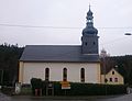
church

Mill monument

pond

Memorial stone 550 years of stilt village


Individual evidence
- ^ Wolfgang Kahl : First mention of Thuringian towns and villages. A manual. Verlag Rockstuhl, Bad Langensalza, 2010, ISBN 978-3-86777-202-0 , p. 274
- ^ Günter Steiniger: Mühlen im Weidatal Verlag Rockstuhl, Bad Langensalza, 2010, ISBN 978-3-934748-59-0 , pp. 74–79
Web links
Arnsgrün-Bernsgrün-Pöllwitz with Arnsgrün , Bernsgrün , Büna , Dobia , Frotschau , Pöllwitz , Schönbrunn and Wolfshain | Dörtendorf | Förthen | Kleinwolschendorf | Läwitz | Leitlitz | Mehla | Merkendorf with Piesigitz | Niederböhmersdorf | Pahren | Silberfeld with Quingenberg | Stilt village | Drive | Weckersdorf | Zadelsdorf | Zeulenroda