Amarna
| Amarna in hieroglyphics | |||||
|---|---|---|---|---|---|
Achet-Aton 3ḫ.t-Jtn horizon of the Aton |
|||||
| North palace | |||||
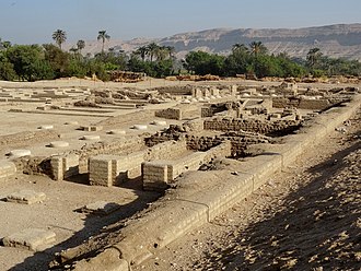
Tell el-Amarna , also just Amarna for short , is an archaeological site on the east bank of the Nile in Middle Egypt , in the governorate of al-Minya . It is located about 312 kilometers south of Cairo .
In Egyptological research, Amarna is usually used to describe the ruins of the former ancient Egyptian capital of King Akhenaten , Achet-Aton , which was in the former 15th Upper Egyptian district (" Hasengau ").
The place is named for a period of the late 18th Dynasty , which is known as the Amarna period .
etymology
The term Tell el-Amarna was coined by European travelers in the 19th century. It is made up of the name of the modern settlement "et-Till" and either the name "Beni Amran" (former Arab tribe) or "al-Amaria", another village in the area. In contrast, the term has nothing to do with Tell , the Arabic name for a settlement hill, since there is no such hill in this area.
The ancient name of the place was Achetaton ("Horizon of Aton"), whereby the actual city probably bore the name of the main temple Per Aton ("House of Aton").
Research history
The ruins of Achetaton were already visited by the French expedition under Napoleon Bonaparte , but the scientific research did not begin until John Gardner Wilkinson , who discovered the rock tombs on the east side of the city in 1824 . Karl Richard Lepsius , who visited the place for a short time on his expedition to Nubia , made some drawings and plaster casts in 1843.
After a fellachin discovered clay tablets with cuneiform letters in 1887 , which were part of the correspondence between the Egyptian royal court and princes from the Far East, the first systematic excavations of the Egypt Exploration Fund (EEF, renamed the Egypt Exploration Society in 1919) began in the winter of 1891/1892 directed by Flinders Petrie . Petrie found more clay tablets and the "State Archives" near the royal residence. From 1901 to 1907 Norman de Garis Davies copied the inscriptions on the rock tombs and texts on all border steles for the EEF.
Tell el-Amarna was also one of the research and excavation priorities of the German Orient Society (DOG) from 1911 to 1914 under Ludwig Borchardt . On December 6, 1912, he found, among other things, the famous Nefertiti bust in the workshop of the sculptor Thutmosis , which has been on view again in the Neues Museum Berlin since 2009 .
From 1921 to 1936 the Egypt Exploration Society (EES) undertook extensive work in the city area and examined, among other things, the royal tomb of Akhenaten.
Blocks of many buildings were discovered as reused building material in Karnak in the 1920s and in 1939 by a German expedition led by Günther Roeder in Hermopolis .
The EES resumed its work in 1977 under the direction of Barry Kemp ( University of Cambridge , UK). Since 1980, in cooperation with the Egyptian Antiquities Authority, she has been increasingly involved in the restoration and reconstruction of the city.
founding
King ( Pharaoh ) Akhenaten (Amenophis IV.) Founded the new capital Akhet-Aton in honor of Aten or for this god at this place. Akhenaten determined the size of the city through a total of 15 so-called "border steles", which he had erected on the east and west banks of the Nile in his fifth, sixth and eighth year of reign. According to the inscriptions on a border stele dating from the 5th year of his reign, this was the place “of creation that he (the king) prepared for him (the god)”. Due to the use of standardized stone blocks, the so-called talatat , the construction of the city took about three years.
Actually, Achetaton was not a capital in the modern sense like Memphis or Thebes , but essentially a royal residence and religious center. It is more with Tjehen-Aton ("Shine of Aton"), the new city foundation by Amenophis III. comparable in western lifts . Both had an official central district called Per Hai ("House of Jubilation") with temples and palaces in which royal memorials ( Heb-Sed ) were held, and other special buildings, such as the complexes Maru-Amun and Maru Aton .
Plant of the city
buildings
The border steles carved into the rock of the desert show the king, the queen and some of the daughters. The inscriptions tell of the founding of the city. In addition to the steles, statues of the ruling family were also carved into the rock. Most of the public buildings were in the center of the city. Above all, the Aton Temple is to be mentioned here, the walls of which took up an area of 730 by 229 meters. A smaller Aton temple may be a temple for the Aton cult, but also for the cult of the ruler. In the center of the city there were also palace complexes consisting of various courtyards and halls. From here the whole country was ruled. So it is not surprising that an almost intact diplomatic archive was found in the form of cuneiform - clay tablets , the so-called Amarna letters .
Most of the palaces were once richly decorated with statues and paintings , as well as glass and ceramic faiences inlaid in the walls . The actual residential areas were to the north and south of the city center. In the far south stood a facility known as the Maru-Aton of unknown function. Another district was located in the far north. Strong walls could be observed here, but this part of the city is poorly preserved. It was assumed that this was the actual residential palace of Akhenaten. A workers' settlement, probably for the construction of tombs, was found in the east, about two kilometers in the desert, from the actual city.
art

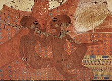
The artists of Amarna led painting, sculpture and relief art to an unprecedented bloom, with extremely lively, sometimes caricaturing , scenes from everyday life and a human representation of the royal couple Akhenaten and Nefertiti , which in contrast to the solidified abstract and typified archaic art Egypt stood. The art of this time is therefore also referred to as " Amarna art ".
Rock tombs
→ Main article: List of Amarna rock tombs
In the eastern mountains lies the Amarna necropolis , which is divided into a north cemetery (grave numbers 1 to 6), the south cemetery (grave numbers 7 to 25) and the royal wadi , with the royal grave and four other so-called secondary graves (graves 27 to 30), structured. Except for the side graves in Königswadi, all graves could be assigned by name. The northern and southern tombs are all private graves, with those buried in the northern cemetery serving as the king's advisers and those in the southern tombs being part of the executive in Akhenaten's reign.
A large number of decorations in the form of paintings or reliefs have been preserved in some of these tombs. Today they give researchers a deep insight into the living habits of the inhabitants of the former city of Achet-Aton, the Aton cult, the royal family and the nature of their reign. The official graves were discovered by Alessandro Barsanti in December 1891 . The only surviving version of the so-called Aton hymn , also known as the sun song or sun hymus, is found in the grave of Eje ( No. 25 ) , which in 13 columns fills almost the entire area of the right wall in the entrance corridor.
After Akhenaten's reign
The city only existed for a short time. After Akhenaten's death, the court moved to the old capital, Memphis, under King Tutankhamun , and Akhet-aton was never again colonized on a large scale. There are indications that the temple was used until the time of Horemheb , possibly until Seti I maintained was.
Later pharaohs destroyed much of Akhenaten's work to erase the memory of him. Many buildings were demolished at the time of Ramses II and the material was reused for various nationwide construction projects. Talatat blocks from Achet-Aton were found mainly in Antinoupolis and in the temples of Hermopolis, on the other bank of the river, where they were used as filling material, but also in Karnak, several hundred kilometers away.
Graves of the 22nd and 23rd dynasties in the workers' village to the southeast indicate a weak repopulation phase in the late Pharaonic period. The Romans built houses and a large cemetery in the northern suburb, and a fortress followed in the late Roman period . Christian traces can be found in grave no. 6 , which was used for a church.
See also
literature
- Kathryn A. Bard (Ed.): Encyclopedia of the Archeology of Ancient Egypt. Routledge, London 1999, ISBN 0-415-18589-0 , pp. 763-776.
- Barry Kemp : The City of Akhenaten and Nefertiti: Amarna and its People. First paperback Edition, Thames & Hudson, London 2013, ISBN 978-0-500-29120-7 .
- Barry Kemp, Salvatore Garfi: A survey of the ancient city of El-'Amarna. (= Occasional publications. Vol. 9). Egypt Exploration Society, London 1993, ISBN 978-0-85698-122-7 .
- William J. Murnane, Charles Cornell Van Siclen: The boundary stelae of Akhenaten (= Studies in Egyptology. ). Kegan Paul International, London / New York 1993, ISBN 0-7103-0464-1
- JDS Pendlebury : Tell el-Amarna. Dickson & Thompson, London 1935.
- WM Flinders Petrie : Tell El Amarna. Methuen & Co, London 1894.
- Herbert Ricke: The floor plan of the Amarna house. With 26 plates and 60. Fig. In the text (= excavations of the German Orient Society in Tell-el-Amarna. Vol. 4; Scientific publication. Vol. 56). Leipzig 1932.
- Heinrich Schäfer : Amarna in religion and art. In: Mission of the German Orient Society. No. 7, Henrichs, Leipzig 1931.
- Christian Tietze (Ed.): Amarna. Living spaces - images of life - images of the world (= exhibition catalog Cologne 2008 ). 2nd, updated and expanded edition, Arcus-Verlag, Weimar 2010, ISBN 978-3-00-031582-4 .
- Publications on Amarna in the catalog of the German National Library
Web links
- Amarna Project (website of the University of Cambridge) (English)
- amarna3d.com (3D reconstructions) (English)
- Search for Amarna in the German Digital Library
- Search for Amarna in the SPK digital portal of the Prussian Cultural Heritage Foundation
Individual evidence
- ↑ a b c d Eric P. Uphill: Tell el-Amarna, city . In: Kathryn A. Bard (Ed.): Encyclopedia of the Archeology of Ancient Egypt. Routledge, London 1999, ISBN 0-415-18589-0 , p. 763.
- ↑ B. Kemp in: Wolfgang Helck , Eberhard Otto , Wolfhart Westendorf : Lexikon der Ägyptologie. (LÄ) Volume VI, Harrassowitz, Wiesbaden 2000, ISBN 3-447-04468-3 , column 309ff.
- ↑ Gabriele Höber-Kamel: On the history of the Amarna period. In: Nefertiti. Kemet issue 3, 2010, p. 4.
- ↑ Christian Tietze (ed.): Amarna. Living spaces - life images - world views. Weimar 2010, p. 36.
- ↑ a b c d Christian Tietze (Ed.): Amarna. Living spaces - life images - world views. Weimar 2010, p. 37.
- ↑ Nicholas Reeves: Akhenaten. Egypt's false prophet (= cultural history of the ancient world. Vol. 91). von Zabern, Mainz 2002, ISBN 3-8053-2828-1 , p. 182.
- ^ Hermann A. Schlögl: Akhenaten - Tutankhamum. Data, facts, literature. 5th, extended edition, Harrassowitz, Wiesbaden 2013, ISBN 978-3-447-06845-1 , p. 102.
- ↑ a b c d Eric P. Uphill: Tell el-Amarna, city . In: Kathryn A. Bard (Ed.): Encyclopedia of the Archeology of Ancient Egypt. Routledge, London 1999, ISBN 0-415-18589-0 , p. 764.
Coordinates: 27 ° 39 ′ 42 ″ N , 30 ° 54 ′ 20 ″ E


