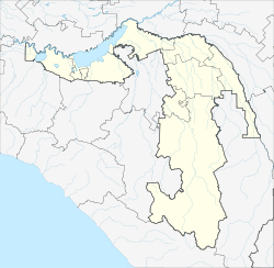
Tulski (Adygeja)
| settlement
Tulski
Тульский
|
||||||||||||||||||||||||||||||||||
|
||||||||||||||||||||||||||||||||||
|
||||||||||||||||||||||||||||||||||
| List of large settlements in Russia | ||||||||||||||||||||||||||||||||||
Tulski ( Russian Тульский ) is a rural settlement in the Republic of Adygeja ( Russia ) with 10,732 inhabitants (as of October 14, 2010).
geography
The place is on the northern edge of the Greater Caucasus , a good ten kilometers south of the center of the republic capital Maikop , on the right bank of the Kuban tributary Belaya . In the surrounding area, the wooded foothills of the Caucasus rise to a height of over 500 m .
Tulski is the administrative center of the Rajons Maikopski . The municipality (gorodskoje posselenije) Tulski also includes the village Machoschepoljana, 12 kilometers southeast in the mountains.
history
The place was created in the final phase of the Caucasus War 1817–1864 as part of the settlement of Russians on the area previously populated by Circassians in 1862 as Stanitsa Jegeruchajewskaja. As early as 1867, the Stanitsa was given the name Tulskaja in honor of the first settlers, volunteers of the Tula Infantry Regiment (Russian Tulski pechotny polk ).
During the Soviet period, Stanitsa became the administrative seat of the Maikop Raion, which had existed since 1924, on April 10, 1936, after the city of Maikop and the northern part of the Raion around the Stanitsa Chanskaya from what was then the Azov-Black Sea Region had been transferred to the Adygea Autonomous Oblast . With the establishment of the Krasnodar Territory on September 13, 1937, the Rajon came to this and received the name of its administrative seat Tulskaya.
During the Second World War , Tulskaja was occupied by the German Wehrmacht from August 1942 to January 1943 .
On April 28, 1962, the district was dissolved and its territory attached to the Maikop district of the Adygea Autonomous Oblast. In 1963 Stanitsa Tulskaya was given the status of an urban-type settlement in its current name. After several administrative changes from 1962 onwards, Tulski became the center of the Rajon again on July 6, 1965. Tulski has been a rural settlement (possjolok) since 2011 .
Population development
| year | Residents |
|---|---|
| 1939 | 3,299 |
| 1959 | 4,706 |
| 1970 | 7,077 |
| 1979 | 8,024 |
| 1989 | 9,538 |
| 2002 | 10,502 |
| 2010 | 10,732 |
Note: census data
Culture and sights
A local history museum has existed in Tulski since 1952 and has been open to the public since 1993.
Economy and Infrastructure
In Tulski there are companies in the forestry, construction and food industries.
Two kilometers west of the settlement, on the other bank of the Belaya, is the Tulskaya station on the single-track railway line Beloreschenskaya - Maikop - Hadschoch ( Kamennomostsky ). The road that opens up the southern part of the Republic of Adygea and starts from Maikop, where there is a connection to the Armavir - Tuapse branch of the M29 trunk road, runs through the valley of the Belaja via Tulski (western bypass) .
Individual evidence
- ↑ a b Itogi Vserossijskoj perepisi naselenija 2010 goda. Tom 1. Čislennostʹ i razmeščenie naselenija (Results of the All-Russian Census 2010. Volume 1. Number and distribution of the population). Tables 5 , pp. 12-209; 11 , pp. 312–979 (download from the website of the Federal Service for State Statistics of the Russian Federation)
- ↑ a b Tulski on the website of the Geographical Institute of the RAN (Russian)
- ↑ Osnovnye administrativno-territorial ʹ nye preobrazovanija na Kubani (1793–1985 gg.) . Krasnodarskoe knižnoe izdatelʹstvo, Krasnodar 1986 ( The most important administrative-territorial transformations in the Kuban region 1793–1985 ; Russian).
- ↑ Information about the museum at museum.ru (Russian)


