Višnjan
|
Višnjan Visignano |
||
|
||
|
|
||
| Basic data | ||
|---|---|---|
| State : |
|
|
| County : |
|
|
| Height : | 244 m. i. J. | |
| Area : | 69 km² | |
| Residents : | 2,274 (2011) | |
| Population density : | 33 inhabitants per km² | |
| Telephone code : | (+385) 052 | |
| Postal code : | 52463 | |
| License plate : | PU | |
| Structure and administration (status: 2013, cf. ) |
||
| Community type : | local community | |
| Mayor : | Milan Dobrilović ( IDS / DDI ) | |
| Website : | ||
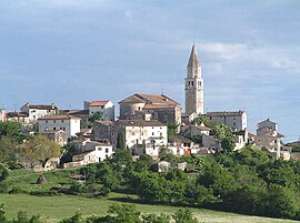
 View of Višnjan Visignano |
||
Višnjan ( Italian Visignano ) is a town and a municipality in the Istria County , Croatia . The number of inhabitants of the municipality in 2011 was 2,274, with 694 living in Višnjan itself.
According to the 2011 census, 70.01% of the population are Croatians, 6.82% Italian and 18.03% Istrians.
Villages in the municipality
|
|
|
|
|
|
|
|
|
|
|
|
geography
Višnjan is located 13 km east of Poreč near the Pula - Koper road .
history
Višnjan was first mentioned in a document in 1203. However, the place was already settled in Roman times . After the fall of the Roman Empire, the area fell to the Ostrogoths , later to Byzantium and then to the Lombards . From the time of the Romans to the Byzantines, Višnjan was under the administration of Poreč , from 1200 under Motovun . Like Motovun, Višnjan fell to Venice in 1278 , whose influence lasted until the fall of the Lion Republic in 1779. During this time, Višnjan was ruled by noble families from Motovun.
Višnjan has been protected by a city wall since the early Middle Ages. During the Uskok War in 1617 all buildings outside the city wall were razed by the Uskoks .
With the fall of Venice towards the end of the 18th century, the city fell for a short time under Napoleon's rule and in 1815 under the Austrian Empire , which became Austria-Hungary in 1867 ; in this it remained part of Cisleithania .
After the First World War and the collapse of the Danube Monarchy , Višnjan was part of Italy until the end of the Second World War . After the Second World War, Višnjan became part of the Republic of Yugoslavia in 1945 , namely the Republic of Croatia .
Attractions
The chapel of St. Anthony the Abbot (Crkva Sv. Antuna Opata) at the crossroads was built around 1500. The interior is decorated with frescoes and Glagolitic scripts. Above the age there is a painting by the master Dominik from Udine .
To get to the main square, you first pass the Vrata Serenissima city gate, which was undeveloped in the 17th and 18th centuries . However, the lion of St. Mark above the gate in Sein dates from 1517.
In the town square, just a few meters above the town gate, there is the town loggia (from the 17th / 18th century) and a fountain from 1842. The parish church of St. Quiricus and Julitta (Župna crkva Sv . Kvirika i Julite) with the 27 meter high bell tower from 1753.
Višnjan is also known for the observatory west of the historic old town .
sons and daughters of the town
- Antun Korlević (1851–1915), Croatian entomologist
- Korado Korlević , Croatian astronomer
Web links
- Višnjan webcam
- Istrian from Smrikve Description Visnjan (English)
Individual evidence
- ^ Croatian Bureau of Statistics: Census 2011 Population Census 2011


