Waikato River
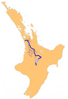
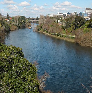
The Waikato River is the longest river in New Zealand . It is located in the center of the North Island - mostly in the Waikato region - and is a total of 425 kilometers long.
Origin of name
The term Waikato is Māori and means "flowing water".
geography
The origin of the river extends far up into the Central Volcanic Plateau of New Zealand's North Island. The river, often still referred to as the Tongariro River in this area , arises from the confluence of various sources on the slopes of the 2797 m high Ruapehu . Further north, the Waikato River flows into Lake Taupo , the largest lake in the Pacific state. On the northeastern bank near the city of Taupo , the river, now known exclusively as the Waikato River , forms the outlet of Lake Taupo . After the spectacular Huka Falls , the river orients itself to the northwest, where it leaves the mountainous terrain for the first time and is flanked by the extensive, almost entirely agricultural Waikato Plains . In this extremely fertile plain there are numerous smaller settlements and the city of Hamilton with around 141,000 inhabitants.
Between Taupo and Hamilton , the river serves as a water reservoir and to generate electricity through the eight reservoirs Lake Aratiatia , Lake Ohakuri , Lake Atiamuri , Lake Whakamaru , Lake Maraetai , Lake Waipapa , Lake Arapuni , Lake Karapiro . After a total of 425 kilometers, the Waikato River flows into the Tasman Sea at Port Waikato . The river from Port Waikato to Hamilton is navigable .
The Waikato River has with 14,456 km 2 on all rivers in New Zealand's second-largest watershed.
history
The area around the river was already cultivated and used for agriculture by the Māori . The Iwi Tainui in particular settled in the plain along the course of the river. During the New Zealand Wars , the Waikato River was the site of some skirmishes between Native Americans and British soldiers between 1863 and 1865. Even today, the Waikato area and the area south of the river, known as King Country , are among the regions with the most Māori . The Tainui tribe filed a petition with the Waitangi Tribunal for sovereignty over all banks of the river. The Māori royal movement from the 1850s originated in the region. The official representative of the Māori , Tuheitia Paki (previously: Te Atairangikaahu ) since August 2006, still resides in the Turangawaewae - Marae in Ngaruawahia .
Flora Fauna
flora
Before the arrival of humans, the area around the river was largely made up of freshwater wetlands overgrown with native plants. Of the 110,000 hectares in the entire region in 1840 , only 30,000 hectares are still marshland. The massive shrinking of the habitat for aquatic and bog plants is only a problem of the endemic flora. The other is the introduction of non-native plants. An example related to the Waikato River is alligator weed , a subspecies of the parrot leaf (from the Amaranthaceae family) that is one of the most aggressive pest plants on earth.
fauna
The length of the Waikato River is home to at least 19 different native and 10 introduced species of fish, as well as a variety of invertebrates . One has to distinguish the species in the river itself from those in the reservoirs. Examples of native fish are numerous species of galaxies , river eels (especially New Zealand eels ) and various types of sleeper gobies .
Todays situation
meaning
The Waikato River is not only of great historical, cultural and ecological importance for New Zealand, but is also important in terms of infrastructure and as a recreational area. There are a total of eight hydropower plants along the river , which supply a large part of the North Island with electricity. With an annual production of 4,000 gigawatt hours , these power plants cover 13% of the country's electricity consumption. This also creates eight reservoirs , which are a popular recreational area. The Waikato River also provides drinking water for over 140,000 people.
Water quality
The water quality of the Waikato River is severely impaired by the sometimes only slightly treated sewage from large cities and more than ten large factories. Also located in Huntly which is operated with coal and natural gas power station Huntly , largest with stand 2014 New Zealand power plant, with an installed capacity of 1.2 GW . At the moment (2006) only the water of the river is used for cooling. Strict regulations regarding the maximum temperature of the water to protect the wildlife in the river meant that the power plant could often not run at maximum output on hot days. A new cooling tower should help. Other problems affecting the river include agricultural pollution, the threat to shipping from soil erosion and the plan to pump large quantities of water from the river into the metropolis of Auckland .
Web links
- The health of the Waikato River and catchment . (PDF; 688 kB)Information for the Guardians Establishment Committee. Waikato Regional Council, March 2008,accessed January 3, 2020.
- waikato River - Photos . In: Virtual New Zealand . David Johnsons,accessed January 3, 2020.
Individual evidence
- ↑ a b Waikato River . In: NZ Topo Map . Gavin Harriss , accessed January 3, 2020 .
- ↑ Coordinates and longitudes were determined using Goggle Earth Pro Version 7.3.2.5776 on January 3, 2020
- ↑ a b c The health of the Waikato River and catchment . (PDF; 688 kB) Information for the Guardians Establishment Committee . Waikato Regional Council , March 2008, p. 8 , accessed January 3, 2020 .
- ↑ 2013 Census QuickStats about a place : Hamilton City - Population and dwellings . Statistics New Zealand , accessed July 6, 2016 .
- ↑ Topo maps . Land Information New Zealand , accessed January 3, 2020 .

