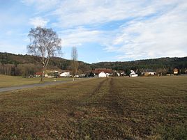
Wangen (Mulhouse)
|
Cheeks
community Muehlhausen
Coordinates: 49 ° 11 ′ 30 ″ N , 11 ° 28 ′ 10 ″ E
|
|
|---|---|
| Height : | 440 m above sea level NHN |
| Residents : | 89 (2012) |
| Postal code : | 92360 |
| Area code : | 09185 |
|
Cheeks
|
|
Wangen is a district of the municipality of Mühlhausen in the Upper Palatinate district of Neumarkt in the Upper Palatinate .
location
Wangen lies at the foot of the Upper Palatinate Jura at 440 m above sea level. NHN east of the Ludwig-Danube-Main Canal .
history
When in 1376 the Reichsministerial Stein donated the little monastery "Zum Heiligen Grab" on Schlüpfelberg , not far from Sulzbürg , to a certain extent as a subsidiary monastery of the Benedictine monastery Plankstetten , the founding estates included a house and a farmstead for the Lords of Stein in Wangen as well as half of the major and minor tenth to Wangen donated by Weickmann der Hofer. In 1528, Emperor Karl V awarded the Wolfsteiners “alle Fraisch ” to Wappersdorf , Weaersdorf (= Weihersdorf ) and Wangen, after the ducal mayor of Neumarkt had “unfairly” claimed this right. Wangen therefore belonged to the Wolfsteiners and to their Sulzburger office. Around 1732 six courtyards with the shepherd's house formed the village. When the Wolfsteiner died out in 1740, the Bavarian elector acquired their property, including Wangen, which at that time consisted of five subjects (courts). Originally a parish of Tauernfeld , Wangen was parish with Greißelbach in the parish of Döllwang in 1628, soon after the Counter-Reformation , when the parish of Tauernfeld was dissolved .
At the end of the Old Kingdom , around 1800, Wangen consisted of five farms from two landowners: The Lower Hofmark Berngau owned the three farms Großhauser, Schmid, Röckl and another smaller farm, the Freystadt Spital, the largest farm whose owner was also called Röckl. The courts were subject to the ducal Bavarian mayor's office in Neumarkt.
In the new Kingdom of Bavaria (1806), the Döllwang tax district was formed around 1810 , to which Wangen was assigned and to which Greißelbach , Weihersdorf and Wappersdorf also belonged. With the municipal edict of 1818, the rural community of Döllwang was created, which only included Döllwang, Greißelbach and Wangen. Immediately before the regional reform in Bavaria , the municipality of Döllwang consisted only of Döllwang itself and the new settlement Hacklsberg ; At that time, Wangen was one of nine districts in the municipality of Wappersdorf. This was incorporated into Mühlhausen on January 1, 1974. Since then, Wangen has been one of 24 officially named parts of the municipality in Mühlhausen.
Not far from the village there is a remarkable wayside cross .
Population numbers
- 1830: 70 (10 houses)
- 1836: 78 (12 houses)
- 1875: 75 (25 buildings; cattle: 2 horses, 77 cattle)
- 1900: 59 (12 residential buildings)
- 1937: 61
- 1961: 62 (14 residential buildings)
- 1978: 89
- 1987: 81 (22 residential buildings, 22 apartments)
- 2012: 89
Transport links
The place can be reached from the north via a junction from the state road 2220 in Greißelbach and from the south via a junction from the federal road 299 in Mühlhausen or at the height of Wappersdorf, the closest place.
literature
- Repertory of the topographical atlas sheet. Neumarkt , 1836
- Franz Xaver Buchner : The diocese of Eichstätt. Volume I, Eichstätt 1937
- Bernhard Heinloth: Historical Atlas of Bavaria. Part Altbayern, Issue 16: Neumarkt , Munich: Commission for Bavarian State History, 1967
Individual evidence
- ↑ Heinloth, p. 168; Atlas sheet Neumarkt, p. 107
- ↑ Heinloth. P. 102
- ↑ Summary designation of the Gräfl. Wolffstein Imperial Fiefs and Allodial Goods , o. O., [after 1732], p. 114
- ↑ Heinloth, p. 108
- ↑ Buchner I, p. 182
- ↑ Heinloth, p. 286
- ↑ Heinloth, p. 322
- ↑ Heinloth, pp. 322, 330
- ^ Joseph Anton Eisenmann and Carl Friedrich Hohn: Topo-geographical-statistical lexicon of the Kingdom of Bavaria, 2nd volume , Erlangen 1832, p. 985
- ↑ Popp, Th. D. (ed.): Matrikel des Bissthumes Eichstätt , Eichstätt: Ph. Brönner, 1836, p. 52
- ↑ Kgl. Statistical Bureau (ed.): Complete list of localities of the Kingdom of Bavaria. According to districts, administrative districts, court districts and municipalities, including parish, school and post office affiliation ... with an alphabetical general register containing the population according to the results of the census of December 1, 1875 . Adolf Ackermann, Munich 1877, 2nd section (population figures from 1871, cattle figures from 1873), Sp. 881 , urn : nbn: de: bvb: 12-bsb00052489-4 ( digitized version ).
- ↑ K. Bayer. Statistical Bureau (Ed.): Directory of localities of the Kingdom of Bavaria, with alphabetical register of places . LXV. Issue of the contributions to the statistics of the Kingdom of Bavaria. Munich 1904, Section II, Sp. 865 ( digitized version ).
- ↑ Buchner I, p. 184
- ↑ Bavarian State Statistical Office (ed.): Official city directory for Bavaria, territorial status on October 1, 1964 with statistical information from the 1961 census . Issue 260 of the articles on Bavaria's statistics. Munich 1964, DNB 453660959 , Section II, Sp. 554 ( digitized version ).
- ↑ Bavarian State Statistical Office (ed.): Official place directory for Bavaria, territorial status: May 1, 1978 . Issue 380 of the articles on Bavaria's statistics. Munich December 1978, DNB 790598426 , p. 122 ( digitized version ).
- ↑ Bavarian State Office for Statistics and Data Processing (Ed.): Official local directory for Bavaria, territorial status: May 25, 1987 . Issue 450 of the articles on Bavaria's statistics. Munich November 1991, DNB 94240937X , p. 259 ( digitized version ).
- ↑ Müller's Großes Deutsches Ortsbuch 2012 , Berlin / Boston 2012, p. 1464


