Bachhausen (Mulhouse)
|
Bachhausen
community Muehlhausen
Coordinates: 49 ° 9 ′ 28 " N , 11 ° 24 ′ 58" E
|
|
|---|---|
| Height : | 401 m above sea level NHN |
| Residents : | 102 (2012) |
| Incorporation : | July 1, 1972 |
| Postal code : | 92360 |
| Area code : | 09185 |
|
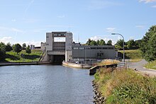
Bachhausen on the Main-Danube Canal
|
|
Bachhausen is a district of the municipality Mühlhausen in the Upper Palatinate district of Neumarkt in the Upper Palatinate and a former municipality.
location
The village is located south of Sulzbürg and south of the Main-Danube Canal at around 401 m above sea level. NHN . To the south of the village, the Roßbach flows past in an easterly direction and is absorbed by the canal.
history
Around 1140 Otto von Bachhausen made a donation to the Weltenburg monastery , including the interest from a meadow in Bachhausen. Shortly before 1220, Knight Ramung von Schwabach wanted to establish the parish of Bachhausen through a foundation, but in 1224 Bishop Friedrich von Eichstätt spoke of the chapel of the Weidenwang parish in Bachhausen , where the Eichstatter Bishop Gundekar II had consecrated a church between 1057 and 1075, as a branch to. When the monastery Grab was founded in 1376 by the Lords of Stein am Schlüpfelberg as a kind of branch monastery of the Benedictine monastery in Plankstetten , the foundation goods from the Steiner's own goods also included goods in Bachhausen.
In the 14th century, Bachhausen was part of the Wolfstein Castle of Niedersulzbürg . Albrecht von Wolfstein had bought the church set in 1359 from the Waldsachsen monastery, and in 1361 Hilpolt III, who was seated on Niedersulzbürg, had it. von Stein acquired goods in Bachhausen from the Poor Clare Monastery of St. Clare in Nuremberg .
At the Augsburg Reichstag in 1530, the Wolfsteiners were present among the Protestant aristocrats, so they had accepted the Reformation . However, it was not until the middle of the 16th century that they had implemented this in their territory; in the parish of Bachhausen, part of the Hilpoltstein deanery of the Eichstätt diocese , the Reformation only came into effect around 1578. The Counter-Reformation that began in 1625 under the Bavarian Elector Maximilian had to stop at the state sovereignty of the Wolfsteiners, so Bachhausen, which had become Protestant, remained Protestant. With the Reformation, the services in the "Grabkirchlein" ceased, but the Bachhauser pastor had to give a sermon there three times a year at Sulzburger's behest.
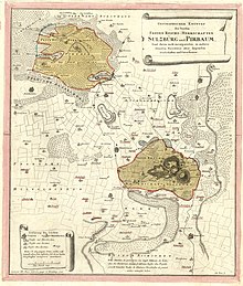
Around 1732, the place "Bachhaußen", consisting of 15 "teams" (= courtyards) and the shepherd's house, belonged to the Wolfstein office in Sulzbürg. 1740 died out with the last Count of Wolfstein, Christian Albrecht, the family; the property came as a settled imperial fief (1769 also the allodial property ) to the ducal Bavaria, which set up the Sulzbürg-Pyrbaum cabinet rule for the administration of these goods, including the goods of the village of Bachhausen , with Bachhausen having 16 courtyards, both high and low court Sulzbuerg the two courtyards of the Kösterlein grave were subordinate to the Wolfsteiners and the monastery Plankstetten alternately. At the end of the Old Kingdom , around 1800, the place made up 17 courtyards, namely three half courtyards, one third courtyard, five quarter courtyards and eight 1/16 courtyards.
In the new Kingdom of Bavaria (1806) Bachhausen was assigned to the Erasbach tax district , which was formed around 1808 . With the community edict of 1818, the rural community of Bachhausen was formed from Bachhausen and Körnersdorf in the district court of Neumarkt in the Upper Palatinate , which came to the district court and rent office of Beilngries in 1827 and to which the rice mill from the community of Erasbach and Wiesenheid from the community of Pollanten were added in 1830 ; Wiesenheid can be traced for the last time in 1856 and has since disappeared. The Patrimonial Court II. Class of the Hofmark Erasbach of Baron von Rupprecht, which existed from 1820 to 1831, had four estates in Bachhausen. As part of the regional reform in Bavaria , the municipality of Bachhausen was incorporated from the dissolved Upper Palatinate district of Beilngries on July 1, 1972, to Mühlhausen in the Upper Palatinate district of Neumarkt.
Population of the church village
- 1830: 148 (23 houses)
- 1867: 128 (57 buildings, 1 church, school)
- 1875: 132 (77 buildings; cattle: 8 horses, 134 cattle)
- 1900: 125 (27 residential buildings)
- 1938: 104 (9 Catholics in the parish Sulzbürg, 95 Protestants)
- 1950: 159 (24 houses)
- 1961: 117 (22 residential buildings)
- 1978: 102
- 1987: 106 (25 residential buildings, 29 apartments)
- 2012: 102
Population of the municipality of Bachhausen
- 1867: 229 (81 buildings in 3 locations, namely Bachhausen, Körnersdorf and Reismühle)
- 1875: 218 (4 Catholics, 214 Protestants) (130 buildings, 44 residential buildings) (livestock: 20 horses, 253 head of cattle, 228 sheep, 138 pigs)
- 1900: 209 (11 Catholics, 198 Protestants) (457 hectares) (45 residential buildings) (livestock: 14 horses, 247 head of cattle, 132 sheep, 185 pigs, 1 goat)
- 1961: 185 (26 residential buildings) (457 hectares)
Evangelical Petruskirche
It is not known when the first church was built. Before the Reformation, Bachhausen was a subsidiary of Weidenwang. In 1584, Johann Zinß, a brother of the pastor of Kerkhofen , was the first Protestant pastor to work in Bachhausen. In 1681 the church got a new altar; the pulpit is placed above him. In 1736, a new building was built including the Gothic east tower; the quarry stone cemetery wall with a gate entrance dates from the 17th century.
The evangelical pastor of Bachhausen also had to pastorate Mühlhausen.
Personalities
- Schweigger, Johann Georg , goldsmith, gold and silver worker, * in Bachhausen, buried in Nuremberg in 1679
Architectural monuments
In addition to the church, the parsonage from the beginning of the 19th century and house no. 21, a residential stable with plaster tapes, in the 18th / 19th century. Erected in the 16th century as a monument.
See also list of architectural monuments in Mühlhausen (Upper Palatinate) #Bachhausen
Transport links
A communal road leads from the state road 2220 to Bachhausen and on over the canal to the NM 19 district road. There are also roads from Erasbach and Körnersdorf to Bachhausen. One kilometer southeast of Bachhausen is the Bachhausen lock of the Main-Danube Canal.
literature
- Bernhard Heinloth: Historical Atlas of Bavaria. Part Altbayern, Issue 16: Neumarkt , Munich: Commission for Bavarian State History, 1967
- Gerhard Hirschmann: Historical Atlas of Bavaria. Part of Franconia. Row I, Issue 6. Eichstätt. Beilngries - Eichstätt - Greding, Munich 1959
- Franz Xaver Buchner : The diocese of Eichstätt. Volume II, Eichstätt 1938
Individual evidence
- ^ Negotiations of the historical association of Upper Palatinate and Regensburg , 20th volume and 12th volume of the new series, Regensburg: J. Keitmayr, 1861, p. 85 f.
- ↑ Buchner II, p. 730
- ↑ Heinloth, p. 167
- ↑ Summary designation of the Gräfl. Wolffstein Imperial Fiefs and Allodial Goods , o. O., [after 1732], p. 12
- ^ CH von Lang: Regesta sive rerum boicarum autographa… , Volume IX, Munich 1841, p. 38 f.
- ↑ Buchner II, p. 823
- ↑ 16th annual report of the Historical Association in Middle Franconia , Ansbach 1847, p. 63
- ↑ Summary designation of the Gräfl. Wolffstein Imperial Fiefs and Allodial Goods , o. O., [after 1732], p. 113
- ↑ Heinloth, p. 106
- ↑ Heinloth, p. 255
- ↑ Hirschmann, p. 211
- ↑ Heinloth, p. 180 f.
- ^ Karl Friedrich Hohn: The rain district of the Kingdom of Bavaria, described geographically and statistically , Stuttgart and Tübingen: Cotta, 1830, p. 136
- ↑ Joseph Heyberger: Topographical-statistical manual of the Kingdom of Bavaria with an alphabetical local dictionary , Munich 1867, Sp. 992
- ↑ a b Kgl. Statistical Bureau (ed.): Complete list of localities of the Kingdom of Bavaria. According to districts, administrative districts, court districts and municipalities, including parish, school and post office affiliation ... with an alphabetical general register containing the population according to the results of the census of December 1, 1875 . Adolf Ackermann, Munich 1877, 2nd section (population figures from 1871, cattle figures from 1873), Sp. 1156 , urn : nbn: de: bvb: 12-bsb00052489-4 ( digitized version ).
- ↑ a b K. Bayer. Statistical Bureau (Ed.): Directory of localities of the Kingdom of Bavaria, with alphabetical register of places . LXV. Issue of the contributions to the statistics of the Kingdom of Bavaria. Munich 1904, Section II, Sp. 807 ( digitized version ).
- ↑ Buchner II, p. 571
- ↑ Hirschmann, p. 211
- ↑ a b Bavarian State Statistical Office (ed.): Official city directory for Bavaria, territorial status on October 1, 1964 with statistical information from the 1961 census . Issue 260 of the articles on Bavaria's statistics. Munich 1964, DNB 453660959 , Section II, Sp. 517 ( digitized version ).
- ↑ Bavarian State Statistical Office (ed.): Official place directory for Bavaria, territorial status: May 1, 1978 . Issue 380 of the articles on Bavaria's statistics. Munich December 1978, DNB 790598426 , p. 122 ( digitized version ).
- ↑ Bavarian State Office for Statistics and Data Processing (Ed.): Official local directory for Bavaria, territorial status: May 25, 1987 . Issue 450 of the articles on Bavaria's statistics. Munich November 1991, DNB 94240937X , p. 259 ( digitized version ).
- ↑ Müller's Großes Deutsches Ortsbuch 2012 , Berlin / Boston 2012, p. 84
- ↑ Heyberger, Col. 992
- ^ Johann Heinrich von Falckenstein: Analecta Nordgaviensia , I. Gleanings , Schwabach: Christian Hannibal Steinmarck, 1734, p. 68 f.
- ^ Sixtus Lampl and Otto Braasch: Monuments in Bavaria, Volume III: Upper Palatinate. Ensembles, architectural monuments, archaeological site monuments, Munich: R. Oldenbourg Verlag, 1986, p. 153
- ^ Nürnberger Künstlerlexikon , Volume 1, AG, Munich: KG Saur, 2007, p. 1412
- ↑ Lampl / Braasch, p. 153


