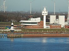
Hamburg Waterways and Shipping Office
|
Hamburg Waterways and Shipping Office |
|
|---|---|
| State level | Federation |
| position | Local authority |
| Supervisory authority | Directorate-General for Waterways and Shipping |
| founding | 1949 |
| Headquarters | Hamburg-Rotherbaum |
| Authority management | Bernhard Meyer (acting) |
| Web presence | wsa-hh.wsv.de |
The Waterways and Shipping Office Hamburg (WSA Hamburg) is a waterways and shipping office in Germany. It belongs to the service area of the General Directorate for Waterways and Shipping , formerly Waterways and Shipping Directorate North .
Area of responsibility
The Hamburg Waterways and Shipping Office is responsible for the Elbe federal waterway from the Hamburg port border to St. Margarethen a little above Brunsbüttel (border with the Cuxhaven Waterways and Shipping Office area ), the Hahnöfer Nebenelbe and the Este approach with the Mühlenberger Loch . In addition, the Hamburg Waterways and Shipping Office is responsible for parts of the tributaries Este, Lühe , Schwinge , Pinnau , Krückau and Stör , the Bützflether Süderelbe, the Ruthenstrom, the Wischhafener Süderelbe and the Freiburg harbor priel.
Area of responsibility
The tasks of the Hamburg Waterways and Shipping Office include:
- Maintenance and expansion of the Elbe federal waterway and its tributaries
- Maintenance and operation of the floating and fixed sea marks in the official area
- Order and safety of shipping and operation of the traffic control center in Brunsbüttel
- Takeover of electricity and shipping police tasks.
Outskirts
The outskirts of Glückstadt , Stade and Wedel as well as the building yard Wedel belong to the Hamburg Waterways and Shipping Office .
- The outskirts of Glückstadt are responsible for the rivers Pinnau to Pinneberg , Krückau to Elmshorn and Stör to Kellinghusen and all fixed navigation signs and other structures on the right bank of the Elbe (Schleswig-Holstein) between the pin lock and the lock island in Brunsbüttel.
- The suburb of Stade is responsible for the federal waterways Este to Buxtehude , Lühe to Horneburg and Schwinge to Stade, the Bützflether Süderelbe, the Ruthenstrom, the Wischhafener Süderelbe and the Freiburg harbor priel. In addition, the inner Estes barrier is located in the official area of the Stade suburb of the Hamburg Waterways and Shipping Office.
- The Wedel suburb is responsible for the Lower Elbe from the Hamburg port border to St. Margarethen.
- The Wedel building yard is responsible for maintenance and repair work on ships and navigation marks of the Hamburg Waterways and Shipping Office. The building yard has its own port with pier and pontoon systems as well as a slipway with which ships can be pulled out of the water and overtaken in the own shipbuilding hall.
Traffic control center
As a branch office, the Hamburg Waterways and Shipping Office maintains a traffic control center in Brunsbüttel , from which shipping traffic on the Lower Elbe and its tributaries between Brunsbüttel and the Hamburg border is monitored and controlled around the clock. For this purpose, the office operates a land radar chain consisting of six radar stations.
The traffic control center is integrated into the Elbe traffic safety system, which includes both the WSA Hamburg traffic control center and the WSA Cuxhaven traffic control center . The Brunsbüttel WSA Brunsbüttel traffic control center for the Kiel Canal is also located in Brunsbüttel .
Small vehicle license plate
The small watercraft in the area of the Hamburg Waterways and Shipping Office are assigned small vehicle registration numbers with the identifier HH .
See also
Web links
Individual evidence
- ↑ Verkehrszentrale Brunsbüttel , Waterways and Shipping Office Hamburg, accessed on July 9, 2018.
- ↑ Verkehrszentrale , Wasserstraßen- und Schifffahrtsamt Cuxhaven, accessed on July 9, 2018.
- ↑ We guarantee safety through traffic monitoring and traffic analysis, Brunsbüttel Waterways and Shipping Office, accessed on July 9, 2018.
Coordinates: 53 ° 33 ′ 51 ″ N , 9 ° 59 ′ 27 ″ E

