
Hamlet (Sinsheim)
|
hamlet
City of Sinsheim
|
|
|---|---|
_COA.svg) |
|
| Height : | 265 m |
| Residents : | 1971 (December 31, 2017) |
| Incorporation : | July 1, 1971 |
| Postal code : | 74889 |
| Area code : | 07261 |
 Location of Weiler in Sinsheim
|
|

Weiler is a village in the south of the Rhein-Neckar district that has belonged to Sinsheim since 1971 . The place is below Steinsberg Castle, first mentioned in the 12th century (“Kompass des Kraichgau ”).
geography
Geographical location

Sinsheim -Weiler lies between Heidelberg and Heilbronn in the Kraichgau hill country in the Rhine-Neckar district , Baden-Württemberg . The village itself stretches for almost a kilometer and a half along the north-south axis of the L 550 Sinsheim– Hilsbach , which runs in a western arc around the foot of the towering Steinsberg. Here at the western foot of the village begins, which also stretches a little way up the southern slope of the mountain and ends in the south at the boundary to Hilsbach next to the beginning Sulzgraben ; A little to the east, beyond the small hollow, is the Bräunlingsberghof residential area.
The largest body of water in the district is the Ilvesbach . It flows north-west of the Steinsberg and the village past the Hammerau residential area and the Birkenauerhof in a north-east direction and then joins the Elsenz further north in Sinsheim . West of the village on the southern boundary of Hilsbach, the even longer Hilsbach , which flows south to Elsenz near Eppingen , is halfway to Buchenauerhof in a bay that opens west to Waldangelloch , through which the K 4277 branches off from the L 550 in the village pulls.
In the west of the district there is a large area of the Great Forest , which extends far beyond , otherwise the landscape, apart from the summit of the Steinsberg, is open and hilly.
Steinsberg
The Steinsberg is 333.2 m above sea level. NN high nepheline basalt cone of a volcano that was active at the turn between the Cretaceous and the Tertiary . Around the mountain there is a zone of basalt tufa , the slopes are covered with fertile loess . In the vicinity of the place there are several sandstone quarries ( Mittlerer Keuper , Schilfsandstein ), which are mostly no longer operated. The Steinsberg is designated as a natural monument worthy of protection.
District structure
Hamlets include the Hammerau , Birkenauerhof and Buchenauerhof farmsteads and residential areas . There are also two Aussiedlerhöfe in the immediate vicinity of the village, on the Bräunlingsberg and on the gallows . The Hammerau residential area was built in the 1960s on the site of the Studernheim desert .
history
_1898.jpg)
Weiler goes back to the building yard or Adamshof mentioned in 1213 , which developed into a castle hamlet in protective proximity to Steinsberg Castle and the neighboring town of Hilsbach and shares their history. In the 13th century, the owners of the castle and town were initially the Counts of Oettingen , and from 1310 the Count Palatine near Rhine , who established a Palatinate administrative office for possessions in the southern Kraichgau on the Steinsberg. The Lords of Venningen , who provided numerous Palatine castle bailiffs on the Steinsberg, received the castle and the place as a Palatinate fief in 1517. The Palatinate official winery was relocated from Steinsberg to Hilsbach. The castle was destroyed in the Peasants' War in 1525, but then rebuilt. During the Thirty Years' War and the French Wars that followed, Weiler also suffered destruction and long years of suffering. After a fire in the 18th century, the castle fell into ruin . As part of the mediatization , the village of Weiler became part of Baden in 1806 .
For a long time, viticulture was particularly important in Weiler . In 1856 the community acquired the manorial wine press . After 1900 cucumbers were increasingly grown around hamlets for a Heidelberg vinegar and mustard factory, as well as tobacco. In the early 20th century there were two cigar factories in town.
In 1939 there were 898 inhabitants, at the end of 1945 there were 1033. After the Second World War, around 500 displaced persons were assigned to the place, but most of them later emigrated again due to the limited employment opportunities. In 1962 there were 1200 inhabitants, of which around 200 were commuters. Later on, numerous jobs were created on site through the settlement of businesses.
Weiler was incorporated into Sinsheim on July 1, 1971 . As a result, the castle came into the possession of the city of Sinsheim in 1973, which had extensive restoration and security measures carried out.
Religions
- Catholic parish ( Angelbachtal parish )
- Evangelical parish ( Kraichgau church district )
- DMG interpersonal , a Christian aid and missionary organization with a home center in Buchenauerhof
Population development
A few years ago, Weiler passed the 2,000-inhabitant mark and on December 31, 2005 had 2003 inhabitants.
politics

Mayor
The mayor is Manfred Wiedl (Free Voters).
| Former municipal coat of arms | |
|
|
Blazon : "In silver, a brick-built red tin tower with an open gate and two open windows, above two diagonally crossed red lilies." |
| Justification of the coat of arms: It goes back to a court seal from 1708 and probably shows Steinsberg Castle and the lily rods from the coat of arms of the Lords of Venningen . |
Culture and sights
Buildings

- Outside of Weiler is the Steinsberg Castle , a castle from the 12th century, as the so-called "Compass of the Kraichgau" on the highest elevation of this landscape.
- The St. Anna Chapel on the Steinsberg goes back to a chapel first mentioned in 1515, which is said to have fallen victim to a lightning strike in the 17th century and fell into disrepair. The chapel was renewed in 1747, damaged again by lightning in 1933 and extensively renovated from 1946 to 1952. Another renovation took place in 1990. The chapel has a baroque altar and a baroque pulpit. Hermits lived there until 1811 in a hermitage that was demolished in 1832.

Steinsberg Castle

St. Anna Chapel

Old wine press


- The manor house (also called Schlösschen Weiler ) was built by the Lords of Venningen in 1797, a coat of arms stone above the archway shows the alliance coat of arms of the family. The building later served as a cigar factory and an inn, today as a residential building. The old tithe barn is behind the manor house . The old wine press is now an event center.
- The Evangelical Church in Schafgasse was built in 1787 by Reformed and Lutheran communities in the town. Before that, the service of both parishes took place alternately in the town hall after a Reformed church mentioned in 1572 was destroyed in the Thirty Years' War. In 1869 the Protestant church was renovated and expanded.
- The Catholic Church of the Holy Family on Kaiserstrasse was built in 1908. The old Catholic schoolhouse is also with her .
- Numerous other historical buildings have been preserved in the town center, including half-timbered buildings such as the house from 1607 in Steinstrasse. 12 next to the Protestant church and the Zum Adler inn from 1605 next to the manor house and other buildings on Kaiserstraße.
- The town hall was built in 1928 in place of a previous building. The bear fountain is located on the village square in front of the old school building .
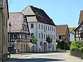
Manor house, left: Gasthaus Adler from 1605

House with cross gable from 1809

Bear fountain


The Buchenauerhof , which belongs to Weiler, with its castle-like main building is the seat of the German Mission Community, the agricultural land belonging to the Buchenauerhof is largely used by the Sinsheim Golf Club.
societies
- German Red Cross local association and readiness Weiler : The DRK Weiler is a local association in the district association Rhein-Neckar / Heidelberg eV The local association consists of a readiness and a youth department. The fields of activity consist of local hazard prevention and disaster control.
- FC Weiler 1946 eV : football club
- Weiler volunteer fire brigade : The Weiler volunteer fire brigade was founded in January 1939 and had 32 members. In October 1942 the first portable pump was then ordered from the Maschinenbau AG Blacke company in Frankenthal. In 1958 the fire brigade received a new TS 8/8 from the Ziegler company. The fire station extension was completed in 2004 .
- Motorsport- und Oldtimerclub eV Steinsberg : The club was founded on December 18, 1979 by 30 members. Among them were the brothers Joachim and Wolfgang Reich, who managed to become German cross-country champions in 1971 and 1977. Another prominent member is Franz Haaf, German Trial Champion 1982.
- Gymnastics and Sports Club TSV 1920 Weiler e. V .: has the departments of apparatus gymnastics male and female, gymnastics youth and adults, senior gymnastics, fistball, tennis, athletics, cycling.
Regular events
Every year there is an alternating summer festival at Burg Steinsberg and the Steinsberg Festival; The former offers theater, the latter various concerts of all kinds. During the Sinsheim Culture Days, which take place every autumn, there are usually events in Weiler. Every two years the local associations hold a village festival for a weekend .
Economy and Infrastructure
For a long time the village was predominantly agricultural. Worth mentioning is the sandstone quarry in Weiler, from whose stones u. a. the Mannheim water tower was built. For a long time, the most important employer in Weiler was the EGO company , which in 1977 offered almost 350 jobs.
traffic
There are district roads to Sinsheim, rows, Hilsbach and Waldangelloch. The Sinsheim city bus provides an hourly bus connection to Sinsheim or Hilsbach during the day during the day. Other bus connections lead in the direction of Eppingen / Elsenz. In the direction of Sinsheim, outside of the regular bus traffic, it is possible to take the dial-a- ride bus .
The Kraichgau-Stromberg Castle Tour , an approximately 52-kilometer regional cycle route that connects the town with the surrounding towns of Steinsfurt and Waldangelloch, runs through hamlets .
education
- Hilsbach-Weiler primary school
- Protestant kindergarten "Daisy"
- Municipal kindergarten "Rainbow" for Hilsbach and Weiler
- Branch of the Volkshochschule Sinsheim
Sons and daughters of the church
- Carl Wilhelm Friedrich Ludwig Stocker , Protestant pastor and local history researcher .
Individual evidence
- ↑ Communications from the Württ. And Bad. State Statistical Office No. 2: Results of the population census on December 31, 1945 in North Baden
- ^ Federal Statistical Office (ed.): Historical municipality directory for the Federal Republic of Germany. Name, border and key number changes in municipalities, counties and administrative districts from May 27, 1970 to December 31, 1982 . W. Kohlhammer, Stuttgart / Mainz 1983, ISBN 3-17-003263-1 , p. 479 .
- ^ Erwin Huxhold: The half-timbered houses in Kraichgau , Ubstadt-Weiher 2002, pp. 258–260.
- ↑ Kraichgau-Stromberg: Castle Tour | Vacation country Baden-Wuerttemberg. Retrieved June 21, 2020 .
literature
- Käthe Zimmermann-Ebert: Large district town Sinsheim - around the Steinsberg. Sinsheim 1990
Web links

Adersbach | Dühren | Ehrstädt | Eschelbach | Hasselbach | Hilsbach | Hoffenheim | Core city | Rows | Rohrbach | Steinsfurt | Forest fishing hole | hamlet