
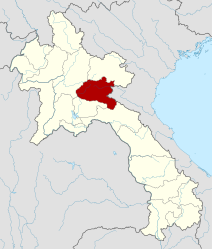
Xieng Khouang Province
| ຊຽງ ຂວາງ Xieng Khouang
|
|
|---|---|
  |
|
| Basic data | |
| Country | Laos |
| Capital | Phonsavan |
| surface | 15,880 km² |
| Residents | 244,684 (2015 census) |
| density | 15 inhabitants per km² |
| ISO 3166-2 | LA-XI |
 |
|
Coordinates: 19 ° 30 ′ N , 103 ° 30 ′ E

Xieng Khouang ( Laotian ຊຽງ ຂວາງ , Thaiเชียง ขวาง, ALA-LC : Sīang Khwāng , pronunciation: [síəŋ kʰwǎːŋ] , also Xiengkhouang , Xiengkhuang , Xiangkhoang , Xieng Khuang , Xieng Khwang , Chiang Khwang or Sieng Khwang in the north of Laos ) is a province . It was heavily bombed during the Lao Civil War , a sideline to the Vietnam War .
In the province there is the famous plains of the clay jugs . In addition, the three highest mountains of Laos with heights of up to 2850 meters ( Phu Bia ) are located in this province.
geography
Neighboring provinces are (clockwise from the south): Bolikhamsai , Saysomboun , Luang Prabang and Houaphan . To the east, Xieng Khouang borders the provinces of Thanh Hóa and Nghệ An of Vietnam . The capital of the province and largest city is Phonsavan , the second largest city is the former capital Muang Khoun .
traffic
Lao Airlines connects the local airport (IATA code XKH) near the provincial capital Phonsavan with the capital Vientiane four times a week.
The national road 7 offers an east-west connection through the province: It begins in the east on the border with Vietnam at the border station Nong Het and leads from there in a westerly direction to Luang Prabang . National road 6 begins at the intersection with national road 7 in Muang Kham and runs from there in a north-easterly direction to the Vietnamese border in the north-east of Houaphan province. In the meantime, the road from Phonsavan to the south 1D is paved throughout and bridges have been built so that river crossings are no longer necessary.
history

The original inhabitants and creators of the stone jars stored in the "Plain of the Clay Jars" and dating back to the Iron Age were probably ancestors or relatives of today's Khmu (or Lao Theung ) people. The Phuan Tai people later took control of the area. They formed the tribal principality of Müang Phuan or Xieng Khouang. According to legend, it was founded by Chet Cheuang, the youngest son of the mythical progenitor of the Tai peoples, Khun Borom .
Around 1350 it was conquered by Fa Ngum , the founder of the Kingdom of Lan Xang , and belonged to his mandala (sphere of influence) during the following centuries (with interruptions ). However, it retained its own princes who were indebted to the kings of Lan Xang as vassals. In 1480 a Vietnamese army devastated Xieng Khouang as punishment for his alliance with Lan Xang and in revenge for the unsuccessful attempt to make the principality a province of its own empire. During the following centuries there were repeated attempts to subordinate Xieng Khouang to Vietnamese rule. An uprising against Lan Xang is documented around 1651/52, when the then Prince of Xieng Khouang refused to give King Sulinyavongsa his daughter to wife. The latter's army then devastated the Phuan country and abducted around 500 families into its direct domain.
As a result of the division of Lan Xang into several principalities in 1707, Xieng Khouang initially received extensive autonomy again. In the 19th century, however, it was the subject of multiple battles between Siam , Vietnam and the Lao states for supremacy. Thousands of Phuan families were deported as workers by the victorious armies, including to what is now Thailand. After the failed rebellion of King Anuvong of Vientiane against Siamese supremacy in 1827/28, Vietnam tried again to gain control of what it considered to be the Vietnamese province of Tran Ninh . However, this met with opposition from both the local Phuan and Siams. In 1872 the area was overrun by Black Flag Ho rebels ( Ho Wars ). From 1883 to 1885 Siam led a campaign here and to Luang Prabang to secure its supremacy over the area. In 1893, however, it had to cede it as a result of the French-Siamese treaty. Xieng Khouang first became a French protectorate, then in 1899 it was fully incorporated into French Laos. In 1941, Xieng Khouang became part of the Kingdom of Luang Prabang (under French protectorate) to compensate for the territories it had lost as a result of the Franco-Thai War .
In the Lao Civil War , Xieng Khouang came under the control of the neutralist troops of General Kong Le in December 1960 in association with the procommunist Pathet Lao . From January 1961 to mid-1962, the small town of Khang Khai near Xieng Khouang was the seat of the neutralist counter-government of Prince Souvanna Phouma . After Kong Les's influence declined and his neutralist forces split, the province remained a bastion of the Pathet Lao. From 1964 to 1973 it was exposed to the most violent area bombing by the American Air Force, which devastated the region. Most of the 260 million bombs dropped on Laos during this period hit this province. Since almost a third of them did not explode immediately, duds are still a serious problem. After the end of the war and the founding of the People's Democratic Republic of Laos, there was a proposal to build the country's new capital in Phonsavan. This was not implemented, but Phonsavan got a larger airfield with Soviet and Vietnamese support.
population
The population consists mainly of Phuan , so-called Lao Soung (especially Hmong ) and Khmu . Lao are in the minority here. Also represented are Tai Daeng ("Red Tai"), Tai Meuy and Tai Nüa .
Culture
The Xieng Khouang style is the oldest among the Lao temple styles. It was characterized by a sweeping eaves and a single roof line. It was later developed into the Luang Prabang style.
Administrative division
The province consists (status: 2013) of the following eight districts ( ເມືອງ - [ mʉ̄aṅ ]):
| code | District | Lao |
|---|---|---|

|
||
| 09-01 | Pek | ເມືອງ ແປກ |
| 09-02 | Kham | ເມືອງ ຄຳ |
| 09-03 | Nonghed | ເມືອງ ໜອງ ແຮດ |
| 09-04 | Khoune | ເມືອງ ຄູນ |
| 09-05 | Morkmay | ເມືອງ ໝອກ ໃໝ່ |
| 09-06 | Phookood | ເມືອງ ພູ ກູດ |
| 09-07 | Phaxay | ເມືອງ ຜາ ໄຊ |
| 09-08 | Thatom | ເມືອງ ທ່າ ໂທມ |
Note: Thatom District was assigned to Xieng Khouang Province in January 2006 when the Saysomboun Special Zone was dissolved. In 2013 the former special zone was re-established as the province of Saysomboun .
Sons and Daughters of the Province
- Faydang Lobliayao (1910–1986), Hmong guerrilla and Pathet Lao leader, after 1975 Vice President of the Supreme People's Assembly and the Lao Front for National Construction
- Vang Pao (* 1931), General of the Royal Laotian Army and organizer of the "secret army" of the CIA in the Laotian civil war, consisting mainly of Hmong guerrillas
- Chanty Deuansavanh (* 1940), journalist and writer, SEA Write Award 1999
- Bounpheng Mounphoxay (* 1948), communist politician, governor of Xieng Khouang (first woman to head a province), member of the central committee of the LRVP
Individual evidence
- ↑ Archived copy ( memento of the original from October 18, 2009 in the Internet Archive ) Info: The archive link was inserted automatically and has not yet been checked. Please check the original and archive link according to the instructions and then remove this notice.
- ↑ Martin Stuart-Fox : Historical Dictionary of Laos. 3rd edition, Scarecrow Press, 2008, p. 165.
- ↑ Stuart-Fox: Historical Dictionary of Laos. 2008, p. 101.
- ↑ Stuart-Fox: Historical Dictionary of Laos. 2008, p. 373.
- ↑ Stuart-Fox: Historical Dictionary of Laos. 2008, p. 332.
- ↑ Stuart-Fox: Historical Dictionary of Laos. 2008, p. 266.
- ↑ Stuart-Fox: Historical Dictionary of Laos. 2008, p. 353.
- ^ A b Stuart-Fox: Historical Dictionary of Laos. 2008, p. 388.
- ^ Ian MacKinnon: Forty years on, Laos reaps bitter harvest of the secret war. In: The Guardian , December 3, 2008.
- ↑ Stuart-Fox: Historical Dictionary of Laos. 2008, p. 17.
Provinces: Attapeu | Bokeo | Bolikhamsai | Champasak | Houaphan | Khammuan | Luang Namtha | Luang Prabang | Oudomxay | Phongsali | Sainyabuli | Salavan | Savannakhet | Saysomboun | Sekong | Vientiane | Xieng Khouang
Prefecture: Vientiane