
Zwota (river)
|
Zwota Zwodau, Svatava |
||
 Estuary into the Eger in Sokolov |
||
| Data | ||
| Water code | DE : 53234, CZ : 1-13-01-094 | |
| location | Saxony (Germany), Czech Republic | |
| River system | Elbe | |
| Drain over | Eger → Elbe → North Sea | |
| source | as Zwotawasser (Kleine Zwota) near the Kärnerstraße near Schöneck 50 ° 22 ′ 15 ″ N , 12 ° 21 ′ 14 ″ E |
|
| Source height | 715 m above sea level NN | |
| muzzle | in Sokolov in the Eger coordinates: 50 ° 11 ′ 0 ″ N , 12 ° 38 ′ 26 ″ E 50 ° 11 ′ 0 ″ N , 12 ° 38 ′ 26 ″ E |
|
| Mouth height | 388.1 m nm | |
| Height difference | 326.9 m | |
| Bottom slope | 8th ‰ | |
| length | 41 km | |
| Catchment area | 295 km² | |
| Discharge at the Klingenthal 1 A Eo gauge : 58.62 km² Location: 12.1 km above the mouth |
NNQ (11/01/1984) MNQ 1961/2010 MQ 1961/2010 Mq 1961/2010 MHQ 1961/2010 HHQ (12/08/1974) |
90 l / s 247 l / s 1.19 m³ / s 20.3 l / (s km²) 11.2 m³ / s 40.8 m³ / s |
| Discharge at the Kraslice A Eo gauge: 115.12 km² Location: 24 km above the mouth |
MQ Mq |
1.52 m³ / s 13.2 l / (s km²) |
| Discharge at the Svatava A Eo gauge: 291.64 km² Location: 1.1 km above the mouth |
MQ Mq |
3.67 m³ / s 12.6 l / (s km²) |
The Zwota , in Bohemia Zwodau , also Zwotau (Czech Svatava ) is a left tributary of the Eger in Germany and the Czech Republic .
course
The river rises as Zwotawasser ( called Kleine Zwota by the residents of the area ) east of Kärnerstrasse on Gunzener Flur and joins between Zwotental and Oberzwota with the significantly larger Wolfsbach, the one between Schöneck / Vogtl. and Kottenheide rises. From here the stream is called Zwota up to the Czech border.
The valley of the Zwota then runs in an easterly direction between the Wolfsberg (771 m) in the north and the Hohen Brand . The towns of Oberzwota, Zechenbach, Zwota and Klingenthal , where the Brunndöbra flows into, extend along the river . Below the confluence, the body of water flowing to the southeast is known as Zwodau or Zwotau and forms the state border between Saxony and the Czech Republic for a kilometer and a half before it flows in a deeply cut valley through the Bohemian Ore Mountains . Along the Zwodau the city is Kraslice (German Graslitz ), thereafter the run goes through the Annatal to Anenské UDOLI ( Annathal ) and in several river bends over Hory ( Horn ), Oloví ( Bleistadt ) Hřebeny ( Hartberg ) and Luh ( Werth ) in the brown coal field of the Falkenau basin . Hartenberg Castle is located above Hřebeny . This is the only castle on the course of the Zwodau. On the lower reaches of the Zwodau are the places Davidov and Svatava ( Zwodau ). After 41 km the Svatava flows into the Eger in Sokolov ( Falkenau ) .
Surname
The water is mentioned for the first time as Zvatowa in the dedication certificate of the Plauen St. John's Church from 1122, in which it is part of the border of the associated church district, the Dobnagau , and thus at the same time the southern border of the diocese of Naumburg . The Zwota is also mentioned as Zuata in the border descriptions of the Schönbacher Ländchen from 1181 and 1185, here it forms the eastern border of the possessions of the Waldsassen monastery . The meaning of the word could be derived from the Czech Svatý = holy , alluding to the border function between the dioceses; the translation Grenzwasser from Sorbian Suwoda was also suggested.
Tributaries
- Siebenbuchenbächel (l), Oberzwota
- Zechenbach (l), Zwota
- Hüttenbach (r), Zwota
- Glasbach (l), Zwota
- Klausenbach (l), Klingenthal
- Dürrenbach (l), Klingenthal
- Brunndöbra (l), Klingenthal
- Quittenbach (Grenzbach) (l),
- Bublavský potok ( Schwaderbach ) (l), Kraslice (Graslitz)
- Stříbrný potok ( Silberbach ) (l), Kraslice (Graslitz)
- Rotava ( Rothau ) (l), Anenské Údoli (Annathal)
photos

Source of the Zwota water (Kleine Zwota) near the Kärnerstrasse near Gunzen

Wolfsbach spring below Schöneck

Course of the Zwota in Oberzwota

the Zwota on the border with the Czech Republic

in Kraslice

Ford through the Zwota to Kraslice

small hydroelectric power station between Kraslice and Oloví
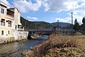
big bridge in Oloví

below Hartenberg Castle


particularities
The Zwotatal represented an important traffic route through the Ore Mountains. In addition to roads, there is also a railway connection from Zwickau via Zwotental, Klingenthal and Kraslice along the river to Sokolov .
See also
Individual evidence
- ↑ Sign at the source
- ↑ Základní characteristic toku svatava a jeho povodí (PDF; 1.8 MB)
- ↑ a b Michael Bergemann: Complete list of flowing waters in the Elbe catchment area. (PDF; 791 kB) Working group for keeping the Elbe clean, July 1, 2015, accessed on October 9, 2015 .
- ↑ Hydrological Handbook. (PDF; 637 kB) Part 3 - Main aquatic values. Free State of Saxony - State Office for Environment and Geology, p. 62 , accessed on December 25, 2017 .
- ↑ Český hydrometeorologický ústav
- ↑ Český hydrometeorologický ústav
- ^ Pietsch, Ernst: The document of Bishop Dietrich I von Naumburg on the consecration of St. John's Church in 1122. In: Festschrift for the 800th anniversary of the St. John's Church in Plauen. Published by the parish council of St. Johannis. Plauen 1922, p. 3f.
- ^ Bönhoff, Leo : The Plauen Parish and its development in the period from 1122 to 1905. In: Mitteilungen des Altertumsverein zu Plauen i. V. 19th annual journal. Plauen 1908
- ^ Muggenthaler, Hans : Colonizing and economic activity of a German Cistercian monastery in the XII. and XIII. Century (discussed by Josef Pfitzner). In: Communications from the Institute for Austrian Historical Research . Volume 42. Innsbruck 1927. P. 126 ff.
- ^ Greule, Albrecht: Deutsches Gewässernamenbuch. Berlin / Boston 2014. p. 619