
Jászszentlászló: Difference between revisions
Content deleted Content added
added railfan link to train station |
tag with {{Bare URL image}} |
||
| (44 intermediate revisions by 35 users not shown) | |||
| Line 1: | Line 1: | ||
{{Infobox settlement |
|||
{{verify}} |
|||
<!-- See Template:Infobox settlement for additional fields and descriptions --> |
|||
[[Image:jaszszentlaszlo_small.jpg|thumb]] |
|||
|image_skyline = jaszszentlaszlo small.jpg |
|||
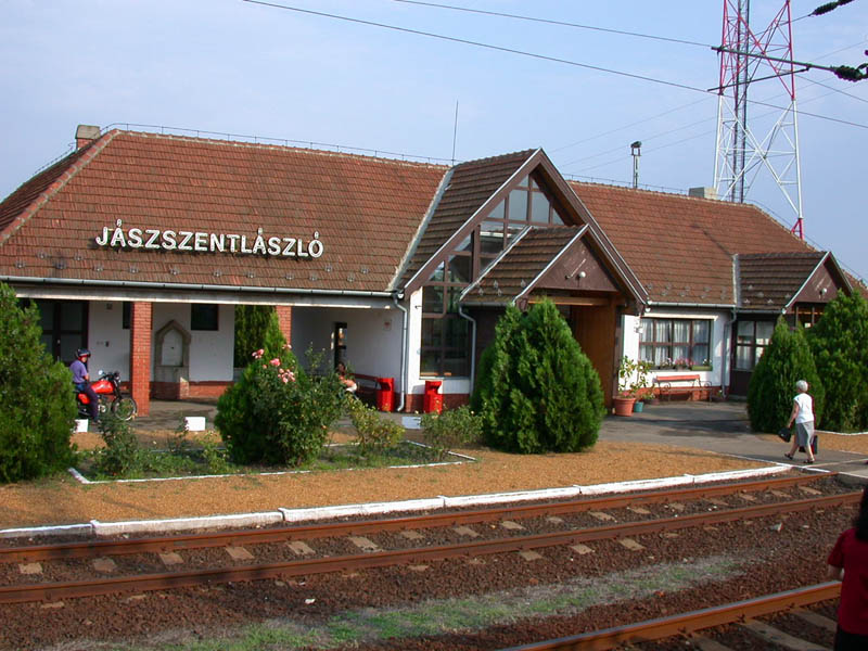
'''Jaszszentlaszlo''' is a small village in Hungary, of [[Bacs-Kiskun]] county, just south of [[Kiskunfelegyhaza]] and just north of [[Kiskunmajsa]]. It is on the railroad line between [[Kecskemet]] and [[Szeged]] ([http://www.railfaneurope.net/pix/hu/station/misc_G-J/jaszszentlaszlo.jpg railroad enthusiast's photo of the train station].) |
|||
|settlement_type = <!--For Town or Village (Leave blank for the default City)--> |
|||
|subdivision_type = [[Countries of the world|Country]] |
|||
|subdivision_name = {{HUN}} |
|||
|coordinates = |
|||
<!--If coordinates are filled in above remove ed notes from "Hungary" in pushpin_map field to display map--> |
|||
This page that catalogs [http://lazarus.elte.hu/citymap/bac/jsztl.htm maps ] gives a 1995 population of 2722, which seems consistent with other estimates gleaned from the web of 2500. |
|||
|pushpin_map = <!--Hungary--> |
|||
|pushpin_label_position = <!-- the position of the pushpin label: left, right, top, bottom, none --> |
|||
|pushpin_map_caption = |
|||
|pushpin_mapsize = |
|||
|timezone=[[Central European Time|CET]] |
|||
|utc_offset=+1 |
|||
|timezone_DST=[[Central European Summer Time|CEST]] |
|||
|utc_offset_DST=+2 |
|||
| |
|||
official_name=Jászszentlászló| |
|||
picture=| |
|||
subdivision_type1=[[Counties of Hungary|County]]| |
|||
subdivision_name1=Bács-Kiskun| |
|||
area_total_km2=60.34| |
|||
population_as_of=2002| |
|||
population_total=2632| |
|||
population_density_km2=44| |
|||
postal_code_type=[[Postal code]]| |
|||
postal_code=6133| |
|||
area_code=77| |
|||
}} |
|||
[[Image:BacsKiskunCounty.png|thumb|right|300px|Location of [[Bács-Kiskun]] |
|||
| ⚫ | |||
county in [[Hungary]]]] |
|||
'''Jászszentlászló''' is a [[village]] in [[Bács-Kiskun]] county, in the [[Southern Great Plain]] [[region]] of southern [[Hungary]]. It lies just south of [[Kiskunfélegyháza]] and just north of [[Kiskunmajsa]]. The town is a stop<ref>http://www.railfaneurope.net/pix/hu/station/misc_G-J/jaszszentlaszlo.jpg {{Bare URL image|date=March 2022}}</ref> on the railroad line between [[Kecskemét]] and [[Baja, Hungary|Baja]]. |
|||
==Geography== |
|||
| ⚫ | |||
It covers an [[area]] of {{convert|60.34|km2|sqmi|0|abbr=on}} and has a [[population]] of 2632 people (2002). |
|||
{{uncat}} |
|||
{{unref}} |
|||
==Economy== |
|||
| ⚫ | |||
== References == |
|||
{{reflist}} |
|||
== External links == |
|||
*{{in lang|hu}} [http://www.jaszszentlaszlo.hu/ Hivatalos oldal] |
|||
*{{in lang|hu}} [http://www.jaszszentlaszlo.lap.hu Startlap linkgyűjtemény] |
|||
{{coord|46|34|N|19|46|E|region:HU_type:city|display=title}} |
|||
{{Bács-Kiskun}} |
|||
{{authority control}} |
|||
{{DEFAULTSORT:Jaszszentlaszlo}} |
|||
[[Category:Populated places in Bács-Kiskun County]] |
|||
| ⚫ | |||
Latest revision as of 05:38, 25 March 2022
Jászszentlászló | |
|---|---|
 | |
| Country | |
| County | Bács-Kiskun |
| Area | |
| • Total | 60.34 km2 (23.30 sq mi) |
| Population (2002) | |
| • Total | 2,632 |
| • Density | 44/km2 (110/sq mi) |
| Time zone | UTC+1 (CET) |
| • Summer (DST) | UTC+2 (CEST) |
| Postal code | 6133 |
| Area code | 77 |

Jászszentlászló is a village in Bács-Kiskun county, in the Southern Great Plain region of southern Hungary. It lies just south of Kiskunfélegyháza and just north of Kiskunmajsa. The town is a stop[1] on the railroad line between Kecskemét and Baja.
Geography[edit]
It covers an area of 60.34 km2 (23 sq mi) and has a population of 2632 people (2002).
Economy[edit]
There are several agricultural enterprises. Some pumpjacks still raise crude oil from the ground.
References[edit]
External links[edit]
- (in Hungarian) Hivatalos oldal
- (in Hungarian) Startlap linkgyűjtemény
46°34′N 19°46′E / 46.567°N 19.767°E


This Bács-Kiskun location article is a stub. You can help Wikipedia by expanding it. |