České Heřmanice: Difference between revisions
Content deleted Content added
m r2.7.1) (Robot: Adding it:České Heřmanice |
m r2.7.3) (Robot: Adding ms:České Heřmanice |
||
| Line 20: | Line 20: | ||
[[fr:České Heřmanice]] |
[[fr:České Heřmanice]] |
||
[[it:České Heřmanice]] |
[[it:České Heřmanice]] |
||
[[ms:České Heřmanice]] |
|||
[[nl:České Heřmanice]] |
[[nl:České Heřmanice]] |
||
[[sk:České Heřmanice]] |
[[sk:České Heřmanice]] |
||
Revision as of 07:25, 12 February 2013

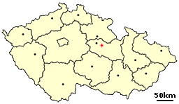
České Heřmanice is a village in the Pardubice Region of the Czech Republic. It has around 530 inhabitants.
Villages Borová, Chotěšiny and Netřeby are administrative parts of České Heřmanice.
External links
- Village website (in Czech)
