
Valea Lungă, Alba
Valea Lungă | |
|---|---|
 | |
 Location in Alba County | |
| Country | |
| County | Alba County |
| Population (2011)[1] | |
| • Total | 2,907 |
| Time zone | UTC+2 (EET) |
| • Summer (DST) | UTC+3 (EEST) |
Valea Lungă (formerly Hususău; German: Langenthal, Hungarian: Hosszúaszó) is a commune located in Alba County, Romania. Is composed of six villages: Făget (Oláhbükkös), Glogoveț (Kisgalgóc), Lodroman (Lodormány), Lunca (Küküllőlonka), Tăuni (Hosszúpatak) and Valea Lungă.
Placing
Valea Lungă City is located in the meadow Târnavei Mare, about 11 km from Blaj, in the direction of Copsa Mica
History
Documentary of the existence of the village we have from the beginning of the fourteenth century. In 1309 reminded of the existence of an archdeacon of which was locality Long Valley, mentioning Arnold Longavalle priest of this town.
In XIV century the town is also mentioned several times in historical documents. In 1322 Karol Robert, king of Hungary, donated the village of Long Valley with village Micăsasa Count Nicolaus in Tălmaciu and villages Panada and Sona Valley Small Târnavei. These places belonged to Prince Ladislaus this year which have been taken to infidelity and data Nicolaus. Nicolaus died in 1340 without leaving descendants.
Tomas estate gives its ruler King except of Valea Lunga - this time called "Huziuazo" and Micăsasa village yet the king keeps in its field. Long Valley City in 1359 is maintained in regal. In 1395 the town was in possession of several noble however. It recalls this year of a boundary between the villages and Balcaciu Jidvei and the town of Long Valley nobles here.
Sights
- The whole evangelical church, XIVth century building
Note
- ^ x indică operatorul telefonic: 2 pentru Romtelecom și 3 pentru alți operatori de telefonie fixă
External links
- Pagina de Facebook a Comunei Valea Lunga
- Pagina Primăriei din Valea Lungă
- Template:De iconLangentahl („Valea Lungă”) la „Siebenbürger.de Orte“
- Template:De iconWebsitul Langenthalerilor
- Template:Hu iconEvoluția demografică a populației din județul Alba între anii 1850-2002 (autor: Varga E. Arpád)
- Poze si scurta descriere
- Dicționar de localități din Transilvania
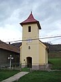
Gallery
-
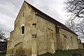
Lutheran church -

Reformed church (ca. 1780) -

Roman Catholic church -
Greek-Catholic church (1893) -

Romanian Orthodox church -

Village road -

Heroes' monument
.JPG)
.JPG)
.JPG)
.JPG)
.JPG)
.JPG)
.JPG)
References
- ^ Template:Ro icon Populația stabilă după etnie - județe, municipii, orașe, comune, National Institute of Statistics; accessed December 30, 2015

46°07′30″N 24°02′35″E / 46.12500°N 24.04306°E
This Alba County location article is a stub. You can help Wikipedia by expanding it. |