České Heřmanice: Difference between revisions
Content deleted Content added
→External links: remove category using AWB |
Cote d'Azur (talk | contribs) |
||
| Line 7: | Line 7: | ||
==External links== |
==External links== |
||
| ⚫ | |||
* [http://www.ceskehermanice.cz/ Village website] (in Czech) |
* [http://www.ceskehermanice.cz/ Village website] (in Czech) |
||
{{Ústí nad Orlicí District}} |
{{Ústí nad Orlicí District}} |
||
{{coord|49|56|N|16|15|E|region:CZ_type:city(533)|display=title}} |
{{coord|49|56|N|16|15|E|region:CZ_type:city(533)|display=title}} |
||
| ⚫ | |||
{{DEFAULTSORT:Ceske Hermanice}} |
{{DEFAULTSORT:Ceske Hermanice}} |
||
Revision as of 17:29, 2 November 2017


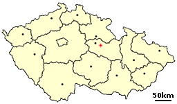
České Heřmanice (Ger. Hermanitz) is a village in the Pardubice Region of the Czech Republic. It has around 530 inhabitants.
Villages Borová, Chotěšiny and Netřeby are administrative parts of České Heřmanice.
External links
Wikimedia Commons has media related to České Heřmanice.
- Village website (in Czech)
49°56′N 16°15′E / 49.933°N 16.250°E
