Felsőszentiván: Difference between revisions
Content deleted Content added
m robot Adding: sk:Felsőszentiván |
Replacing BacsKiskunCounty.gif with File:BacsKiskunCounty.png (by CommonsDelinker because: file renamed on Commons). |
||
| (21 intermediate revisions by 16 users not shown) | |||
| Line 1: | Line 1: | ||
{{Use dmy dates|date=November 2018}} |
|||
{{Infobox |
{{Infobox settlement <!--more fields are available for this Infobox--See Template:Infobox settlement--> |
||
|subdivision_type = [[Countries of the world|Country]] |
|subdivision_type = [[Countries of the world|Country]] |
||
|subdivision_name = {{HUN}} |
|subdivision_name = {{HUN}} |
||
| Line 12: | Line 13: | ||
official_name=Felsőszentiván| |
official_name=Felsőszentiván| |
||
map=<!--<div style="position: relative">[[ |
map=<!--<div style="position: relative">[[File:HU county Bacs-Kiskun.svg|275px]]<div style="position: absolute; left: 110px; top: 146px">[[File:Red_Dot.gif]]</div></div>-->| |
||
subdivision_type1=[[Counties of Hungary|County]]| |
subdivision_type1=[[Counties of Hungary|County]]| |
||
subdivision_name1=[[Bács-Kiskun]]| |
subdivision_name1=[[Bács-Kiskun]]| |
||
area_total_km2=53.54| |
area_total_km2=53.54| |
||
population_total=1815<ref name="HunStat2015">''[http://www.ksh.hu/apps/shop.kiadvany?p_kiadvany_id=81322&p_temakor_kod=KSH&p_session_id=800051036609396&p_lang=EN Gazetteer of Hungary, 1 January 2015]''. Hungarian Central Statistical Office. 3 September 2015</ref>|population_footnotes=| |
|||
population_total=2048|population_footnotes=| |
|||
population_as_of= |
population_as_of=2015|population_density_km2=38.25| |
||
|postal_code_type=[[Postal code]]| |
|postal_code_type=[[Postal code]]| |
||
postal_code=6447| |
postal_code=6447| |
||
area_code=79 |
area_code=79 |
||
|coordinates = {{coord|46.1950|19.1903|region:HU|display=inline,title}} |
|||
latd=46.1950| |
|||
| |
|||
longd=19.1903| |
|||
}} |
}} |
||
[[ |
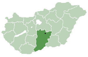
[[File:BacsKiskunCounty.png|thumb|right|300px|Location of [[Bács-Kiskun]] |
||
county in [[Hungary]]]] |
county in [[Hungary]]]] |
||
'''Felsőszentiván''' (Croatian: ''Gornji Sveti Ivan'' and ''Gornji Sentivan'') is a [[village]] and [[municipality]] in [[Bács-Kiskun]] county, in the [[Southern Great Plain]] [[region]] of southern [[Hungary]]. |
'''Felsőszentiván''' (Croatian: ''Gornji Sveti Ivan'' and ''Gornji Sentivan'') is a [[village]] and [[municipality]] in [[Bács-Kiskun]] county, in the [[Southern Great Plain]] [[region]] of southern [[Hungary]]. |
||
==Geography== |
==Geography== |
||
It covers an [[area]] of {{ |
It covers an [[area]] of {{Convert|53.54|km2|sqmi|0|abbr=on}} and has a [[population]] of 2015 people (2015).<ref name="HunStat2015"/> |
||
==Demographics== |
==Demographics== |
||
Existing ethnicities: |
Existing ethnicities: |
||
* {{ |
* {{Flagicon|Hungary}} [[Magyars]] |
||
* {{ |
* {{Flagicon|Croatia}} [[Croats]] |
||
== |
==Notable persons== |
||
* [[Petar Pekić]], Croatian writer and historian |
* [[Petar Pekić]], Croatian writer and historian |
||
* [[Anka Jelačić]], Croatian opera singer ([[mezzo-soprano]]) |
|||
==References== |
|||
* [[Ivan Petreš Čudomil]], Croatian writer, worked as priest in Felsőszentiván |
|||
{{reflist}} |
|||
{{Bács-Kiskun}} |
{{Bács-Kiskun}} |
||
| ⚫ | |||
{{authority control}} |
|||
{{DEFAULTSORT:Felsoszentivan}} |
{{DEFAULTSORT:Felsoszentivan}} |
||
[[Category: |
[[Category:Populated places in Bács-Kiskun County]] |
||
[[eo:Felsőszentiván]] |
|||
| ⚫ | |||
[[hr:Gornji Sveti Ivan]] |
|||
[[hu:Felsőszentiván]] |
|||
[[pl:Felsőszentiván]] |
|||
[[sk:Felsőszentiván]] |
|||
[[sv:Felsőszentiván]] |
|||
Latest revision as of 14:03, 19 July 2020
Felsőszentiván | |
|---|---|
| Coordinates: 46°11′42″N 19°11′25″E / 46.1950°N 19.1903°E | |
| Country | |
| County | Bács-Kiskun |
| Area | |
| • Total | 53.54 km2 (20.67 sq mi) |
| Population (2015) | |
| • Total | 1,815[1] |
| • Density | 38.25/km2 (99.1/sq mi) |
| Time zone | UTC+1 (CET) |
| • Summer (DST) | UTC+2 (CEST) |
| Postal code | 6447 |
| Area code | 79 |

Felsőszentiván (Croatian: Gornji Sveti Ivan and Gornji Sentivan) is a village and municipality in Bács-Kiskun county, in the Southern Great Plain region of southern Hungary.
Geography[edit]
It covers an area of 53.54 km2 (21 sq mi) and has a population of 2015 people (2015).[1]
Demographics[edit]
Existing ethnicities:
Notable persons[edit]
- Petar Pekić, Croatian writer and historian
References[edit]
- ^ a b Gazetteer of Hungary, 1 January 2015. Hungarian Central Statistical Office. 3 September 2015


