Felsőszentiván: Difference between revisions
Content deleted Content added
m Robot - Moving category Cities, towns and villages in Bács-Kiskun county to Populated places in Bács-Kiskun county per CFD at Wikipedia:Categories for discussion/Log/2010 May 28. |
m Bot) Add coordinates_region and/or _display parameters (report errors? |
||
| Line 1: | Line 1: | ||
{{Unreferenced|date=November 2006}} |
{{Unreferenced|date=November 2006}} |
||
{{Infobox settlement <!--more fields are available for this Infobox--See Template:Infobox settlement--> |
{{Infobox settlement <!--more fields are available for this Infobox--See Template:Infobox settlement--> |
||
|coordinates_display = inline,title |
|||
|coordinates_region = HU |
|||
|subdivision_type = [[Countries of the world|Country]] |
|subdivision_type = [[Countries of the world|Country]] |
||
|subdivision_name = {{HUN}} |
|subdivision_name = {{HUN}} |
||
Revision as of 20:35, 17 June 2010
Felsőszentiván | |
|---|---|
| Country | |
| County | Bács-Kiskun |
| Area | |
| • Total | 53.54 km2 (20.67 sq mi) |
| Population (2005) | |
| • Total | 2,048 |
| • Density | 38.25/km2 (99.1/sq mi) |
| Time zone | UTC+1 (CET) |
| • Summer (DST) | UTC+2 (CEST) |
| Postal code | 6447 |
| Area code | 79 |

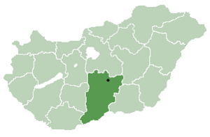
Felsőszentiván (Croatian: Gornji Sveti Ivan and Gornji Sentivan) is a village and municipality in Bács-Kiskun county, in the Southern Great Plain region of southern Hungary.
Geography
It covers an area of 53.54 km2 (21 sq mi) and has a population of 2048 people (2005).
Demographics
Existing ethnicities:
Notable persons
- Petar Pekić, Croatian writer and historian
- Anka Jelačić, Croatian opera singer (mezzo-soprano)
- Ivan Petreš Čudomil, Croatian writer, worked as priest in Felsőszentiván


