Hrušová: Difference between revisions
Content deleted Content added
Replacing geodata: {{coord|49|54|35|N|16|11|46|E|region:CZ|display=title}} |
Biruitorul (talk | contribs) + |
||
| Line 1: | Line 1: | ||
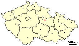
[[Image:Location of Czech city Vysoke Myto.png|right|frame|Location of Hrušová in the Czech Republic]] |
[[Image:Location of Czech city Vysoke Myto.png|right|frame|Location of Hrušová in the Czech Republic]] |
||
{{for|the commune in [[Criuleni district]], [[Moldova]]|Hruşova}} |
|||
'''Hrušová''' is a village in the [[Pardubice Region]] of the [[Czech Republic]]. It has around 350 inhabitants. |
'''Hrušová''' is a village in the [[Pardubice Region]] of the [[Czech Republic]]. It has around 350 inhabitants. |
||
Revision as of 04:30, 27 November 2009

Hrušová is a village in the Pardubice Region of the Czech Republic. It has around 350 inhabitants.
External links
- Village website (in Czech)
49°54′35″N 16°11′46″E / 49.90972°N 16.19611°E
