Old Grimme
| Old Grimme | ||
|---|---|---|
|
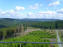
View of the Alte Grimme from the southwest |
||
| height | 755.1 m above sea level NHN | |
| location | near Elkeringhausen ; Hochsauerlandkreis , North Rhine-Westphalia , ( Germany ) |
|
| Mountains | Rothaar Mountains | |
| Dominance | 0.9 km → West flank Rösberg (Westgipfel Reetsberg ) | |
| Notch height | 73.6 m ↓ saddle to Rösberg | |
| Coordinates | 51 ° 11 '59 " N , 8 ° 35' 6" E | |
|
|
||

.
The Alte Grimme near Elkeringhausen in the North Rhine-Westphalian Hochsauerlandkreis is 755.1 m above sea level. NHN high mountain of the Rothaargebirge .
geography
location
The Alte Grimme is located in the northeast part of the Rothaar Mountains in the Sauerland-Rothaar Mountains Nature Park . Its summit rises about 900 m (as the crow flies ) southeast of the village church of the Winterberg district of Elkeringhausen, through which the Orke tributary flows.
Neighboring mountains or elevations are Rösberg ( 785.7 m ; northeast), Reetsberg ( 792.2 m ; east-northeast), Giebel ( 675.2 m ; east), Roth ( 624.6 m ; south-southeast), Steimel ( 573.4 m ; south) and castle ( 617 m ; southwest), and one of the mountains on the other side of Elkeringhausen is the Ruhrkopf ( 695.7 m ; northwest); here Roth and Steimel are offshoots of the Old Grimme .
The Orke tributary Deutmecke rises south-east of the Alte Grimme near its foothills Roth . Other short streams, which are direct tributaries of the Orcs or at least belong to their catchment area , arise around the mountain.
Natural allocation
The Alte Grimme belongs in the natural spatial main unit group Süderbergland (No. 33) in the main unit Rothaargebirge (with Hochsauerland ) (333) to the subunit Hohe Seite (333.7). The landscape leads to the north-west into the natural area Harfeld (333.56).
Mountain height and summit
The height of the 754.9 m high Alte Grimme is often only given as around 750 or 751 m , but this refers to a trigonometric point that is about 60 m northeast of the mountain summit at 750.7 m ; Topographic maps on the summit region provide additional height information: 753.5 m in the northeast and 753 m in the southwest.
There is a Bonifatius cross on the mountain top and a few meters away is the Grimme-Kreuz-Hütte as a refuge . On the summit region of the otherwise wooded mountain there is a narrow wild meadow .
Protected areas and nature
On the Alte Grimme there is a part of the Elkeringhauser forest consisting mainly of spruce trees . Parts of the nature reserve (NSG) Glindfeld Forest Reserve (LP Winterberg) ( CDDA no. 389938; designated 2008; 2.1 km² in size) lie on its north and north-east flank, while parts of the NSG Forest Reserve Glindfeld (LP Medebach) (CDDA ) lie on the eastern flank No. 319281; 2002; 21.53 km²). The NSG Butterfeld (CDDA no. 389693; 2008; 5 ha) is located on the transition area to the southern foothills of Roth , and the NSG Alte Grimme (CDDA no Hornbeam forest. No forestry was possible in this protected area and on the south-eastern flank of the mountain , which is why the natural forest was preserved; today such use is prohibited by law there. To the west of the NSG Alte Grimme is the NSG Ronsfeld (CDDA no. 389879; 2008; 9 ha). North-west of the mountain, directly above Elkeringhausen, is the south-west part of the NSG grassland complex upper Orke (CDDA No. 389754; 2008; 45 ha).
To the east, south and west of the Alte Grimme are parts of the Fauna-Flora-Habitat- Area Waldreservat Glindfeld-Orketal (with side valleys) (FFH-Nr. 4817-304; 29.97 km²) and to the north of the mountain those of the FFH-Area Oberes Orketal (FFH no. 4717-306; 2.69 km²). Parts of the European bird sanctuary in Medebacher Bucht (VSG no. 4717-401; 138.72 km²) extend to the eastern elevations of the mountain .
Colliery misery
About 50 m south of the southern edge of the NSG Butterfeld, located between the Alte Grimme and the Roth , is the tunnel mouth hole ( ⊙ ) of the former Elend colliery . Ore was mined there until 1914 . This happened without any significant success, which is why the approximately 30 m long tunnel was named Zeche Elend . The tunnel mouth hole is a protected landscape component (LB).
Traffic and walking
The Alte Grimme can only be reached on forest and hiking trails, for example starting at Kreisstraße 50, which runs from the Winterberg core town through Elkeringhausen to state road 740 leading in the direction of Küstelberg .
North, east and south past the mountain and also about its eastern highlands of the section will Elkeringhausen- Züschen (Stage 7) of the Winter Hochtour , an interconnecting trail the Winterberg districts, mountains and valleys of the well to mine misery leading historical trail of Elkeringhausen crosses.
Individual evidence
- ↑ a b c Topographical Information Management, Cologne District Government, Department GEObasis NRW ( information )
- ↑ Martin Bürgener: Geographical Land Survey: The natural spatial units on sheet 111 Arolsen. Federal Institute for Regional Studies, Bad Godesberg 1963. → Online map (PDF; 4.1 MB)
- ↑ Map services of the Federal Agency for Nature Conservation ( information )
- ↑ a b c Hochsauerlandkreis - landscape plan Winterberg (2008), in: Untere Landschaftsbehörde , p. 149, on gis.hochsauerlandkreis.de (PDF; 1.3 MB)
- ↑ a b Winterberger Hochtour ( Memento of the original from June 6, 2013 in the Internet Archive ) Info: The archive link was inserted automatically and has not yet been checked. Please check the original and archive link according to the instructions and then remove this notice. , with information about the route and u. a. to Zeche Elend (see stage 7 ), on winterberg.de

