Bäuerle (Ottobeuren)
|
Bäuerle
Ottobeuren market
Coordinates: 47 ° 56 ′ 14 ″ N , 10 ° 22 ′ 0 ″ E
|
|
|---|---|
| Height : | 755 m above sea level NN |
| Residents : | 6 (May 25 1987) |
| Postal code : | 87724 |
| Area code : | 08332 |
|
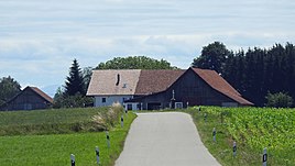
Farmer from the north
|
|
Bäuerle is a district of the Upper Swabian market Ottobeuren .
geography
The desert of Bäuerle is about six kilometers east of Ottobeuren. The homestead is connected to the main town by a country road via Eheim . The Schwarzbach , a right tributary of the Schwelk , flows through the Bäuerle area.
history
Bäuerle was built in the early 19th century. Opposite the present single farmstead there is a hall cross . As part of the regional reform in Bavaria , the place came to the Ottobeuren market on January 1, 1972 through the incorporation of the municipality of Betzisried.
literature
- Hermann Haisch (Ed.): Landkreis Unterallgäu . tape 2 .. Unterallgäu district, Mindelheim 1987, ISBN 3-9800649-2-1 , p. 1187 .
Web links
Individual evidence
- ↑ Bavarian State Office for Statistics and Data Processing (Ed.): Official local directory for Bavaria, territorial status: May 25, 1987 . Issue 450 of the articles on Bavaria's statistics. Munich November 1991, DNB 94240937X , p. 429 ( digitized version ).
- ^ Wilhelm Volkert (ed.): Handbook of Bavarian offices, communities and courts 1799–1980 . CH Beck, Munich 1983, ISBN 3-406-09669-7 , p. 521 .

