Świeradów-Zdrój
| Świeradów-Zdrój | ||
|---|---|---|

|
|
|
| Basic data | ||
| State : | Poland | |
| Voivodeship : | Lower Silesia | |
| Powiat : | Luban | |
| Area : | 20.77 km² | |
| Geographic location : | 50 ° 55 ′ N , 15 ° 21 ′ E | |
| Height : | 450-710 m npm | |
| Residents : | 4147 (June 30, 2019) |
|
| Postal code : | 59-850 | |
| Telephone code : | (+48) 75 | |
| License plate : | DLB | |
| Economy and Transport | ||
| Next international airport : | Wroclaw | |
| Gmina | ||
| Gminatype: | Borough | |
| Residents: | 4147 (June 30, 2019) |
|
| Community number ( GUS ): | 0210021 | |
| Administration (as of 2012) | ||
| Mayor : | Roland Marciniak | |
| Address: | ul. Piłsudskiego 15 59-850 Świeradów-Zdrój |
|
| Website : | www.swieradowzdroj.pl | |
Świeradów-Zdrój [ ɕfʲɛˈraduf ˈzdruɪ̯ ] (German Bad Flinsberg ) is a town and a health resort with 4240 inhabitants (as of December 2016) in south-western Poland in the Lower Silesian Voivodeship . It is a member of the Neisse Euroregion .
geography
Świeradów-Zdrój is located in the extreme southwest of Poland in the powiat Lubański in the Lower Silesian Voivodeship. The urban area borders directly on the Czech border in the west . The place is in the middle of the Jizera Mountains on the Queis River .
Wroclaw as the voivodeship capital is 150 km east of Świeradów-Zdrój. The district town of Lubań is about 30 km north of the spa. The two national roads Droga wojewódzka 358 and Droga wojewódzka 361 run through the health resort .
On the southern territory of today's city, directly on the border north-east of Klein Iser - formed by the Iser - lies the now deserted former farming village of Groß Iser , which was devastated shortly after the end of the Second World War .
history
The village on the eastern slopes of the 1,107 meter high Heufuders (Stóg Izerski), the neighboring summit of Tafelfichte , was first mentioned in the 1337th In the 17th century, the population increased significantly in Bohemia, triggered by the Counter Reformation, with the immigration of exiles . On July 15, 1682, the exiles and village judge of Rochlitz ad Iser , George Gernert the Younger , brought two hundred exiles and 300 cattle to the village lord of Uechtritz . The Silesian reformer Kaspar von Schwenckfeld and the chronicler Friedrich Lucae drew attention to a healing spring in the 17th century. The doctor Leonhard Thurneysser recognized the healing properties of spring water as early as 1572 .
After the publication of a memorandum by the Wigandsthal doctor Dr. Weist in the year 1738 began the spa operation in the Silesian place at the old triangle with Saxony , Silesia and Bohemia . In 1763 Flinsberg became a spa and bathing resort.
The fountain house at the upper fountain was built in 1768 and the first bath house in 1795. In 1811 a second healing spring was discovered, which from 1824 was also used for bathing.
In addition to the acidic springs (carbonated springs), seven steel springs (iron-containing springs) were used, two of which, the Heinrich-Quelle and the Julius-Quelle, were highly radium- containing and thus radioactive . The waters were used therapeutically for drinking cures and brine baths. In the following years, more bath houses were built, such as the Leopoldsbad (1838), the Ludwigsbad (1879) and the Marienbad (1904).
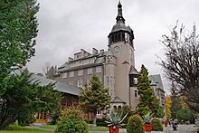
In 1895 large parts of the spa and bathing facilities burned down. A new prestigious spa house was inaugurated in 1899, and a radium bath was built in 1934. With around 3,000 inhabitants, 25,000 spa and recreational guests were counted in 1938.
In 1909, the Isergebirgsbahn AG established a railway connection between Friedeberg and Flinsberg .
Will-Erich Peuckert , who worked as a primary school teacher in Groß Iser between 1914 and 1921 , dealt intensively with the legends of the place.
In 1945 Bad Flinsberg, which had belonged to the Silesian district of Löwenberg , became part of Poland. It was named Świeradów-Zdrój and in the same year the city charter .
The Stóg cable car leads to the Heufuderbaude at 1060 m npm.
Population development
1786: 1,294 inhabitants
1825: 1,542
1905: 1,910
1939: 2,803
1961: 3,085
1970: 2,982
2004: 4,577
2005: 4,556
2008: 4,308
Twin cities
- Odder , Denmark, 1991
- Seifhennersdorf , Germany, 2002
- Jindřichovice pod Smrkem , Czech Republic
- Jilemnice , Czech Republic
- Mirsk , Poland
- Nové Město pod Smrkem , Czech Republic
- Lázně Libverda , Czech Republic
sons and daughters of the town
- Johann Gottlieb Wolstein (1738–1820), physician, pioneer of scientific veterinary medicine in German-speaking countries
- Otto Damerau (1877–1961), museum founder and honorary citizen of Hoyerswerda
- Klaus König (* 1934), law and administration scientist, university lecturer
- Rudolf Bahro (1935–1997), philosopher
- Herbert Gottwald (1937–2009), historian
local community

The municipality ( gmina miejska ) Świeradów-Zdrój covers an area of 20 km² with 5,157 inhabitants. Świeradów-Zdrój is the second richest municipality in Poland (2019). These include the town of Świeradów-Zdrój and the village of Czerniawa-Zdrój ( Bad Schwarzbach ). To the south the community extends to the Czech border, there is also the lonely mountain chalet Chatka Górzystów , the former school of the village Groß Iser , which was the only building in this abandoned village to be preserved.
Web links
- City website (German, Polish, English)
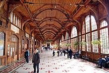
- Kurhaus, Kuranlage and Wandelhalle [1]
See also
Individual evidence
- ↑ a b population. Size and Structure by Territorial Division. As of June 30, 2019. Główny Urząd Statystyczny (GUS) (PDF files; 0.99 MiB), accessed December 24, 2019 .
- ↑ Karina Blüthgen: Expulsion: Lawless and Powerless in Years of Fear . Mitteldeutsche Zeitung , February 10, 2004, accessed on February 17, 2020
- ↑ E. Krause: The healing springs of the Jizera Mountains Bote from the Queistale March 1961, pp. 1–2
- ↑ Say. Birth and Answer of the Mythical World. Introductory volume to the European legends series . E. Schmidt, Berlin 1965 (p. 26 ff.)


